Danger Zones: Mt. Whitney
The Where—And Why—Of Accidents On California's Highest Mountain
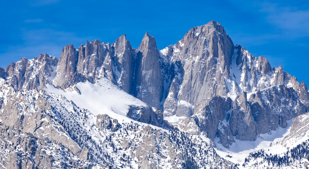
Mt. Whitney is unique in many respects: At 14,505 feet, it’s the highest mountain in the Lower 48; its home range, the Sierra Nevada, is wedged between extremes—the Pacific Ocean to the west and Death Valley to the east; it’s within easy driving distance of California’s largest population centers; and it’s a highly sought-after goal for peakbaggers and climbers alike.
Whitney is also known for being a hike, which it usually is. This perception drives a lot of traffic to its trails and slopes, but it’s also a big mountain. With nearly 7,000 feet of elevation gain from trailhead to summit, Whitney frequently straddles the line between hiking and mountaineering. Over 100,000 individuals compete for permits every year (see infographic p.52). Most of them are fair-weather hikers. When the perception of a hike collides with reality, people sometimes get injured, or killed.
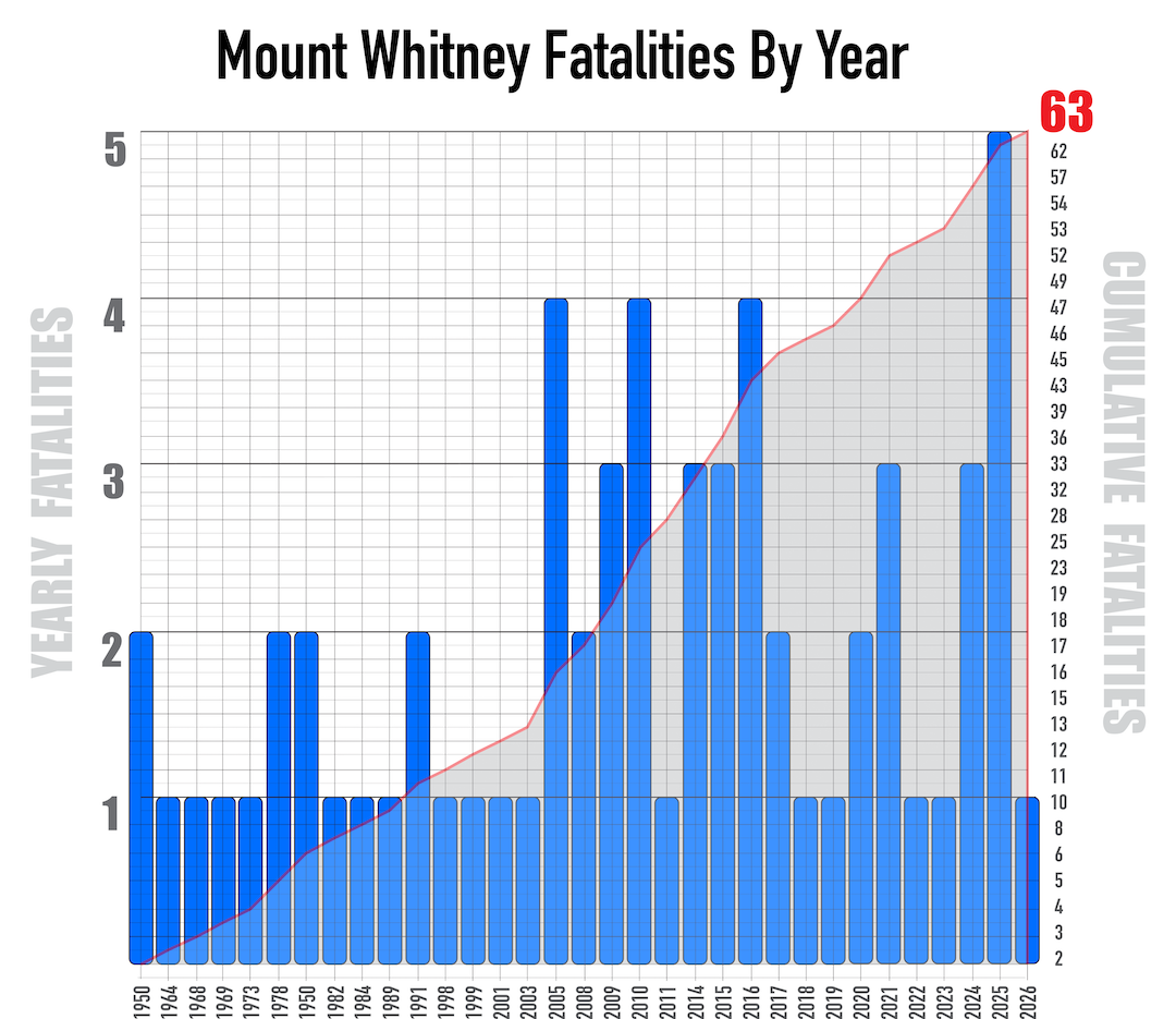
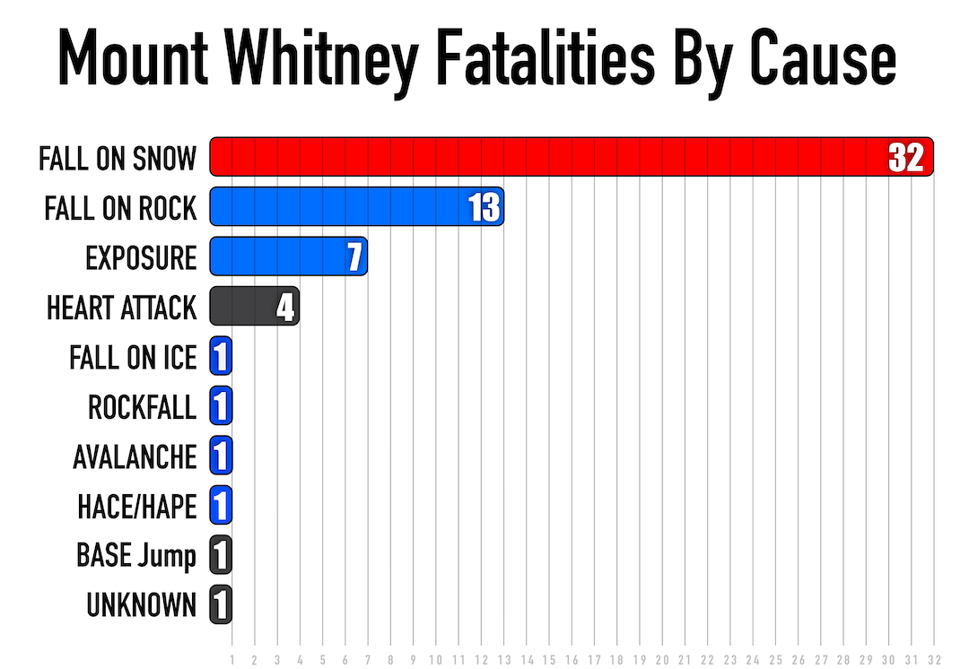
The line of demarcation between hiking and mountaineering is often poorly understood. This is a prominent and recurring theme on Mt. Whitney. The two non-technical routes—the Main Trail and the Mountaineers Route—have claimed 57 lives since reliable records were first kept in the 1950s. Six additional fatalities have occurred on the most frequented technical routes (the East Buttress [III 5.7] and the East Face [III 5.7]). Meanwhile, there have been an unknowable number of SAR rescues and self-rescues.
WHY HAS WHITNEY PROVEN SO DEADLY?
A large portion of those who suffer injury and death on Mt. Whitney did not make the mental and logistical transition between low-consequence hiking and high-consequence mountaineering. To effectively do so would require a commitment of time and energy that most cannot afford. This omission almost guarantees the failure to recognize the line of demarcation between the two. The result is the underestimation of various threats/hazards and the use of inappropriate (or nonexistent) mitigation strategies. Many have found themselves bewildered by their failure to understand the threats/hazards and how those were relevant.
Most Mt. Whitney permits are filed for the Main Trail. The remainder are a mix of the Mountaineers Route and various technical climbs accessed through the North Fork Lone Pine Creek approach. Some examples are the classic and popular East Buttress (11 pitches, 5.7) and East Face (10 pitches, 5.7), both on Whitney. In addition, The Mithral Dihedral (6 pitches, 5.10a) and Fishhook Arête (8 pitches, 5.9) on neighboring Mt. Russell are classics in the alpine-rock genre. The Main Trail and the Mountaineers Route share common risk factors while also posing their own distinct hazards.
SPECIFIC HAZARDS
Shared Risk Factors
*. Hiker-in-mountaineering-terrain phenomenon
*. The permit pressure metric
*. Truncated timelines
Main Trail Risk Factors
*. The 99 Switchbacks
*. The Slope to Climber’s Right of the 99 Switchbacks (a.k.a. the Chute)
*. Route-finding issues above Mirror Lake
Mountaineers Route Risk Factors
*. The Traverse (a.k.a. Easy Walk-Off)
*. The Final 400
*. Technical routes on the East Buttress and East Face
*. E-Ledges
*. Iceberg Lake Couloir
PRIMARY CONTRIBUTING FACTORS
Hiker-in-Mountaineering-Terrain Phenomenon
The spring and fall shoulder seasons see frequent snow cover over otherwise nontechnical terrain. This creates a heightened incident window on Whitney. The hiker community often fails to see or comprehend hazards commonly encountered in alpine terrain—and why should they? Those hazards are often counterintuitive, and hiking does not typically involve travel in high-alpine environments where the terrain is characterized by steep, snow-covered slopes at 14,000 feet.
Travel in mountain country falls well outside most people’s experience. Many have little idea of what that demands. So they arrive as hikers in mountaineering terrain, abstractly aware of hazards, but without the specific knowledge or judgment to address them. The majority of Whitney fatalities have been in unarrested falls on snow. Incorrect equipment is a frequent issue. Examples include using micro-spikes where crampons are needed; trekking poles where an ice axe is required; a hat where a helmet is needed; trekking or running shoes when more robust footwear is called for; or any combination of these.
Permit Pressure Metric
Being inside the Whitney Zone requires a permit, year-round. A quota is applied from May 1 through November 1. Most people who participate in the permit lottery don’t win one: In 2022, 115,000 people in 27,000 groups applied, but only 6,987 total permits were issued. Mt. Whitney hopefuls typically enter multiple dates during the permit lottery, and once assigned, the date cannot be changed. Also, the specific dates requested are not guaranteed—the process is random. This system, while attempting to promote a fair distribution of permits, also creates pressure to climb regardless of conditions. Erstwhile Whitney suitors might think, I may never get another permit. While this pressure is not the primary cause of accidents on Whitney, it is a subtle and powerful contributing factor.
It is no surprise that attempts are often made from May 1 to mid-June (early-season permit dates), regardless of conditions on the mountain. On occasion, aspirants who did not receive a permit sometimes attempt an ascent before the permit quota begins. Such a spring shoulder-season attempt can encompass a wide variety of conditions, all of which can fall outside conventional hiking conditions.
Truncated Timelines
Most who attempt Mt. Whitney are hikers who are drawn to the challenge of an ascent to the highest point in the Lower 48. They typically choose the John Muir Trail, known locally as the Main Trail; or less commonly, the Mountaineers Route with its 6,100 feet of elevation gain. In recent years, day hikes have become increasingly popular. The Main Trail is a 22-mile round-trip and features 6,500 vertical feet of gain/loss, while the Mountaineers Route is about an 8.5-mile round trip that offers a wide mix of steep trail, along with some exposed and highly consequential scrambling.
These are manageable figures for day hikes in dry terrain, when weather and route conditions cooperate and fitness level and terrain familiarity align with the itinerary. But most Whitney hopefuls have never been to 14,500 feet and lack experience with elevation and acclimatization—many will suffer from some degree of acute mountain sickness (AMS) due to the truncated ascent schedules that day-hike permits demand (day-hiking and overnight permits come out of the same lottery pool). The combination of AMS, inclement weather, difficult conditions, compressed schedules, fitness misalignment, and inadequate nutrition/hydration frequently leads to negative outcomes.
WHERE DO MOST EVENTS OCCUR?
THE MAIN TRAIL
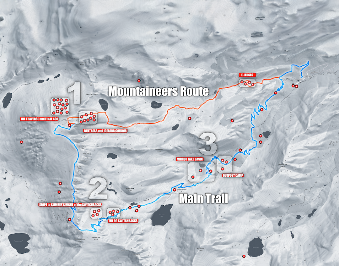
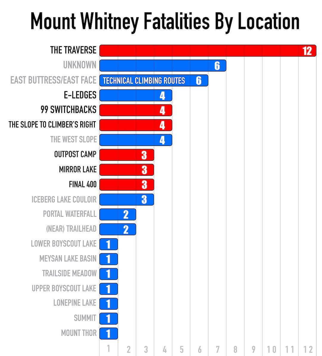
The 99 Switchbacks and the Slope to Climber’s Right | 8 Fatalities
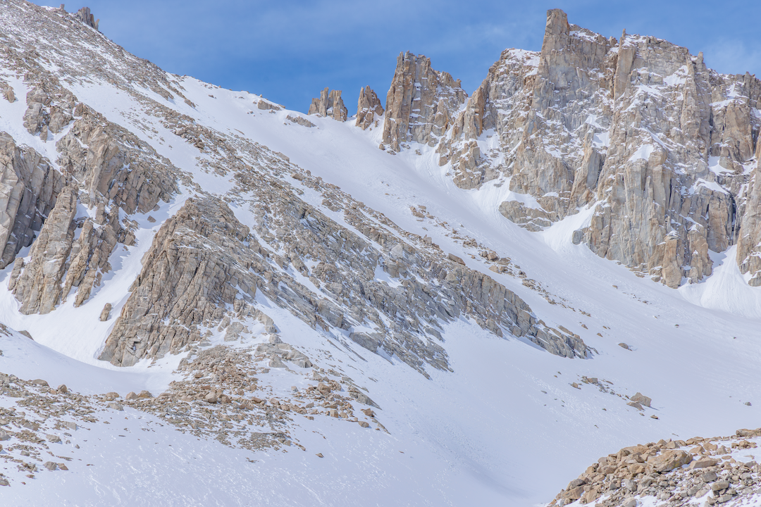
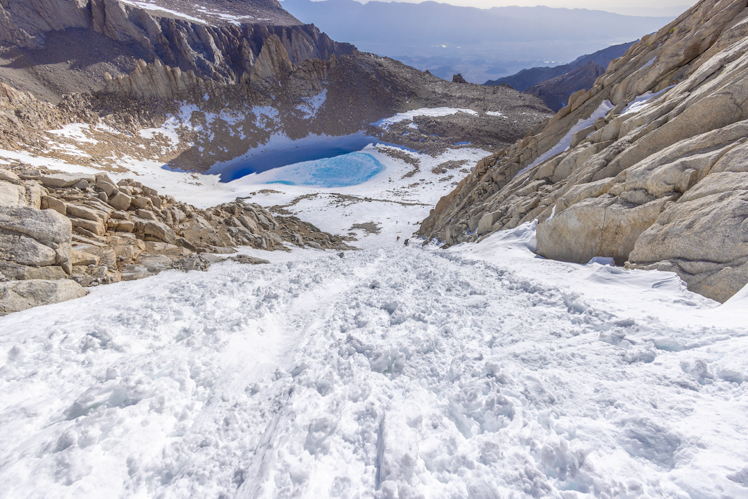
The 99 Switchbacks are an infamous feature on the Main Trail. Most people will experience this section in dry summer conditions and still find it to be the crux of the route. This long, circuitous ascent from 12,250 feet to 13,650 feet between Trail Camp and Trail Crest is undertaken by hikers who are usually already exhausted and suffering from some degree of AMS. In shoulder-season or winter-adjacent conditions, the steps can be icy, snowed in, slick, and impassable. In such conditions, the Slope to Climber’s Right of the 99 Switchbacks (a.k.a. The Chute) becomes the safest route choice and a passage that resembles classic mountaineering.
The main slope runs 35° for over 900 vertical feet. It refreezes early in the day due to its northeast-facing aspect and terrain occlusion, and is also a rockfall zone. It is frequently glissaded or attempted in micro-spikes with trekking poles and no helmet. This has resulted in falls, injuries, and fatalities among hikers who have suddenly found themselves in mountaineering terrain.
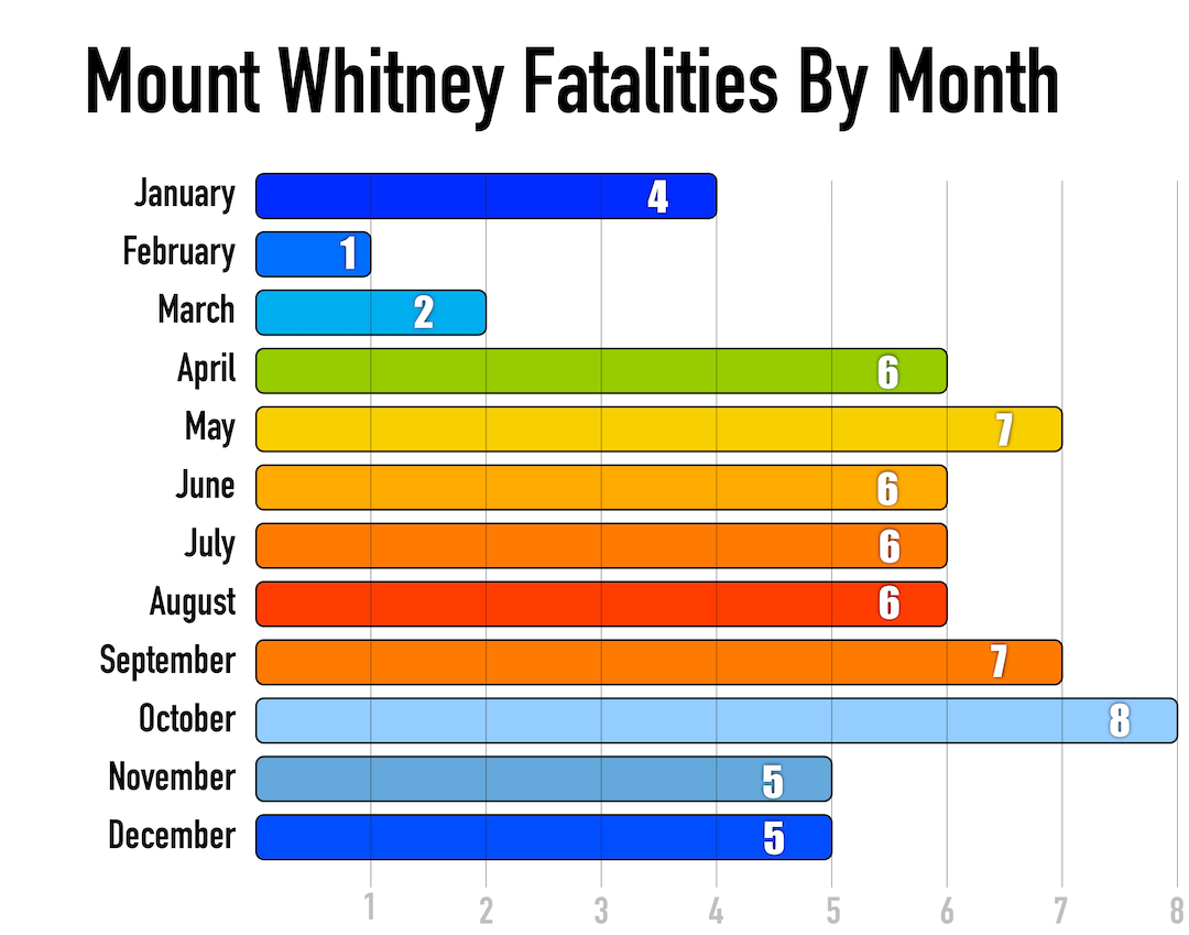
Half the fatalities and many of the rescues in the area have occurred on the actual switchbacks, attempted when fully snowed in or during shoulder-season conditions with enough snow to make the route dangerous but not enough to look dangerous to undiscerning eyes. Fatalities on both the 99 Switchbacks and the Slope to Climber’s Right have followed the same pattern: a slip on ice or névé—with or without micro-spikes—and an unarrested fall down steep bands of rock and ice.
Slabs Above Mirror Lake and Outpost Camp | 6 Fatalities
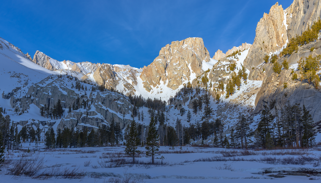
Mirror Lake sits in a granite basin at 10,700 feet below the east face of Wotan’s Throne on the Main Trail. On the ascent, the trail emerges from treeline and enters the alpine environment, before winding along an exposed granite ridge above the lake. When people return to this section after summiting late, they have been on the trail for 18-plus hours. They are often dehydrated, hypoglycemic, and exhausted. People sometimes lose the trail here, parties separate, and hikers end up cliffed out and in need of rescue; some fatally fall, down rocky chutes or snow-filled couloirs.
THE MOUNTAINEERS ROUTE
The Traverse and the Final 400 | 15 Fatalities
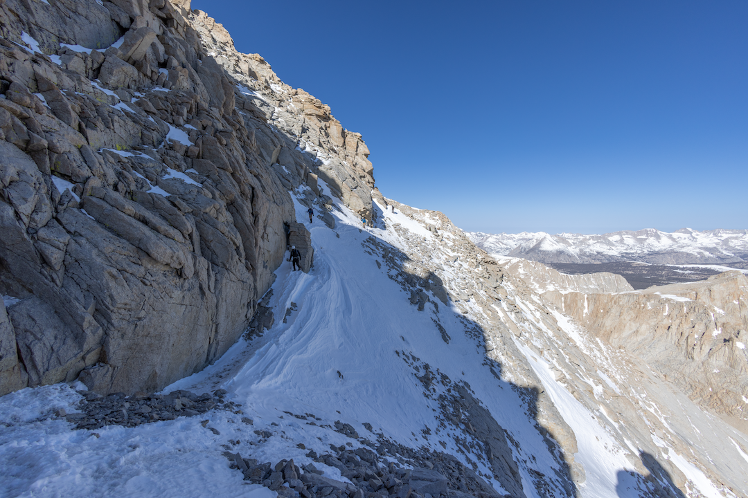
The Traverse (a.k.a. the Easy Walk-Off, or the Second Class Trail) and the Final 400 are connected both by geography and by shared hazards. Together, they represent the most dangerous place on the mountain. The Traverse is a short section above the north face. It leads directly west from the Notch at 14,100 feet. It is so named because sometimes it is used as a walk-off for the multi-pitch technical rock routes on Whitney. Many fatalities have occurred when inadequately equipped hikers and climbers attempt it when it’s snow covered.
Many reach this point and manage the mixed terrain of the Final 400, only to realize they can’t downclimb it. These hikers then choose the Easy Walk-Off, assuming it’s easier and safer. In most conditions it is neither easy nor walking. It is frequently covered with névé or faceted snow over ice, marginally arrestable at best. Both descent options are visible from the Notch, and hikers often mentally bookmark the Easy Walk-Off as the better choice. That misconception is reinforced by erroneous online descriptions and by the name itself.
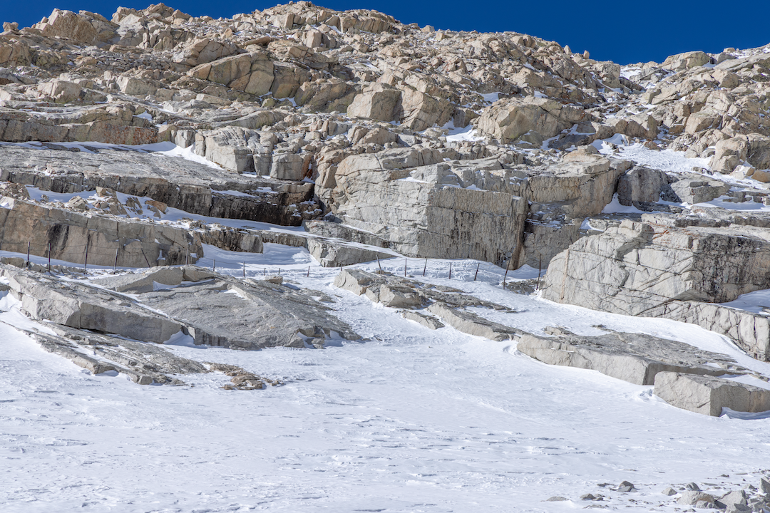
The Final 400 is the crux of the Mountaineers Route. In winter-adjacent conditions, it’s usually non-arrestable mixed terrain—firm névé interspersed with granite ledge systems, making proper crampon technique and ice-axe placement critical. When dry, the entire couloir is a river of loose rock with isolated islands of stability. Proper route-finding is imperative, and rockfall is common. All three fatalities originating within the Final 400 couloir have occurred in winter-adjacent conditions. They all began with a slip followed by a failure to self-arrest.
E-Ledges | 4 Fatalities
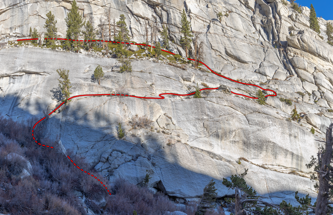
The cliff-and-ledge system at the start of the Mountaineers Route is called the Ebersbacher Ledges. These are known locally as the E-Ledges. While exposed, this section is very short and does not require technical climbing. Injuries and fatalities here have been the result of off-route falls and rockfall events.
Iceberg Lake Couloir | 3 Fatalities
There is a moderately steep (35°) couloir gaining 1,450 feet from Iceberg Lake up to the Notch. The fatalities here have been due to lost footing and failure to self-arrest in shoulder-season conditions. In the summer, the entire couloir is loose and subject to frequent rockfall.
SPECIFIC ROUTE ADVICE
THE MAIN TRAIL
Slabs Above Mirror Lake
Pre-loading a GPX route into your phone or watch can mitigate the primary factor driving negative-outcome incidents here: getting off-route in the dark and falling down a rock chute or snowy couloir. Secondary factors have been party separation and exhaustion—parties should always move at the speed of the slowest member, and never separate.
Trailside Meadow Fall Zone
There is a short section of the Main Trail directly above Trailside Meadow and just before Trail Camp that presents high-consequence exposure in a specific seasonal range. This range is the early-spring shoulder season when steep, wind-driven snowdrifts that cover the trail solidify into firm névé. Depending on when you arrive (this can be time of year and even time of day), it’s sometimes worth transitioning into crampons/ice axe/helmet.
99 Switchbacks
If the 99 Switchbacks are inundated with snow and ice, bypass them and ascend the Slope to Climber’s Right—the switchbacks are only feasible when they’re dry. If attempting the switchbacks in marginal conditions, wet, snowy, or melting out, don a helmet. It is an active rockfall zone.
Slope to Climber’s Right
Bring an ice axe, crampons, mountaineering (or adjacent) boots, and a helmet. Trying to skate through this section with micro-spikes and trekking poles multiplies the risk and has led to fatalities. Time your ascent/descent properly—firm snow on the way up, soft snow on the way down. Do not attempt to glissade marginally arrestable or mixed conditions here; doing so has led to fatalities and countless injuries.
MOUNTAINEERS ROUTE
Gully Below Lower Boy Scout Lake
In early-season attempts on the Mountaineers Route, the North Fork Lone Pine Creek gully sometimes holds enough snow to bury the trees, thus allowing hikers to bypass the E-Ledges. However, as this gully melts out, snow bridges form over the stream and trees, creating hazards like snow-bridge collapses and calving ice from the gully’s north-facing walls.
E-Ledges
While it is seldom seen, wearing a helmet in this section is highly recommended. On the E-Ledges, the mechanism of injury or fatality has often been rockfall. This is naturally triggered in specific conditions or by other hikers, higher on the route. A growing trend in rock climbing sees climbers wearing helmets on their approaches. This precaution is underscored by multiple recent fatalities that occurred while hiking to the crag.
Couloir Between Iceberg Lake and the Notch
When there is snow present, this section is standard mountaineering terrain. It will require lug-soled mountaineering boots with crampons, ice axes, and helmets. The couloir refreezes very early in the day. In some months, it never sees the sun. Time your ascents and descents to match the best conditions. When it is snow free, the couloir is a rockfall zone. Good route-finding is critical, and a helmet is strongly advised.
Final 400
This stretch requires the same hazard-mitigation strategies as the Iceberg Lake Couloir. There is an added caveat in that this terrain is frequently non-arrestable and is exposed to the possibility of unsurvivable falls down the north face. When snow is present, each party member should carry two technical ice axes. Climbers sometimes rig rappel stations here. If rappelling, inspect all in-situ tat. When it is dry, the talus blocks on climber’s right are fairly solid. If you’re pitching this section out, you can find good gear placements to climber’s left.
The Traverse
Hazard mitigation is simple: Don’t take the Traverse when it has snow and perhaps avoid it even when dry. It is loose and subject to slides and rockfall, which make it a poor option in general.
GENERAL MT. WHITNEY ADVICE
If it looks dangerous, it likely is
Turning around before terrain and conditions exceed one’s ability should be an easy decision—and yet some find it difficult. The misalignment of perceived risk versus actual danger can be compounded by inappropriate motivators. Don’t let common heuristic failures like social proof, normalcy bias, and sunk cost guide your hazard evaluation.
Mt. Whitney is a big mountain
Whitney presents real dangers and sometimes provides fatal outcomes. It is crucial to keep this in mind when facing real-world/real-time decisions. On some level, people know when they are out of their element. On a mountain like Whitney, they often disregard fear and anxiety and proceed, for all the reasons listed above—summit fever, permit pressure, “alpine brain” from hypoxia…and so on. Recognizing when one has reached their maximum risk-loading tolerance should make decisions easier. Yet, those decisions are not easy when one is blindly enamored by the idea of standing on the summit of the Lower 48’s highest peak.
When significant snow is present, Mt. Whitney is not hiking—by any route
With snow, Whitney becomes a mix of hiking and real mountaineering. For attempts on the Main Trail or Mountaineers Route, this often means engaging in just that: classic mountaineering. In very general terms, during the spring shoulder season in the Sierra Nevada, Mt. Whitney involves hiking below the treeline and classic mountaineering above it. The spring shoulder season will sometimes run into July. Trail Camp (Main Trail) or Iceberg Lake (Mountaineers Route) is where the line of demarcation becomes consequential. A successful Whitney attempt by either route under these conditions means addressing the physical, mental, and technical requirements of hiking and classic mountaineering.
Track your caloric requirements and hydration needs
It’s very common for Whitney suitors to underestimate and/or neglect their hydration and caloric needs. This becomes more prevalent at elevation. It takes time and experimentation to determine your average hydration and caloric consumption rate per hour across varying terrain and conditions. Removing the guesswork pays huge dividends. From initial mission planning to execution, understanding precisely how to fuel your endeavor—given distance and elevation gain and the nature of the environment—is an asset that could save your life.
CONCLUSION
Is Mt. Whitney “just a hike”? In the mountains, simple questions have complex answers. It’s never cut-and-dried. What is simple is this: When aspirants approach and treat Whitney only as a hike, they are often injured or killed. Mt. Whitney occupies a dangerous place in social lore: The mountaineering community largely ignores it, while the hiking community puts it on the bucket list. Hiking season frequently overlaps with mountaineering conditions on and in terrain that any mountaineer would immediately recognize as perilous and potentially fatal.
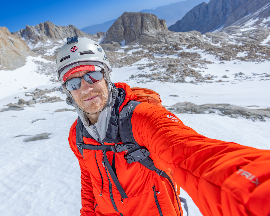
The influx of new hikers is outpacing the mountaineering community’s ability to moderate it through mountain-safety outreach. People don’t know what they don’t know and can find themselves in terrain they don’t fully understand. The results can be tragic.
Author Bio: Brandon Riza is an alpine climber/technical mountaineer, ski mountaineer, and mountain ultrarunner, with 25 years of experience in the Sierra Nevada, Cascades, Alaska Range, Andes, French Alps, and Swiss Alps. He is a technically oriented mountain-safety-outreach advocate, an administrator of the Mt. Whitney Facebook Group, software developer, pipeline technical director in the visual effects industry, photographer, and artist. He is currently based in Southern California and spends lots of time throughout the Sierra, frequently on or near Mt. Whitney.
Media Gallery