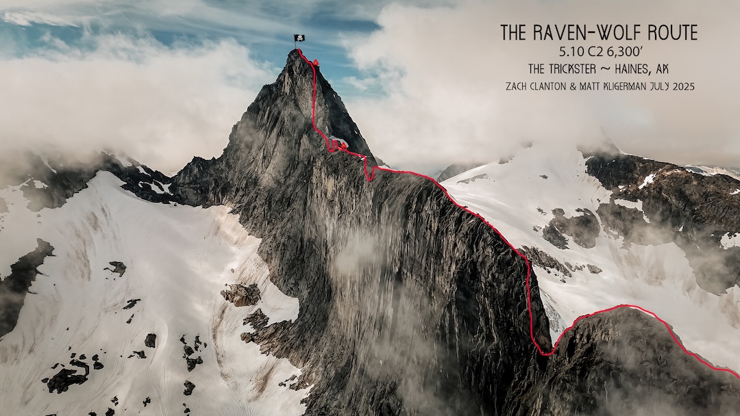
The Trickster, The Raven-Wolf Route
Alaska, Coast Mountains, Boundary Ranges
During the summer of 2024 in Haines, Alaska, three separate people told me I needed to climb with Zach Clanton. Zach reminds me of a modern-day Indiana Jones. He searches Alaska and British Columbia for mountain treasure: aesthetic, unclimbed rock faces that have hidden in obscurity. He has built a decade of friendships with bush plane and heli pilots who bring him rumors of mountain faces that briefly appear through the clouds. When he spotted the Trickster in the distance through a zoom lens during one scouting mission, Zach knew he had found something special.
The Trickster (5,821’, 59.160675, -135.110847) rises above unnamed hanging glaciers about 13 miles southeast of Haines. Our objective was the half mile-long east ridge, culminating in a steep granite headwall. Dick Ellsworth and John Svenson had climbed the Trickster from the west, along with nearby Termination Peak, back in January 1982, approaching from tidewater. (See notes below.) In the 40-plus years since, no one else was known to have attempted the mountain.
In the early summer of 2024, Zach and Taylor Brown flew in to attempt the east ridge. There was a ton of snow, and they decided not to risk the avalanche danger getting to the ridge. Zach and I decided it was worth giving the route a go the following year, a bit later in the season.
I flew to Haines from Boston on July 9, 2025. A rare weather window appeared to be opening in a few days. We got to work buying food and prepping gear, a challenging task given the varied terrain (glacier, snow, and rock) and the unknowns of the route: Would the climbing be moderate or 5.12+? Tiny cracks or wide cracks? Light and fast or big-wall style?
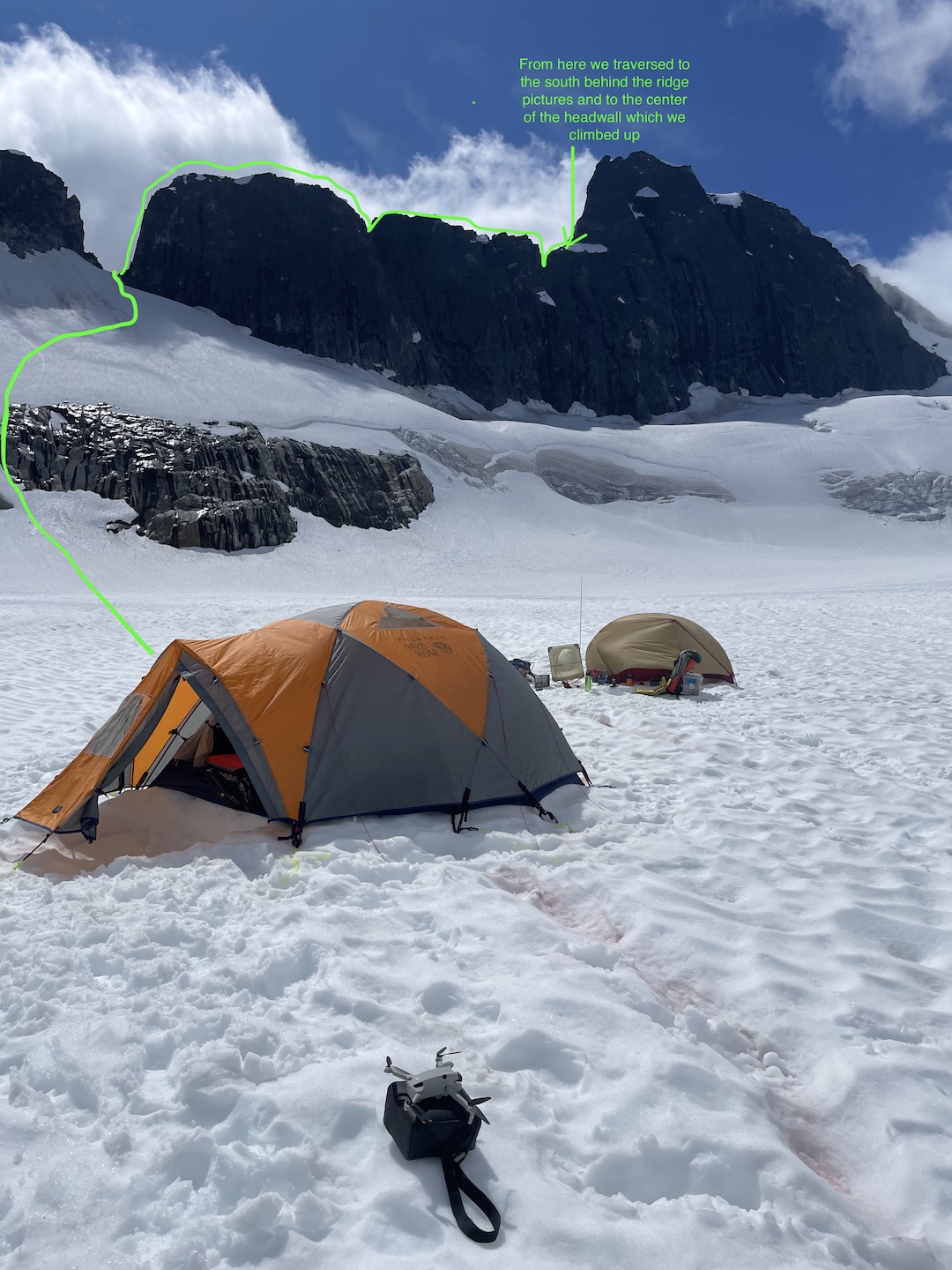
Our plan was to fly in with a bush plane and land on the unnamed glacier northeast of the Trickster that Zach had dubbed the “Peyote Glacier” after his dog, Yote, who camped there in 2024. However, the pilot was booked until midway through the expected weather window. After a brief period of despair, we connected with heli pilots at Temsco who worked magic to fit us into their schedule. Initially they seemed quite worried when we told them we wanted them to leave us on a remote hanging glacier a couple of thousand feet above the valley and that we’d satellite text them in about a week when we were ready for pickup. But after we assured them we were taking two weeks of supplies to wait out a bad storm if needed, they agreed to partake in the unusual mission.
On July 13, Zach and I took an early-morning ferry to Skagway, then packed a couple of hundred pounds of gear into every nook and cranny of the Hughes 500, piloted by Sitara Mohr. After we were dropped on the Peyote Glacier, silence and stillness surrounded us. Since it was only midday and we wanted to take advantage of every bit of good weather, we decided to begin our climb immediately.
We formed a plan to climb a 1,300-foot snow slope up to a notch in the Trickster’s east ridge, start up the rock wall above the notch, then stash an alpine tent, food, and gear before descending to our glacier camp to wait out some bad weather. Then we’d regain our high point, claim our stash, and climb onward to the terminus of the ridge. We hoped to find a somewhat flattish camp as close to the headwall as possible. From there we’d blast off for the headwall push and up the final summit ridge. We brought gear for mostly free alpine climbing, minor hauling, and a light aid rack.
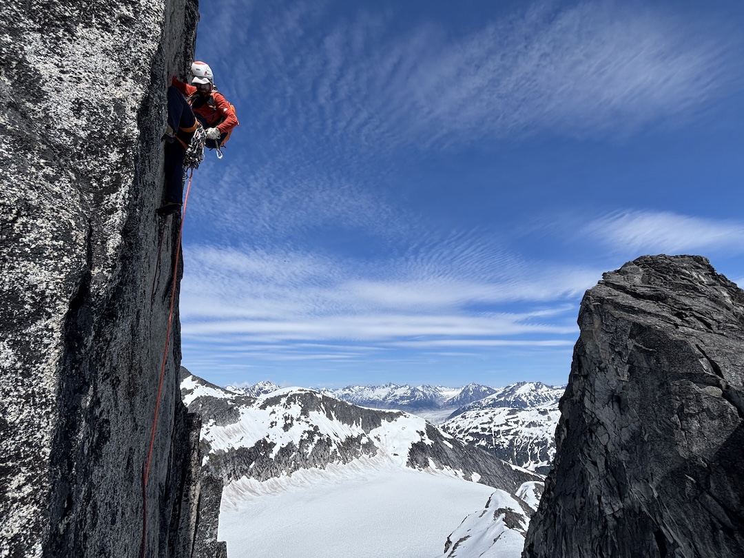
With crampons and axes, we climbed the snow slope leading up to the notch in the ridge. A nearly vertical rock wall rose above the notch. Looking up at it, we realized we had lucked out, as several beautiful splitters greeted us. Zach tackled the first pitch, with 5.10 climbing through offwidths, flaring finger cracks, gritty uncleaned granite, and loose rock. After fixing lines, Zach rapped down to the col and we cached an alpine tent and our gear before descending to camp for dinner. The glacier, which had been like a gigantic frying pan with the sun out, turned frigid cold as nightfall arrived and the wind whipped up.
The next morning, we carried a second load of gear up the snow slope to the col. From our high point on the rock wall, we swung leads up three more pitches on beautiful granite to reach the ridge crest, where half a mile of fun alpine terrain would take us to the headwall. A hummingbird darted over to us on the ridge—we took it as a nice sign.
Back at camp again, we prepared for an incoming storm, cooking a speedy dinner and ducking into our cozy tents as the wind arrived. All the next day we rested, refueled, and sharpened our strategy.
After an egg and sausage breakfast to begin our fourth day in the mountains, we reclimbed the snow slope and jugged our fixed lines. The ridge traverse was mostly 4th-class terrain with amazing exposure on both sides. It felt like Zach and I were dragon riders in another world, crawling along the snaking spine of a colossal creature, grabbing scales of rock, flying through the clouds, searching for treasure, and hoping to sneak out before we were noticed.
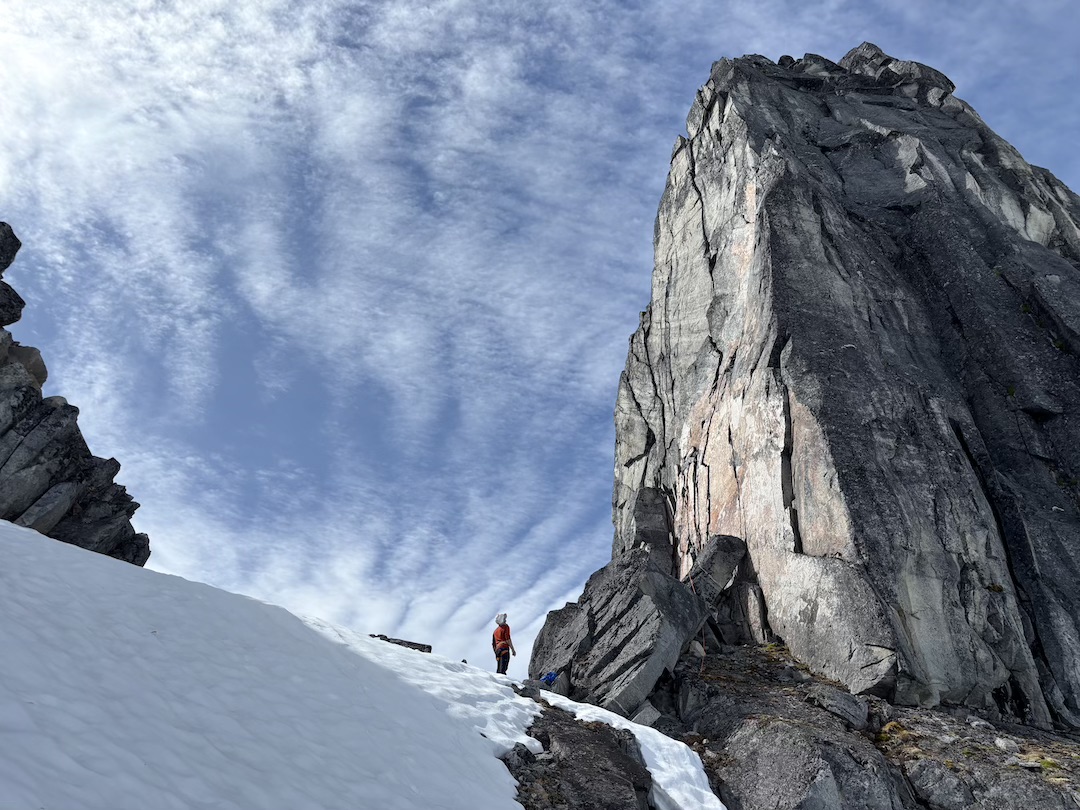
A couple of large gaps in the ridgeline required rappelling down one side and then climbing rotten 5.8 rock back up the other side with heavy packs. During our second rappel, I accidentally knocked off a football-sized rock that landed squarely on one of our ropes, cutting it right in the middle. We would have to make do with a single full-length dynamic rope.
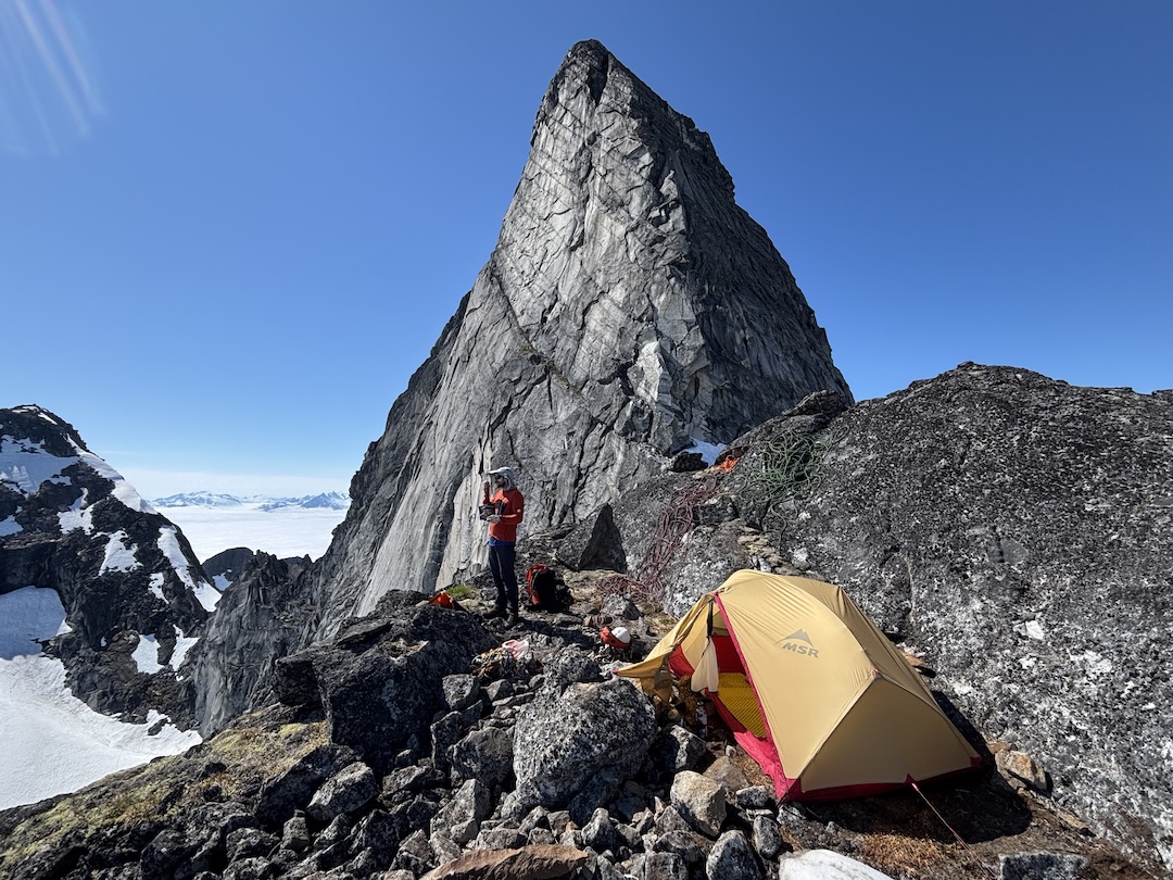
We kept simul-climbing along the ridge, looking for a spot to make a high camp that was relatively flat and with snow we could melt for water. Our hummingbird friend darted into our lives once again along the ridge. The farther along the ridge we got, the larger the headwall loomed; we had started calling it the Isabella-Luke Wall, for the two young ones about to enter my life back home. At the very end of the ridge, we found a perfect perch to make camp, dug out a tent platform, and boiled snow for water.
The next morning, we rappelled into the col that separated the east ridge from the headwall, leaving a 40m static line fixed for our return. Zach led two rope-stretching pitches out of the gap, moving left toward the crack system we hoped would grant passage up the headwall. Our hummingbird friend flew over and visited us one last time, raising our spirits.
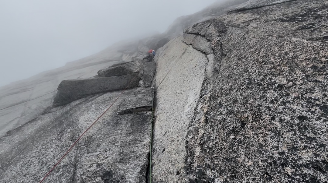
Zach took the first lead up the headwall, following a nice finger crack system. Halfway through the first lead of my block, the crack pinched into a shallow, flaring, slightly overhanging, moss-filled finger crack. I switched into aid mode, got out my nut tool, and started digging. After a handful of offset nut placements and flaring cams, I was able to continue free climbing.
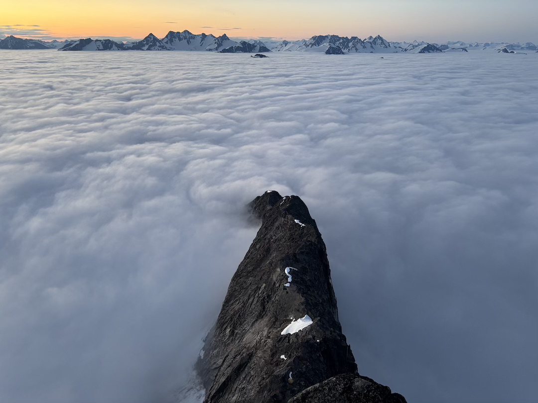
The difficulties kept coming, but each time we found a solution: a blind reach over a bulge for a jug; another 60 feet of mossy aid climbing, followed by a transition into 5.10 free climbing around a bulging arête; an exposed face traverse to avoid a refrigerator-sized block. By now the marine layer clouds that had rolled in the prior evening had risen and fully enveloped us. We were climbing in a cold, damp, windy cotton ball, only able to see a hundred feet ahead at a time.
Near the end of the fourth pitch on the headwall was an obvious exit chimney, but as I prepared to pull into it, I noticed fridge-sized boulders inside, leaning against one another like a tower of cards. I looked at some cracks out to the right—mossy, flaring, and significantly overhanging. I looked left into a roof system and swirling clouds. I looked up into the chimney again—the stacked blocks did not seem any more appealing. I decided to head out left. Fortunately, cracks kept appearing through the tiered roofs, and with a mix of 5.10 climbing and pulling on some pieces, I pulled onto the top of the headwall.
I belayed Zach up, we high-fived, and he quickly raced ahead—we still faced about 800 feet of exposed 5.7 ridgeline. Simul-climbing, we pulled out of the clouds and into glorious rays of sunshine for the final few hundred feet to the summit.
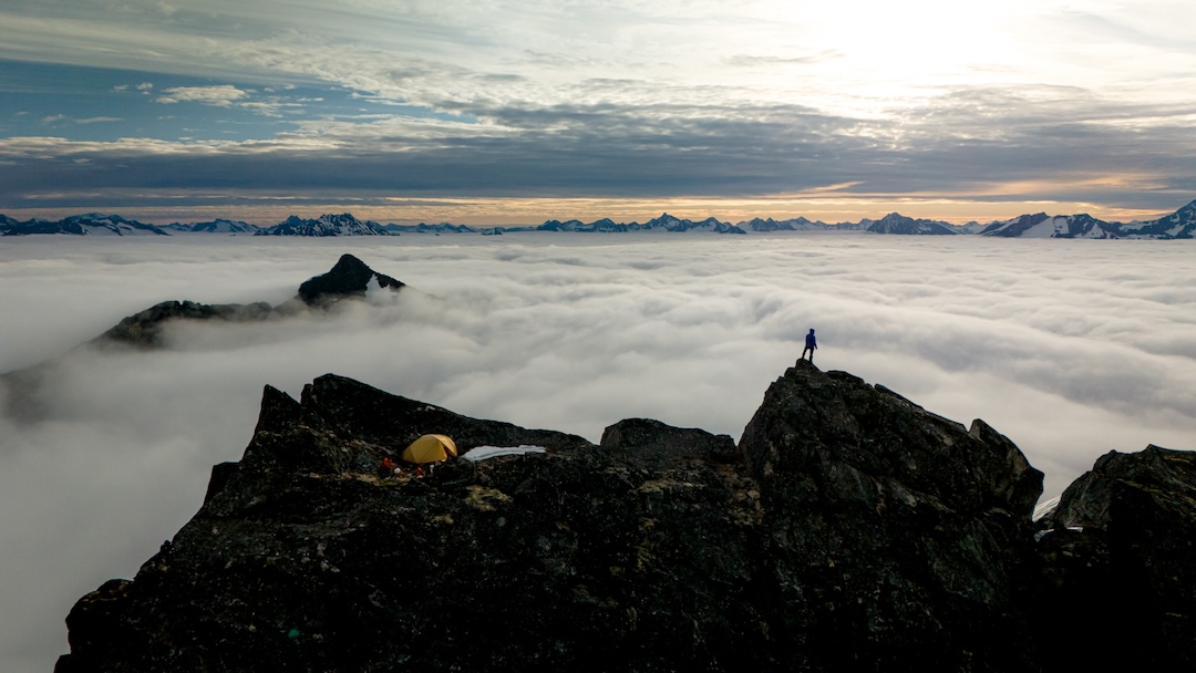
After taking in the 360-degree views and the warmth of the evening sun, we simul-downclimbed back to the top of the headwall. It was getting late, and when we discovered a plush bivy spot with a bed of moss, we decided to tuck in for an open bivy rather than rappel the headwall in the dark. The cold woke us both after just a few hours, and we spent the rest of the night alternating between squats and lightly sleeping.
The morning sunrays lit up the magical clouds that had sunk below us once again. I unclenched my hands that had fused together during the tense cold, and we prepared for the first rappel down the headwall. Zach led the way, building rappels and navigating safe passage for us down the face. With a butterfly in our damaged rope, we were able to use both ropes and streamline our descent.
At the bottom of the headwall, we downclimbed three traversing pitches, rappelled into the col, and jugged up the fixed line to return to our high camp and much-appreciated freeze-dried biscuits and gravy. The forecast showed another day of good weather, so after confirming the heli could pick us up on the glacier the following day, we decided to milk the best campsite on earth and enjoy the views for another evening before continuing down to base camp and a heli ride back to town.
When we had flown into the mountains, only a handful of people had known our intentions, but news had spread in the small town while we were away, and as we walked down the streets with our backpacks, several seasonal guides and heli pilots came over to give us high-fives for our success. I’m grateful to the mountain gods that granted us a weather window, safe passage, and the adventure of a lifetime. We named our line The Raven-Wolf Route (5.10 C2).
—Matt Kligerman
First Ascents of Termination Peak and the Trickster: The Trickster and Termination Peak, just to the north of the Trickster, both were climbed in the winter of 1982 by Dick Ellsworth and John Svenson. The following account is based on correspondence with the two climbers by Alaska climbing historian Steven Gruhn and was published in the May 2010 edition of The Scree (Mountaineering Club of Alaska), reused here with permission.
In January 1982, Dick Ellsworth and John Svenson took a boat from Haines to a point about 4.5 miles southwest of Termination Peak (ca 6,150’, 59.170914, -135.117331). Ferrying loads after leaving the boat, they zigzagged and post-holed up the 45° slope for 2,000 feet to reach a high basin with three lakes in it on the second day. From there, the two attained 5,150-foot Frogleg Pass on their third day. From the pass, they descended to the right and turned left upon reaching the flat of the glacier below. They hiked northeast about 2.5 miles down the glacier and climbed to the crest of the southwest ridge of The Trickster.
From their bivy site at about 5,100 feet on the southwest ridge of the Trickster, they descended to the unnamed glacier to the north and climbed the southwest slopes of Termination Peak to its northwest ridge and from there to the summit. Upon reaching the summit, the duo figured they had terminated their resources, named the peak accordingly, and returned to the coast for a boat pickup, climbing the west face of the Trickster and descending its southeast slopes while en route. They subsequently named Frogleg Pass for the unusual cuisine eaten during their bivy.
Media Gallery