

Nangpai Gosum I, Southwest Face via South Summit
Nepal, Mahalangur Himal, Khumbu Section

At 10:24 a.m. on October 3, I reached the summit of Nangpai Gosum I (7,321m, see editor's note below) all alone. This peak on the Nepal-Tibet border, southwest of Cho Oyu, had been considered the fourth-highest unclimbed mountain in the world. As far as is known, prior to 2017, it had had only two serious attempts. In 2006, Kazuyoshi Kondo’s joint Japanese-Nepalese expedition fixed 2,600m of rope up the south ridge to reach what they referred to as the 7,240m south top. Despite the relatively early hour (11 a.m.), the team did not continue across a plateau to the main top, which looked quite far. A direct line up the south-southwest face, overlooking the Lumsumna Glacier, was attempted by four French guides in October 2016. After a bivouac at around 6,200m, they progressed to about 6,600m, where one of the team, Mathieu Maynadier, was hit on the arm by falling ice and injured (despite good conditions, every team member was hit by either ice or rock) and they retreated.
After acclimatizing in the region, I arrived in base camp on September 5, and over the next few weeks carried loads, including 500m of rope, to the base of the mountain. My idea was to fix these ropes on the very technical passages of the French line, so that they would only have to be soloed once; they also would allow a quick descent in case of bad weather or injuries.
 One of the problems with this route is its south-facing orientation: Once the sun is up, the ice melts quickly, exposing granite. This not only makes the climbing difficult but also sends down a bombardment of rock. If it is snowing, avalanches regularly crash down the line.
On September 25, I tried to reach the French high point to establish my Camp 2. During my attempt, I soloed an 80° ice wall at ca 6,300m and then faced very dry conditions in the upper section, where there was a bottleneck (climbed by the French in 2016 and estimated to be M6/6+). There was no other option, but the ice was very thin, fragile, and ended on blank stone. To get an overview and hang my backpack, I built a temporary anchor from two ice axes and an ice screw. As I began to hammer in a piton, the entire belay ripped, leaving me hanging from the piton, which was only half in. The sun had been so intense it had quickly melted out the ice screw and axes. I decided to retreat. I’d felt safer when I climbed Annapurna, considered one of the world's most dangerous mountains. I reached my Camp 1 at 6,100m in the middle of the night. Screws had melted out, ropes had been cut by rockfall, and I got hit several times and was lucky not to be seriously injured—what a day!
Back at base camp, the staff were preparing to leave. But I couldn’t let go until I felt I had tried everything. I opted for another attempt, farther right, close to the Japanese line from 2006. I went light and fast, leaving most of my equipment, including any rope, at the base of the mountain. But I did take a harness in the unlikely case I needed helicopter rescue.
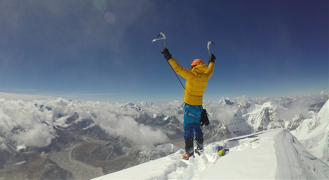
Starting from advanced base (5,600m) at 3 a.m. on October 1, I slanted up the southwest face of the south summit to a campsite at 6,400m (40–50° at the start, rising to 60–70° toward the end), and then the next day up to a second camp at 6,840m (50–55°). I left this camp at midnight and climbed through the night (generally 50° but with two short vertical sections). At the plateau beyond the south top, I struggled through almost waist deep powder, but I reached the main summit midmorning. Wind gusts up to 60 kmh (37 mph) made my stay short, but for a brief moment I stood still and felt like one of the adventurers I’d read about as a child. This wasn’t following somebody's footsteps—it felt so much bigger than my previous climbs. When I returned to base camp I found only my photographer, Raphael Schardt, waiting for me with a single tent.
Jost Kobusch, Germany
Editor's note: The Nangpai Gosum peaks lie on a high ridge forming the Nepal-Tibet border, and confusion surrounds their nomenclature. Originally, the most westerly of the peaks with this name, dubbed Nangpai Gosum I, was the 7,350m summit immediately north of Dzasampatse (6,295m). It was also known as Jasamba or Jasemba. However, in 1993 the Ministry of Tourism renamed this Pasang Lhamu Chuli, after the first Nepalese female to summit Everest (she died on the descent). Much later, on the recommendation of the Nepal Mountaineering Association, the ministry renamed the group so that Nangpai Gosum I now became the 7,321m peak (formerly referred to as Nangpai Gosum II or Cho Aui) immediately east of Pasang Lhamu Chuli. The name Nangpai Gosum II (7,287m, sometimes referred to as Chamar) was given to a less distinct top further northeast. The official HMG-Finn map, the Himalayan Database, and recent entries in the AAJ all use this newer convention for Nangpai Gosum I and II, as did the 2006 Japanese expedition. In the 2017 Ministry of Tourism guide, the coordinates given for Nangpai Gosum I and II are more or less correct for peaks 7,321m and 7,287m. However, their heights are given, respectively, as 7,350m and 7,307m. In this report, we maintain the same nomenclature we’ve used in the AAJ over the last 10 years.
Media Gallery


