

At Bashi Ski Mountaineering
Kyrgyzstan, At Bashi Range
The At Bashi Range is particularly suitable for ski mountaineering and still has around 60 peaks above 4,000m that remain unclimbed. In 2016 our team explored the potential in the heart of the massif, which contains the highest peaks, and learned that it is too far to reach in one-day trips from a base at At Bashi town (AAJ 2017). For our next trip, therefore, we planned to operate from a yurt camp in one of the side valleys, and we chose the Tuyuk Bogoshti, which flows north down to the village of Birinchi May (“May 1”). Using horses, our agency planned to establish the camp in a clearing at ca 2,800m. For medical reasons, last year's leaders, Sonja Brambati and Paolo Vitali, were unable to accompany us, so the team was Daniele Bazzanella, Franz Carrara, Andrea De Finis, Mirco Gusmeroli, Giulia Meregalli, Fedorino Salvadori, Emanuele Zuccotti, and me.
We arrived in At Bashi on April 3 and the next day went to examine snow conditions. They were bad: There was far more snow than in 2016, and it was wet with no crust, due to the previous few weeks of uninterrupted cloudy weather. On the 6th we visited our yurt camp and were disappointed to find it located at 2,400m, about 5km down valley from our proposed site. But it was comfortable, with beds, mattresses, blankets, and the yurts heated by coal stoves.
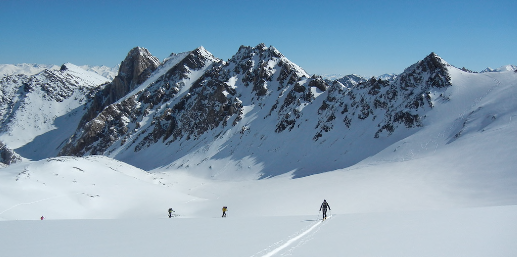
The weather improved. We managed to ski on the 7th, and on the 8th we reached our first summit. Leaving at 7 a.m., we moved south up the Tuyuk Bogoshti and then took an eastern tributary, eventually reaching the high glacial valley of Kok-Moinok, which allows access to a dozen summits over 4,000m. Fatigue and the late hour (it was already 1 p.m.) made us opt for the closest top, which we reached via its west slopes and south ridge. We named it Choku Bocia (4,135m, 41°4'43.86"N, 76°5'2.11"E). We then made a fine ski descent, reaching the yurts at 5:30 p.m.
Having ascended and descended 1,800m, we felt justified in having a slightly easier day on the 9th, and we headed up a ridge on the western side of the Tuyuk Bogoshti that appeared to lead to a high point of 3,400m, quite far enough for the day. However, there was a "problem." Once there, we could clearly see an easy continuation leading to a higher top of 3,750m. Of course, we had to do it. Later, we found that the locals call this summit Choku Kuumamy (41°6'21.76"N, 76°1'9.15"E). We made another fine ski descent, the first from this summit, to the doors of our yurts.
We had to be in At Bashi town on the night of April 10. That day, we set off at 4 a.m. and again reached the Kok-Moinok Glacier and continued to its head. From there we climbed up to the watershed ridge and, moving west, reached a narrow summit of 4,256m, our highest during the expedition. We named it Choku Sonja(41°4'24.60"N, 76°4'25.00"E) after our friend (SonjaBrambati), who could not be with us. It was a full 12km descent on skis to our camp, which we found already dismantled and loaded into a lorry that was waiting to transport us to At Bashi.
Back in Bishkek, Vladimir Komissarov, president of the Kyrgyz Alpine Club and the Kyrgyz Mountain Guides, and author of the most detailed overview of the mountaineering regions of Kyrgyzstan, informed us that while Choku Kuumamy had been climbed previously, our other two peaks were first ascents.
– Ruggero Vaia, Italy, supplied by Paolo Vitali
Media Gallery


