

Chhogo Valley, T16, South Summit, Southwest Face; T13, Northwest Ridge, Attempt
India, Zanskar

Working with a report in the Japanese Alpine News by Kimikazu Sakamoto and some Google Earth imagery, but with limited information on the peaks we hoped to climb, we decided to plan a low-budget summer expedition to the Zanskar Range. Sakamoto’s report was invaluable for making sense of an area where the Indian Mountaineering Foundation (IMF) listed only code names, altitudes, and GPS coordinates.
We were joined for the acclimatization portion of the trip by two Indian friends, Prerna Dangi of Delhi and Karn Kowshik of Pune. After the mandatory paperwork in Delhi for our intended objectives (T13 and T16, as designated on the Sakamoto sketch map; see AAJ 2013), my wife, Cristina Pogacean, Prerna, and I traveled by public transport to Padam, where we met Karn, who had driven with some of the luggage.
On June 8, after a two-day trek via the Chhogo Tokpo, we established base camp on moraine at 4,900m, at the entrance to a small side valley rising southeast between the T16 and T13 massifs. Three days later we all set off for the northwest ridge of T13 (6,436m), our planned acclimatization climb. Tricky snow conditions after midday and lack of information about what was in store caused us to turn back from the long and complex ridge at around 5,900m. Satellite imagery had led us to believe T13 would offer easy lines, but reality showed this was not the case. However, the climb presented a good view of the southwest face of T16 (6,431m) and an obvious route: a beautiful, natural couloir running from bottom to top.
On the 14th, after two days of rest and a gluttony competition, Cristina and I camped 2.5km up-valley to the east at around 5,200m. We started up the couloir early next morning. It was pretty straightforward, as we expected, with a couple of short-lived 75° sections. The early start allowed us decent névé, and the going was fairly relaxed. We simul-climbed nearly all of it, with a short brewing and breakfast stop on a ledge halfway up. We were hoping to get off the snow and into a sheltered spot before the sun hit the couloir, as we were anticipating slush and rockfall.

The snow section of the couloir ended with a constriction and a foretelling of what was to come, with 5m to 7m of rotten ice and polished rock. By the time we were done, the sun was more or less upon us and we scurried to find a sheltered place to bivouac. Due to rockfall, climbing would not be possible until evening. We were both queasy and sun-struck. Conversation was merely functional, with a tint of irritation. As we went to sleep I said, “At least it’s not snowing!” It wasn't longer than half an hour before the first snowflakes danced onto our bivouac bags. My wife told me, quite justifiably, to shut up.
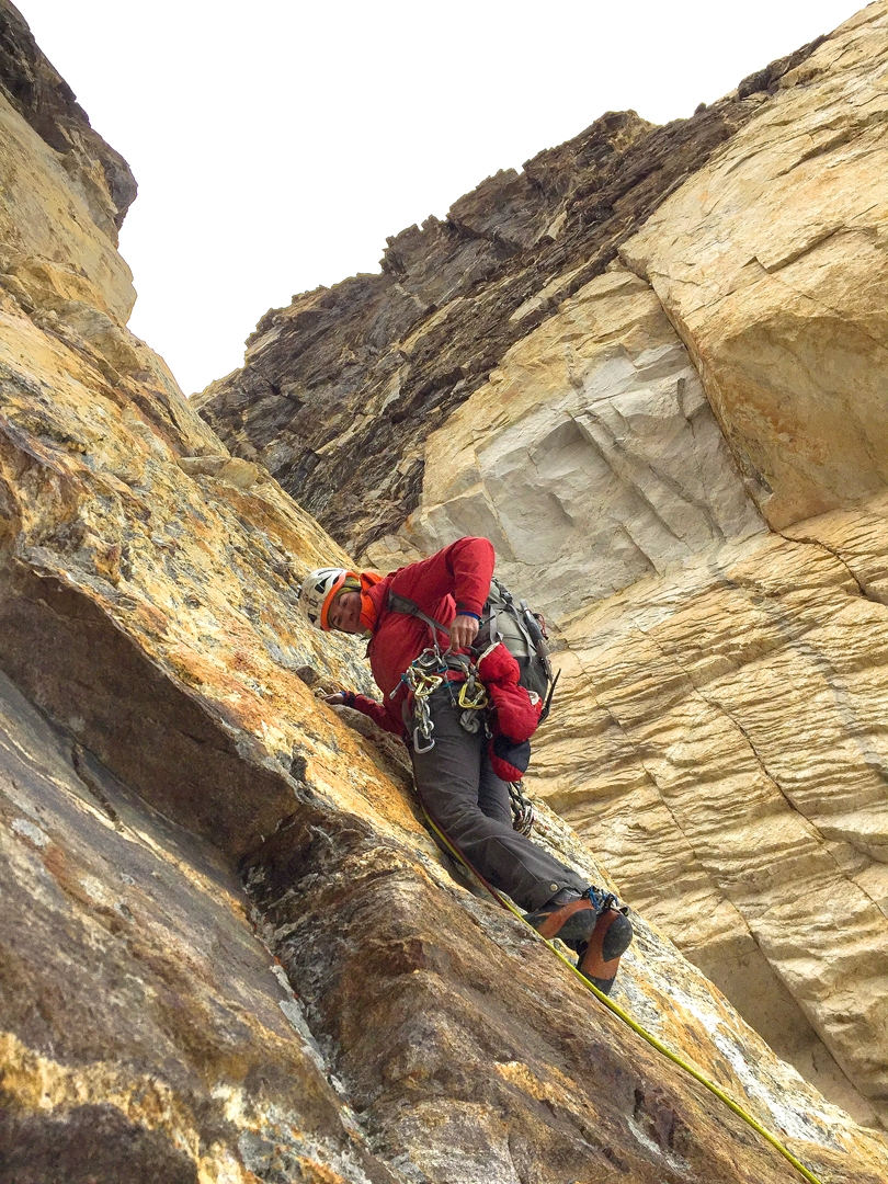
Next day the cruxes were long: a 60m pitch of poor ice and a poorly protected mixed pitch of the same length. Fortunately, everything else that day was moderate. The site we excavated that night would have been good for one person, if he or she were small.
On the 17th we left most of our gear at the bivouac site, and after a few wet, snowy pitches on decent rock, but with fingery moves, we ended up on a beautiful face. The sun was out, the rock was dry, protection about right, and we were able to climb in rock shoes. We soon passed the false summit, a white triangle visible from base camp, on the right, by its east face. The climbing became better and better, and close to the exit onto the final ridge we experienced some of the best rock climbing either of us had done in the high mountains.
After a while we could not be bothered switching out of our rock shoes in order to negotiate the snow bands, and at the base of the final arête we left behind the rucksack and big boots. This arête was the meeting point of several ridges, including the two sides that bordered our couloir. The ground ahead looked moderate, and we could see the flat, tabletop northern summit of T16 ahead and the south summit directly above. It was already past 4 p.m. and we were feeling a high sense of urgency. The north summit was at least a kilometer away, and the connecting ridge meandered up and down with a number of pinnacles. As we were not keen on hopping on each and every one of them, nor planning to tag the north summit (especially since we had no idea which summit was the higher—IMF records only give one height for T16), we stopped at the south top (33°22'45.57"N, 76°48'17.15"E, Google Earth).
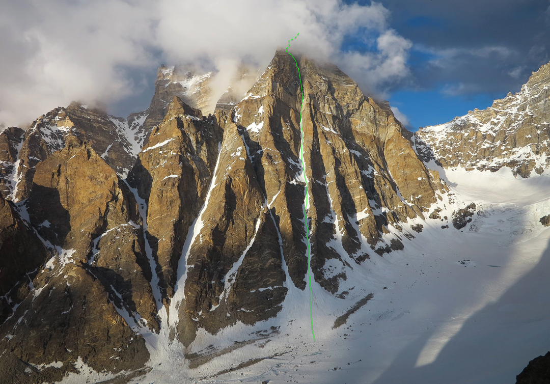
Well after 5 p.m., we began heading back, downclimbing where we could and rappelling where we couldn't or thought it would be faster. We collected our gear at the top bivouac and continued into the night, rappelling past the first bivouac and into the snow couloir. At first downclimbing, then alternating between climbing and rappelling, we eventually walked out onto the glacier. By 3 a.m. we were in base camp with a hot mug of chocolate. Sleep was never sweeter, nor the sleeping bag softer. We have named the 1,200m route Supercouloir (ED, 6b C1 WI4+ M5/6 75°). [Editor’s note: More photos from this expedition can be seen at the author’s website.]
Cosmin Andron, Romania
Video by 4play.in.
Media Gallery


