Mukumbarí Integral Link-up
Venezuela, Sierra Nevada de Mérida
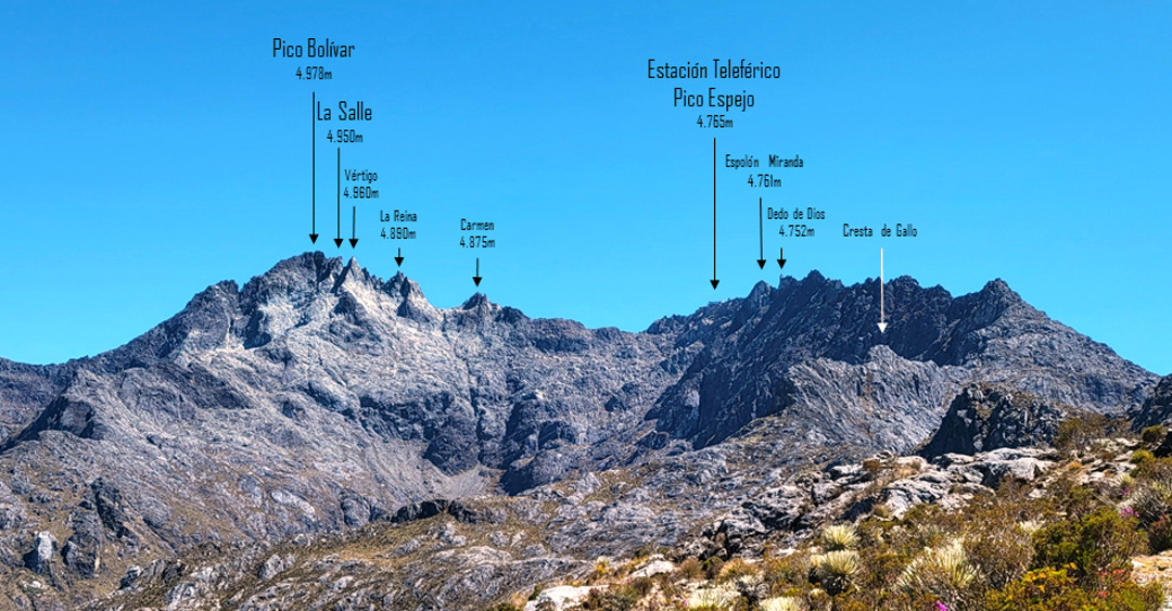
Situated southeast of Mérida in far western Venezuela, the Sierra Nevada holds the country’s highest peaks, culminating in Pico Bolívar (named after Simón Bolívar, the Venezuelan military officer who liberated many South American countries from Spanish rule). Historically, the altitude of Pico Bolívar was recorded at just over 5,000m, but more recent calculations have decreased the heights of most peaks in the range, and Bolívar now stands at 4,978m (8°32’28.15”N, 71°2’47.51”W).
The range is also notable for having the highest cable car in the world. Known as the Mukumbari, it rises from the city of Mérida (1,600m) to Pico Espejo (4,765m) through the complete spectrum of Andean vegetation.
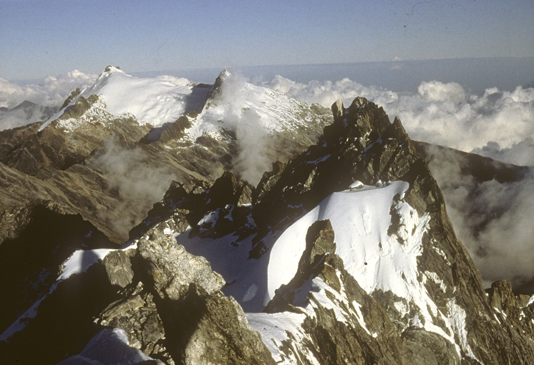
The Sierra Nevada has been dramatically impacted by climate change. Even in the 1980s, melting had reduced the range’s glaciation to only two glaciers on Bolívar and two on Pico Humboldt (4,919m), the second-highest peak and most easterly major summit in the range. By 2009, only a Humboldt glacier—La Corona—remained, and by 2024 it had shrunk so much it was downgraded to an “icefield,” making Venezuela the first Andean country to lose all its glaciers. Ostensibly to protect Humboldt’s vanishing ice mass, the government forbids climbing on both it and close neighbor Pico Bonpland (4,863m).
In January 2025, Venezuelan climbers Cheo Garcia and Lenin Zerpa aimed to reach all the legal high points along the range’s main ridge, beginning with Pico El León (4,731m) in the southwest and ending at the Agujas Bifidas (beyond which a long, scrambly ridge leads east to the restricted Humboldt and Bonpland).
The two started at around 6:40 a.m. on January 10 for the classic León–Toro traverse, a seven-kilometer ridge, often sharp and airy, with excellent granite. They soon realized the weight of their packs was too much to downclimb exposed steps and they resorted to rappelling. Because of this, they took longer than expected, and having completed the ridge and descended to the Alto de la Cruz pass, they did not reach their planned bivouac site until 8 p.m.
Thereafter, they adopted a different strategy for their traverse: They would first carry to their next camp, then backtrack and traverse the day’s section with only climbing gear.
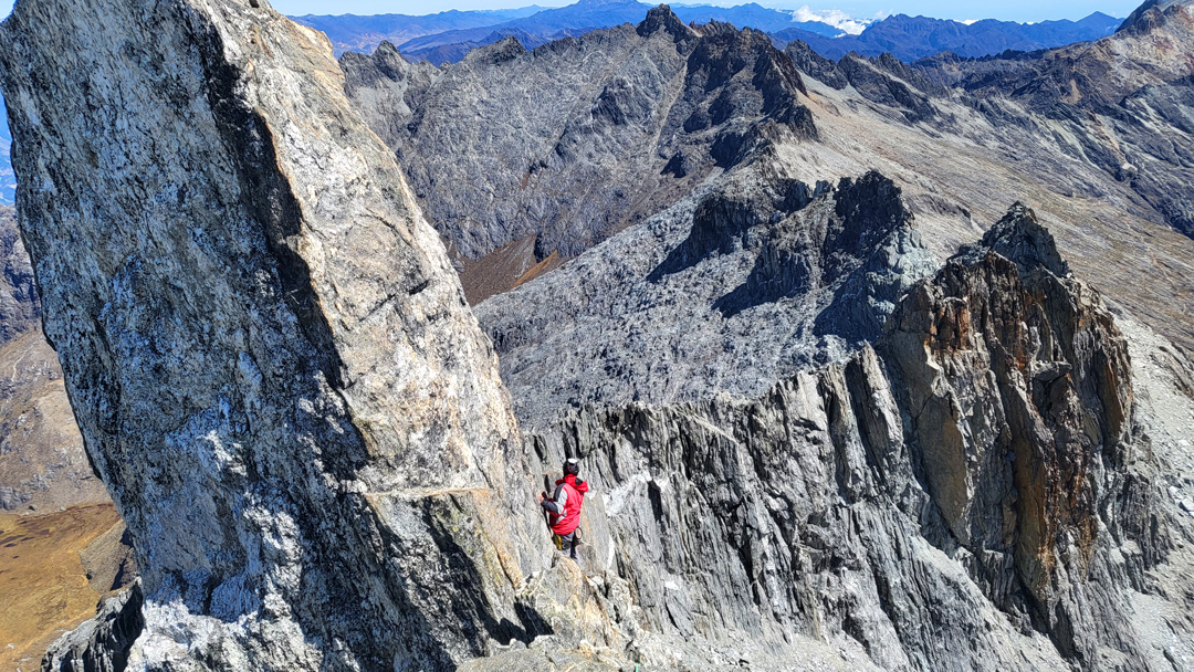
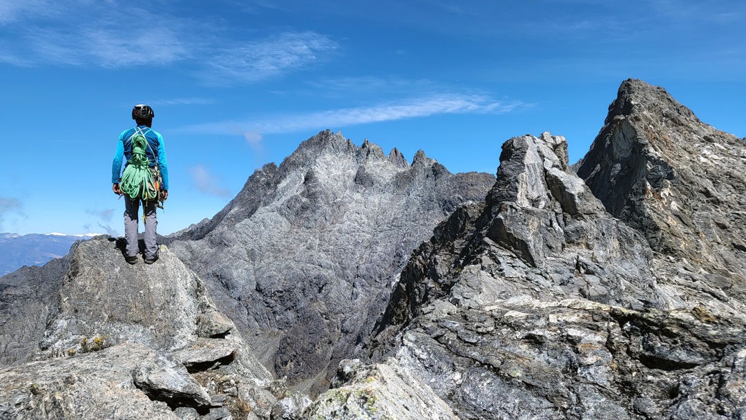
On the 11th, they traversed several summits to bivouac at the Pico Espejo cable car station. On the 12th, in windy weather, they headed east on the most interesting part of the ridge, negotiating vertical spires and exposed steps, the sight of which, Garcia said, “would either captivate or intimidate you.”
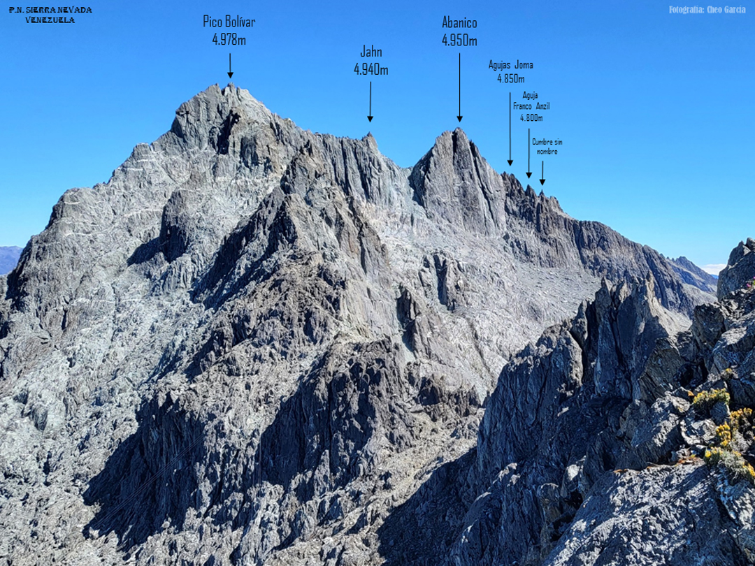
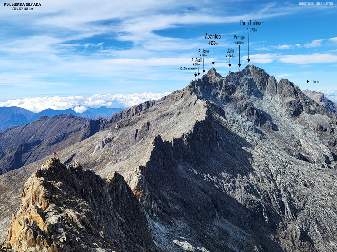
They eventually reached the west face of El Vertigo, an impressive spire shortly before Bolívar. Here, they climbed a new three-pitch line at 5.9. (The first ascent of Vertigo was made in 1962 by Kangchenjunga first ascensionist George Band from the U.K., who was based in the country while working for Shell.) The two continued over the next point, La Salle, by a modern route, Projecting the Dimension (55m, 5.10), then continued over Bolívar and Pico Jahn before descending to the Garganta Bourgoin couloir, where they left the ridge and returned to Pico Espejo for the night.
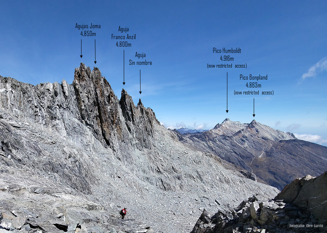
The two spent the 13th moving camp farther east. On the 14th, they climbed the steep Abanico via five pitches up to 5.9. After descending, they moved carefully through the very loose terrain of Valley of the Mica to reach Aguja Joma West, which they climbed via another new route, the three-pitch Moscovita (5.10). Continuing over three more sharp summits, they descended back to their camp.
The 15th was their final day, and they traversed the remaining ridge over La Concha, La Garza, and the Agujas Bifidas, with no rope needed—this section gave spectacular views of the ground they had covered. They named the adventure Mukumbarí Integral. Mukumbarí, a name bestowed on the range by former indigenous people, translates as “the place where the sun sleeps.”
—Lindsay Griffin, AAJ, with information from Cheo Garcia, Venezuela
Summits reached were: Pico El León (4,731m), Pico Toro Cumbre Occidental (4,735m) and Oriental, Cresta de Gallo, Dedo de Dios (4,752m), Espolón Miranda (4,761m), Pico Espejo (4,765m), Carmen (4,875m), Reina (4,890m), Vértigo (4,960m), La Salle (4,950m), Pico Bolívar (4,978m), Pico Jahn (4,940m), Albanico (4,950m), Aguja Joma West (4,850m), Aguja Joma East, Aguja Franco Anzil (4,800m), unnamed summit, La Concha II, Concha - La Garza (4,895m), and Agujas Bifidas.
Editor's Note: AAJ senior editor Lindsay Griffin climbed in this range in December 1985, completing a new route on Pico Bolívar with Jan Solov and also soloing the Toro-León traverse. His article about these adventures in 1985, a time when the high peaks held much more glacial ice, is online: Read it here.
Media Gallery