

Rivak and Oktaliok Valleys: Rubtsak Koh, East Face, and Other Ascents
Tajikistan, Pamir
 In May and June 2018, I made a 1,000km solo bicycle ride from Khorog, Tajikistan, to Osh, Kyrgyzstan, following the Gund River, traversing the Pamir Highlands via Murghab and Karakol Lake, and finally crossing the border to reach Osh. I saw huge potential for exploratory mountaineering.
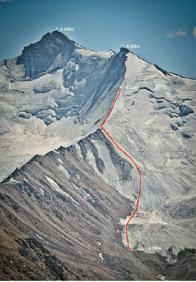
With none of my usual partners available, I set off alone in early September the same year to climb in the valleys close to Khorog. From there I traveled by road 25km to the village of Rivak, and with the help of two porters walked up the Rivak Dara (Rivak Valley) to establish base camp next to a lake at 3,870m. I remained there alone for the next 10 days. I climbed Pik 4,820m (37º38'21”N, 72º04'08”E) by its southeast ridge (1,000m, F+) and then made an attempt on Pik 5,428m (37º33'12”N, 72º06'39”E). I was stopped by a crevasse at 5,225m on the north ridge of the subsidiary summit, Pik 5,363m, the climbing to that point having been 700m, AD 55°. The reversal of my route was delicate. [The previous climbing history of these accessible peaks is not known.]
On the 19th I returned to Khorog and after a few days rest hitchhiked about 130km to the village of Jelondy (3,500m). Here, I hired a couple of porters to reach the smaller village of Oktaliok, transferred gear to donkeys, and trekked 15km up the Oktaliok Dara to install base camp at 37º39'02"N, 72º39'25”E.

Two days later I climbed a 5,227m peak at 37º37'32”N, 72º39'54”E. It took me two hours from base camp to reach the foot of the east face at 4,900m, above which introductory 35–40° slopes led to the base of a couloir splitting the face. Soft snow over loose, slabby terrain at 50° led to a steeper section at 5,050m (65° and III). Above, I self-belayed a 15m section of IV+, then continued up 50–55° snow/mixed to reach the north ridge. On the crest I had to outflank a highly decomposed rock pinnacle by a 10m diagonal rappel on the flank, followed by a section of II and 55° to regain the ridge. The final 50m along the crest had 65° ice. I reached the summit in five and a half hours from base camp and returned the same way in around three and a half hours, with four rappels and some delicate downclimbing. There was no trace of any previous ascent. After consulting local shepherds, I decided to call this unnamed peak Rubtsak Koh ("Fox Peak"), and my route Dies Que Duraran Anys ("Days That Will Last for Years," 450m, D- IV+ 65°).
– Sergi Ricart, Catalonia, Spain
Media Gallery


