Peak 6,010m, southwest face and south ridge; Sgurr Kuddu, northwest flank; Peak 5,970m, east ridge attempt
India, Himachal Pradesh

Robert Adams, Tom Adams, Steve Kennedy, and leader Andy Nisbet (all U.K.), and Bill McConachie and I (both U.S.) visited an east-west side valley of one branch of the Darcha-Mayar Valley, immediately north of Ramjak (6,318m). Our objectives were to climb unnamed peaks 6,010m (32°53'17"N, 77°08'46"E) and 5,970m, and to explore the valley for additional climbing opportunities. We would like to thank Mr. C.S. Pandey and his staff at Himalayan Run & Trek Pvt. Ltd., for providing logistical support for the expedition, and also the Mount Everest Foundation and Mountaineering Council of Scotland for financial aid.
This area was explored in 2013 by an expedition that included Robert, Andy, and Steve. They climbed Goat Peak (6,080m) and identified the peaks above as good objectives (AAJ 2014).
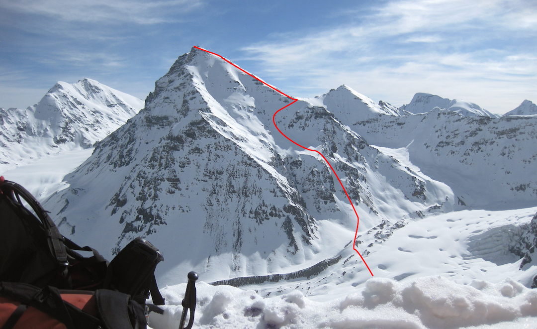
On May 31, after a previous carry of supplies, Bill, Andy, and high-altitude porter Mangal Singh approached Peak 6,010m along a rocky ridge, followed by a traverse across an easy glacier, to reach the foot of the southwest face. They climbed snow and then a couloir on the face to reach the south ridge at 5,730m, where they camped for the night.
The weather deteriorated, leading to a windy and snowy night. The following morning the weather improved and Bill climbed the ridge to the top. There were several short rocky steps, and the fresh snow was safe. Bill found bamboo wands on the summit; we had thought the peak was previously unclimbed, but it now appears to have been climbed unofficially (as far as we can tell) from the Shingo La side. The probable new route was given a grade of PD+/AD-.
During the afternoon of June 6, Steve and I, with the assistance of Lakpa Sherpa, set out to attempt an unclimbed peak of ca 5,300m on the east side of the valley we used to approach base camp. This valley lies north of Kuddu. After climbing to ca 4,700m, we established an advanced camp on snow in the lower reaches of an enclosed cirque to the northwest of the peak. Lakpa Sherpa then returned to base camp. While we were gathering water from a small waterfall adjacent to camp, a significant, slow-moving avalanche headed down the cirque toward the tent, which been set into the side of a small moraine slope. Fortunately, at the last moment, the avalanche changed direction, narrowly missing camp.
We set off at 2:30 the following morning in excellent weather, climbing on good névé via the cirque to reach a prominent col close to the base of the summit snow cone at an altitude of ca 5,170m. Thereafter, more technical mixed climbing led to the summit, with the final 130m consisting of 60–75° snow slopes and a final exposed rocky corner and snow arête. The summit comprised two rock pinnacles, the most westerly being slightly higher. Our ascent had taken about four and a half hours, and we spent an additional 45 minutes on the summit pinnacle enjoying fine views over the Darcha Valley and beyond. We named this summit Sgurr Kuddu. Sgurr means sharp-pointed peak in Gaelic, and Kuddu is the name of the area overlooked by the peak. We graded the route AD.
Several members of the team had been very excited about the prospect of climbing a large couloir on a 5,970m satellite peak northwest of Ramjak. Early in the trip, a reconnaissance showed that the face through which the couloir passed was highly avalanche-prone. The couloir itself appeared to contain unconsolidated powder and was capped by a large ice sheet and cornices. This line was discounted, but on May 31 Rob, Tom, Steve, and I attempted the east ridge, camping that night on a rock outcrop at ca 5,550m. On June 1 we continued to 5,720m, where we encountered dangerous avalanche conditions ca 250m below the summit. After returning to base camp for two nights, a second attempt was considered, but continued poor weather meant the team climbed no higher than advanced base camp.
A little later Bill and Andy made an exploratory hike to evaluate conditions on the same peak. Bill stopped at ca 5,500m (Andy a little lower) in blowing snow and poor visibility. However, there was optimism that a one-day ascent of the peak might be feasible if weather and conditions cooperated. This didn’t happen and no further attempts were made.
Paul Swienton, AAC
Media Gallery