Spur of the Moment
The Northwest Face of Aikache Chhok in Pakistan
The expedition was born in Gemma Robertson’s kitchen in Edinburgh. It was January 2025, and James Price and I had just arrived in Scotland after a very productive ten-day trip based out of James’s apartment in Flumet, France, excited for the Young Alpinist Group (YAG) winter meet.
But before then, we each had to come up with an idea for an expedition to pitch to the group—whoever’s idea got the most votes would be the expedition a YAG team would plan for later in the year. James and I both spent about 20 minutes hatching a couple of very half-hearted presentations: Mine was a very poorly researched Tajikistan trip, and James based his on a valley in Pakistan he’d never seen, although it was near Aliabad, a place where he’d spent a lot of time in recent years. Neither of us wanted our idea to be chosen, wanting no responsibility for organizing the trip. To James’s chagrin, people liked his idea, and a rough plan to head to Pakistan in the autumn was formed.
Launched in 2020, the Young Alpinist Group was the brainchild of British alpinist Tom Livingstone. The aim is to support younger alpinists from the U.K. and Ireland, but it has a much less structured approach than similar programs in other countries. We pretty much just organize trips together; everyone in the group brings different skills to the table, and we get the opportunity to learn from each other in a range of mountain environments. What you put in is what you get out of it. This expedition would mark the conclusion of our group’s three-year program.
The dates for the Karakoram trip were finalized in the middle of August, and I bought flights about three weeks before we headed out. I’d spent the summer on a commercial fishing boat out of Kodiak, Alaska, and, needing a couple of weeks to decompress, I flew out to Pakistan later than the others. My psych was low after an exhausting summer, and I’d had very little time to train. I almost bailed after James revealed that an ankle injury might not allow him to be very ambitious. But once momentum builds toward something, it’s usually easier to go with the flow, so I found myself on the plane on September 28, ready to see what the coming weeks would bring.
I landed in Islamabad at 3 a.m. on the 30th with no lift organized, nowhere to stay in the city, and only knowing I had to get a bus from the massive terminal at Pir Wadahi to Aliabad in the Hunza Valley. Wrecked from 30 hours of traveling from Salt Lake City, I sat on a bench outside the airport, trying to formulate a plan: just me, my bags, a touch of sleep-deprived delirium, and a massive crowd of people milling around. By the time the third person came out of the throng to ask if I wanted to change money or get a lift, I gave up and hopped in his car, asking him to take me to a cheap place to crash in Pir Wadahi.
Later that day, after figuring out bus times and how a squat toilet works, I managed to get some food and boarded the coach to Aliabad. The 16-hour journey was the most exhilarating of my life, the driver whipping the 50-seater bus through cities, towns, and mountain passes. Overtaking four cars on a blind corner? Not a problem, we’re the biggest thing on the road. Herd of animals in the way? Hit that horn and channel your inner Moses. Speed limits? What are those? I was laughing the whole way, loving every minute of it. Every few hours, we’d stop to get food and chai. After a lovely conversation with a family at one of these stops, a child handed me a bag of snacks for the journey, despite my protestations. It was day one, and already I couldn’t believe I had ever considered not going.
Finally reaching Aliabad, I got a lift to Hostel Nomads, where James was staying. The hostel was run by friends of his from past visits, some of whom had decided to join us at base camp and go climbing. The three women in our team—Gemma, Anna Soligo, and Sinead Thin—had already gone up to base camp with Hassan Aljabbal Ramal, one of the owners of Hostel Nomads, and I spent the rest of the day preparing to head up there with James, Adnan Khan and Najeeb Khan.
The next morning, we drove to the Baltar Valley, crammed in a beautiful 1950s jeep. Along the way, we picked up the son of Akbar, one of the herders at the pasture that would be our base camp by the junction of the Baltar and Toltar glaciers. I knew next to nothing about the area where we’d be climbing, apart from a bit of time exploring on Google Earth. James knew only a little more—both of us planned to just figure it out when we got there.
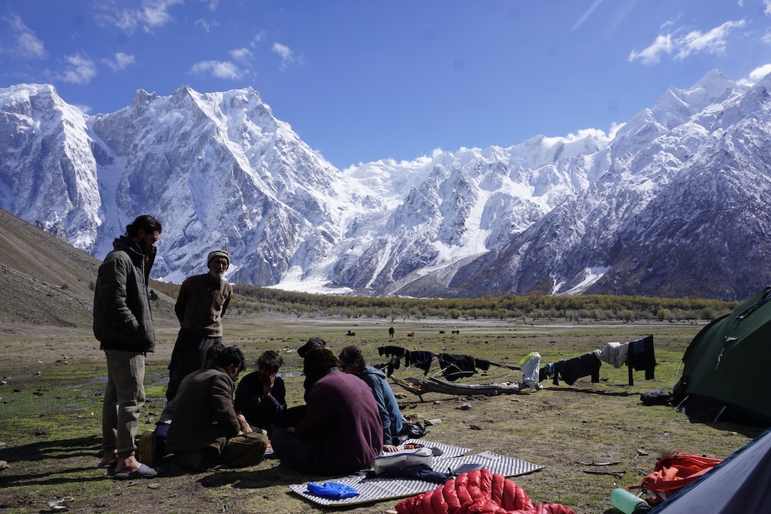
The hike to base camp would only take a day, which was a relief, as I was carrying a full haulbag loaded with gear and food. Partway up the valley, we stopped for a break at some herders’ huts, where we posed with rifles, drank salted goat milk chai, and ate go-lee, a kind of pancake boiled in goat butter. Finally, we all reunited in the pasture, ready to start looking for objectives.
Over the next ten days or so, in mostly poor weather, James and I explored the two main branches of the valley, trying to find a line that A) was inspiring and B) wouldn’t kill us. It took me a week to get over how intimidatingly big these mountains were. They made everything I’d experienced in Europe, North America, and Patagonia look like toy mountains. We saw incredible ice climbs, thousands of feet long, but when the clouds parted, we’d see they were threatened by huge seracs. We looked at the south face of Sani Pakkush, at the head of the Toltar Glacier, but knowing it had been climbed before and not knowing where that route went, we looked elsewhere. There were huge buttresses on Hachindar Chhish that would require more rock gear than we brought and an ascent in warmer months.
We acclimatized as best we could, but the weather was terrible, and we never summited anything. The highest altitude we could reach before starting up our chosen route was 4,500 meters.
That’s not to say that the time in the valley was poorly spent. Akbar had very generously allowed us to use one of his huts, a cozy, low-roofed stone structure with a fire pit in the center, a raised platform for eating and sleeping, and often some dead animal hanging off the ceiling, getting unintentionally smoked by the fire. It was a godsend to be able to cook, make chai, and just hang out when it was raining or snowing outside.
We assimilated into local life as best we could—hours were spent collecting firewood, cooking, and hanging out with the herders. James has a gift for international relations, a strong stomach for goat-related products, and a few words of Urdu—while it’s not the language of the valley, some people spoke it—therefore he spent the most time schmoozing and nonalcoholic boozing in various huts. There were memorable nights of cooking, drinking chai, playing chess, and singing and dancing. People would pop into our hut for their own version of tourism—they would sit and watch us, jump in to correct our errors as we carved spoons or cooked, and probably wonder what in God’s name we were doing there.
One day, Hassan gave us a great compliment, saying that a group of the herders had been chatting about us and exclaimed, “Those Westerners are just like us!” We couldn’t be more grateful to everyone, but especially to Akbar for his incredible hospitality, letting us join in and help around the pasture, selling us goat meat, butter, and milk, showing us tricks to make life easier up there, and encouraging us on our climbing plans. Without ever setting foot on a mountain, we could have gone home and treasured the memories from our time in that pasture for the rest of our lives.
All good things come to an end, though, and with a massive weather window approaching, we had to go climbing. James’s ankle injury had disappeared while we were up there, so he no longer had to climb with one ski boot for support. The three women had chosen an objective prior to arriving and already had made a gear stash below their mountain (see related story on p.51). Adnan and Hassan decided to head to an unclimbed pass, descend into a different valley, then loop back around to the pasture in a massive journey.
James and I had finally settled on a line up the high peak we could see right from our tent door in the pasture: a spur splitting the huge northwest face of the mountain rising more than 3,300 meters above us. We knew nothing about this mountain’s history or even its name. Only later did we learn the peak is called Aikache Chhok and is about 6,673 meters high. As we discovered after we got home, the mountain had been climbed only once, in 1983, by Italians Enrico De Luca, Gianpiero Di Federico, and Giorgio Mallucci, starting from the Shilinbar (Shittinbar) Glacier to the south, where the mountain is called Sia Chhish (see AAJ 1984).
Finally, the good weather arrived. We decided to give the mountains a day to shed excess snow, and all of us prepared to approach our objectives on the second sunny day.
James and I packed food for five days and gas for seven, with the option to ration it out if the climb took longer. Very little shepherding was getting done that day—pretty much everyone was milling around, bemused by all the equipment and psyched by our upcoming attempts. Akbar even said that if we made it, he’d throw a party in his village for us. A large group of teenagers and an imam had arrived from the village, and we spent a while talking to the imam, who decreed that although a big, steep glacier to the right of our planned starting gully was very dangerous, “for you, tomorrow, it will be safe.” At the risk of being blasphemous, we decided to stick with our original plan.
The commotion all got a bit much, and James and I slipped into our hut 30 minutes before leaving to clear our heads. I needed time and space to justify this climb to myself. Akbar came in, and, clocking the mood, silently started making chai. A couple of our other herder friends entered as well. We sat there in the dark, James listening to music, me staring at the wall, and Akbar gently singing. With that send-off, I felt like it would be a waste of good karma not to do the climb.
We left at 2:30 in the afternoon on October 12, following hunting paths to the glacier, then up to the base of the mountain at around 3,700 meters. We continued up a couple of hundred meters to reach a safe spot to camp, off to one side of the starting gully, and stopped there.
Inconveniently, both of our packs broke during this approach—the shoulder straps on mine, and the waist belt literally falling off James’s pack. I cooked that night while James repaired both packs with the sutures we’d brought. Ideally, no one would need stitches over the next while.
Day 1: We settled into our rhythm for the route: Wake around 4:15 a.m., make breakfast and coffee while listening to our morning ration of five songs, and leave by the time it was light. We were ecstatic to find our gully filled with ice, not just powder snow over bare rock. We soloed up the gully, then up a smaller gully branching left, to get to the start of the first mixed pitches.
Putting on the rope, we climbed six tenuous pitches, linking up small snowfields, inching toward the ridgeline. The most memorable pitch involved traversing over to a side gully/chimney thing, lowering off a cam to get into it, then squeezing up, gently tapping into bits of ice at the back. James made a smooth little tensioned jump into the gully when seconding.
We reached the rock buttress guarding the ridge just as it started to get dark and dug out an amazing bivy spot at about 4,500 meters, happy with our progress and thinking that five days on the route would be totally feasible. We flashed our headlamps at the pasture at 7 p.m., just as Akbar had asked us to do each night. A constellation of lights reassuringly flashed back at us.
Day 2: It didn’t take long to knock the optimism right out of us. A couple of hours after starting, only half a rope length up, I finally went off belay and started to haul my pack. The pitch had involved difficult mixed climbing (as far as you can judge these things in the mountains) and a fair bit of aid, pounding in pitons and ice axes to aid off. It finished with excavating endless powder to inch my way up to the belay stance.
James set off on the next pitch, aiding an overhanging, cracked wall that got progressively looser. After another couple of hours, he built a five- or six-piece belay, and I made my way up in any way possible. (We didn’t bring jumars.) I needed a few minutes at the belay to get my biceps working again, then headed up the final pitch to the ridge, with some deep powder excavation—thanks, Scotland!
We moved up the ridge a bit and stopped at a spot on the southwest side, soaking up the first sun we’d seen in a few days. We’d only gained a couple of hundred meters all day, but with a bit of rationing, a six-day climb still seemed totally feasible.
Day 3: We started this day by skirting a large rock buttress we just couldn’t climb without rock shoes and more gear—we had to head up a very steep, cracked-up glacier on the right of the ridge, aiming to get off it as fast as possible. The terrain funneled us into a choke point between the glacier and the rock buttress, and it seemed like our only option was to go up an ice chimney formed between the two. I didn’t like it, James didn’t like it, and looking back, trying to go up it was our only real mistake of the route.
I took the lead, with the aim of motoring through it quickly, but once inside the chimney and over a bulge, I looked up and saw the glacier had formed a roof composed of ice blocks all just pushed together. Simultaneously, I heard the glacier groan and instantly wanted to get right the fuck out of there. I made a V-thread, rappelled off, and asked James to find a way through the glacial maze to the right—the chimney was a no-go. He agreed, having already fully disconnected himself from the rope while I was up there, just in case. Sure enough, 20 minutes later, as we were inching up the glacier, the whole roof collapsed.
Soon we managed to get off the glacier and onto snow ramps on the side of the ridge. More pitches of fun mixed finally brought us back to the crest, then to the base of what we’d dubbed the “second rock step.” This was one of the major question marks of the route—climbing the rock looked too tricky, but while scoping this section from the valley, we had spied some ice on the left side that might let us through. We were at 5,500 meters now, and from the bivy, we got to play the Morse code game again with the pasture, having been out of view of it the night before.
Day 4: The wheels started coming off the wagon. We abbed down to the ice slopes on the north-facing side of the rock step, then did two long, traversing pitches on rock-solid ice that required a good hammering to get placements. We were carrying eight screws (plus a double rack of cams, a set of nuts, a couple of beaks, and a few pitons), and our strategy was to use six screws per pitch as protection, then place one to hang off at the end, and use the final long screw to make a V-thread for the belay. Six screws to protect 60-meter traversing pitches felt unsettling.
I spied a possible way to get up to an easier section of the ridgeline and cut out a few of the traversing pitches. After ditching my pack to haul later, I quickly climbed straight up to some very snowy and steep mixed climbing. The higher I got, the looser the blocky rock became, but I finally made a belay I was kind of happy with. James tried to continue but was stopped by very loose rock blocks right above the belay.
At this point, having barely made any progress and with darkness approaching in a couple of hours, we decided to retreat to our previous bivy. It wasn’t easy, though—we had to repeat the traverse pitches, then climb a difficult pitch back up our abseil route. That day, we had climbed two of the most taxing pitches of the entire route, and they didn’t even contribute to the ascent.
The mood back at the bivy was somber—I can’t speak for James, but I was really worried we might not find a way through and we’d have to bail once again across those spooky icefield traverses and back up our abseil line. We decided to give it one more go, with a better strategy. As the more experienced ice climber, I’d get a light leader pack and a mandate to get through as quickly as possible—there would be no bivy site until we were past the second rock step. Our originally planned five days was starting to look like a very optimistic seven days, and quite probably eight. The gas canisters were lasting longer than we’d expected, but we would have to ration food further.
For a little pick-me-up, we decided to eat the custard packet we’d carried. Unfortunately, the Pakistani definition of custard doesn’t seem to match ours, and our Jetboil ended up caked with a plastic-like orange substance that vaguely smelt of mango but tasted like it would glue your intestines shut. Despite our hunger, we threw it away. Flashes of light from the pasture made us feel better—Akbar was watching over us.
Day 5: A mindless, painful blur. We made good progress through the initial traverse pitches, then took a different line from the previous day to try to avoid the dangerous rock where we had dead-ended. In between the slabby sections, there was some proper difficult climbing, involving gentle tapping to move through disconnected ice over rock bulges, some mixed terrain, and vertical ice.
After five pitches, my body was starting to give out from the constant hammering, leading to fatigue errors such as picks not buried well or both feet blowing at the same time. I began to genuinely worry about getting seriously injured—one screw every ten meters didn’t do much to calm the mind.
Darkness fell as I finished the second-to-last pitch. The final lead went up the right edge of a serac that butts up to the top of the rock step, and was composed of ice for the first half, then snow rearing up to the ridgeline. At the end of the ice, I took a few minutes to compose myself, then launched up the ever-steepening snow, alternating between shit sugar and decent névé. I turned my mind off and just made sure to kick each foot as deep as I could, punching my fists through the snow whenever the névé disappeared. Close to the top, I found a small slot with some ice in the back, providing much-needed mental comfort once two screws went into it.
When I got back on the ridge crest, I uttered a genuine scream of pure relief, took a few steps forward, and stumbled into a crevasse beside the serac. I just lay down and put James on belay. Casualties of the day included a chipped pick, two partially broken ice screws, and the V-threader. We had gained 250 meters of altitude in two days, every meter hard-earned. We did see flashes of light from the pasture, though.
Day 6: We ignored our 4:15 wake-up time and slept until it was light outside. We hadn’t seen the sun during our rock step shenanigans and now gratefully absorbed all the rays we could. I was mentally done in from the previous day, so James took the lead. Hoping for a snow ridge leading upward, we were dismayed to see black ice, and James probably pushed the limits of human calf endurance that day.
To manage it, we started to do what we dubbed the “Karakoram flop.” To execute a good flop, you climb as far as you possibly can (ideally simul-climbing) until your calves give out. Then you drive in your axe, clip in, hang from it, and allow every muscle in your body to relax. Don’t fight anything—if your pack starts pulling you upside down, just go with it. After about a minute, maybe start to think about putting in a screw and continuing.
Our late start punished us, and once again we reached our bivy spot after dark, situated in a crevasse at about 6,200 meters. We were at least another day from the summit, and our expected time on the route had extended to nine days, reducing rations again and eliminating any chance of me making my scheduled flight out of Pakistan. We were out of view of the pasture that night, and the bivy felt lonelier for it.
Day 7: In the morning, I had to put on my big-boy shoes again. I’d lead the pitches up to the summit ridge, then James would take us to the top. Both of us were thoroughly sick of black ice, but there was more to come, plus an actual ice overhang to get established on the final stretch leading to the ridge—the mountain wasn’t giving anything away.
At my final belay below the ridge, the sun finally poked its head out, and despite not being religious, I offered up a genuine prayer, thanking God for the sun—then, to be safe, I offered up a prayer to Allah as well, then to Buddha, as I’d heard this region had maybe been Buddhist at some point. Whoever’s up there didn’t appreciate it, as a storm cloud then settled around the top of the mountain.
James, a workhorse, started plowing toward the top. We got to a point where, according to the map, the summit should be only 70 meters away, but we couldn’t see anything in the storm. I took over for the final bit of trail-breaking, and 30 minutes later, I was way past the summit point on the map and still going uphill. Through the fog emerged a large cornice, probably requiring two more pitches to surmount. In the blowing snow, we couldn’t tell if we were on a knife-edge ridge or a wide plateau, so we dug a deep pit, got out the tent, and threw everything and ourselves inside.
That bivy was awful—our sleeping bags had gone flaccid, and we were suffering from the altitude and general exhaustion. For the first time, James wasn’t efficiently organizing the bivy, and I took the lead on preparing water and making dinner. We shivered the night away, as dark thoughts about a possible tenth day on the mountain invaded our minds.
Day 8: The clouds cleared overnight. Breakfast was efficient, as at this point our rations were limited to a single Clif Bar split between us. We had two Jetboils of coffee, though. (We weren’t in any danger of running out of coffee or salt—very French of James.) Just below the top, James measured the elevation at 6,673 meters with an inReach. We individually tagged the summit, with a belay, then thoughts turned straight to how to get off.
We had a vague idea of where we might descend off the west and northwest sides of the mountain—descending our ascent route had never been an option. We picked a west-facing gully and started down, with some rock abseils and then endless V-threads, with glacier crossings in between. James took the lead on the glacier travel, being the best person I know at safely navigating glaciers. For the first time in days, we were making good progress, and we reached a good bivy spot at 5,000 meters just as it got dark.
We had some instant mashed potatoes and divvied up the rest of the food to save for our final day on the mountain. There was a direct line of sight to the pasture, and after two nights with no connection, our lights shone brightly back and forth. No matter how irrational, it felt like Akbar would figure out how to rescue us if anything went wrong.
Day 9: I couldn’t get out of my sleeping bag. This time it was James’s turn to pull it together and make sure we had our coffee, a handful of nuts, and a few slices of dried apple while I shivered in my bag.
After packing up, we made our way down to the north, aiming to reach the ridge between two glaciers that dropped right to the base of the mountain. Getting off from this point was the last big question mark of the route, and unlike the rest of the descent, we’d been able to study the problem thoroughly from the pasture. Unfortunately, we were never able to figure out a good solution. The glacier on the right (looking up) was insanely cracked, and the towering blocks of ice were constantly collapsing. The one on the left was less broken but was threatened by huge seracs that shed ice every day or two. Neither option called to us, so we started abseiling down the rock buttress between them.
A few hours later, we reached the convergence point between the glaciers, a couple of hundred meters from the foot of the mountain. With no other option, we decided to cross the serac-threatened left glacier.
First, though, we came up with a strategy to get across as fast as possible. I abbed first into the little valley between the two glaciers, tied into one end of the rope, and as soon as James hit the ground with me, I started climbing up the side wall of the glacier to get on top of it. (I couldn’t believe we still had to do technical climbing right at the end—this mountain really never let up.) Once on the glacier, we abbed over a step, ran to the other side, and abbed to the base, leaving screws behind for speed. We walked a couple of hundred meters away around a rock buttress, and suddenly we were done!
Unused to being safe, we walked back to the pasture, where we were greeted by a chanting mob dancing, placing flower garlands around our necks, and firing rifles into the air. Najeeb, who’d had to leave the pasture for a family emergency, had even walked back up to base camp the day we got back; it was touching to see him in the welcome committee.
That evening, I ate until my stomach hurt. I’d gone from 180 pounds to 158 pounds over the past month, and James had gotten frostbite, but only on the nubs of toes he’d already lost, during a psychotic 17-day solo outing on the Batura Wall in 2022. Overall toe count remained the same. The next day, we got to Hostel Nomads late in the night, then gathered around a fire to listen to songs from local musicians, drink Hunza water (a local poitín), and appreciate life.
I had avoided expeditions to Asia, as I thought they would be too expensive and logistically difficult. I couldn’t have been more wrong—it was far cheaper than going somewhere like Alaska, and the logistics couldn’t have been easier. Just turn up, walk in, climb, and walk out. It’s how we climb in most other mountain ranges of the world, and I wouldn’t have wanted to do it any differently.
SUMMARY: First ascent of the northwest face of Aikache Chhok (6,673m GPS), by George Ponsonby (Ireland) and James Price (U.K.). The round trip from base camp was October 12–21, 2025, and the two reached the summit on October 20. The descent was to the west, northwest, and north, returning very near the start of the climb. The route is called Secrets, Shepherds, Sex, and Serendipity (“after a silly Bollywood-style play we came up with at base camp”); the climb gained about 3,000 meters, and the grade was about AI5 M7 A2+.
ABOUT THE AUTHOR: Born in 1996, George Ponsonby grew up in Ireland but is currently based in Salt Lake City, trying to juggle climbing with being an engineer in the land of ten-day annual vacations.
This expedition received funding from the Alpine Club, Mount Everest Foundation, and Scottish Mountaineering Club. The author adds: “James Price deserves massive credit for shortcutting our Pakistan learning curve, and Hassan, Adnan, and Najeeb provided invaluable help and showed us around Hunza after the climb—I hope to return the favor in the States one day. Most of all, we need to thank the herders of the Baltar Valley, especially Babur, one of the kindest, friendliest people I’ve met, and Akbar, for his hospitality and confidence in us. I hope the pasture crew enjoyed having us as visitors as much as we enjoyed being there.”
Media Gallery