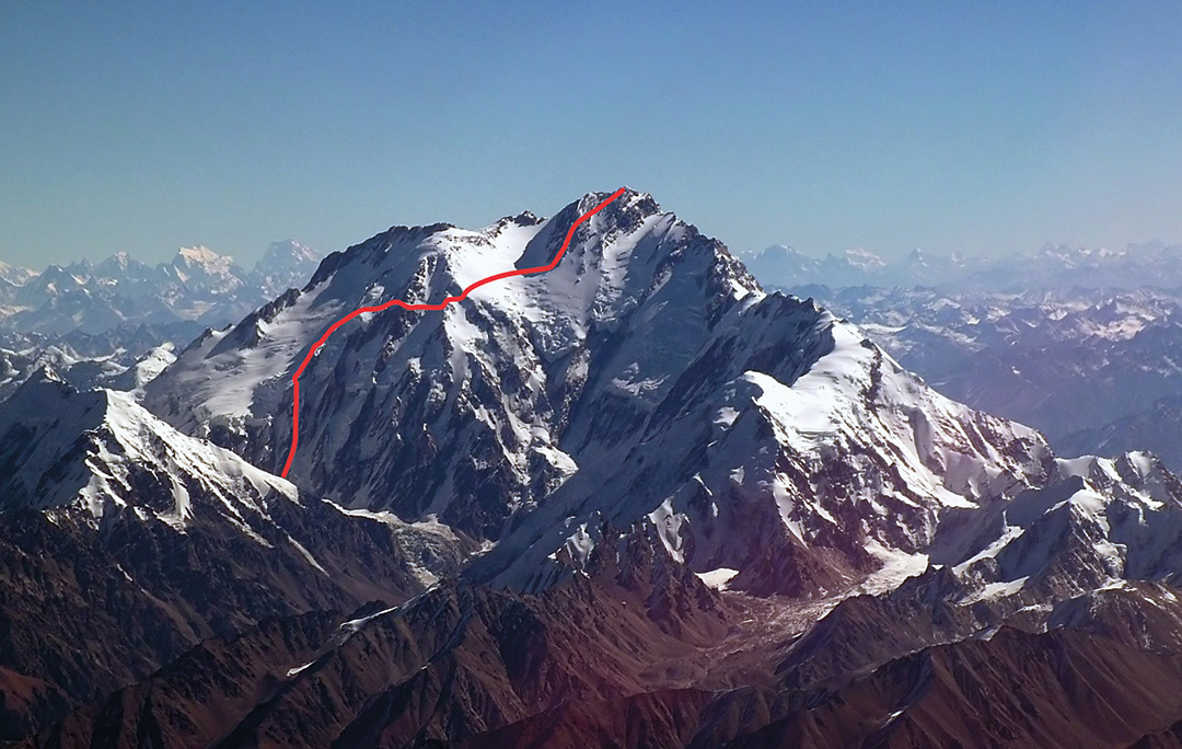
Nanga Parbat, Northwest Face, Nezabudka
Pakistan, Himalaya
In July, Denis Urubko (Russia) and I completed a new line on the Diamir Face of Nanga Parbat (8,125m), climbing in alpine style, with no fixed ropes during the ascent and no assistance from other climbers. We reached the summit on July 10, our fifth day out from base camp. [This was the first new route to an 8,000-meter summit climbed in alpine style by a woman. See the editor’s note below for details on the line’s relationship to previous routes on this aspect of Nanga Parbat.]
We began acclimatization at home in Europe, then by climbing around Skardu in Pakistan for almost two weeks, reaching two summits over 5,000 meters. Once in Nanga Parbat base camp, we climbed to 6,200 meters on Ganalo Peak, spending several nights at around 5,500 meters, then climbed up to 7,000 meters on the Kinshofer Route, sleeping twice at 6,800 meters.
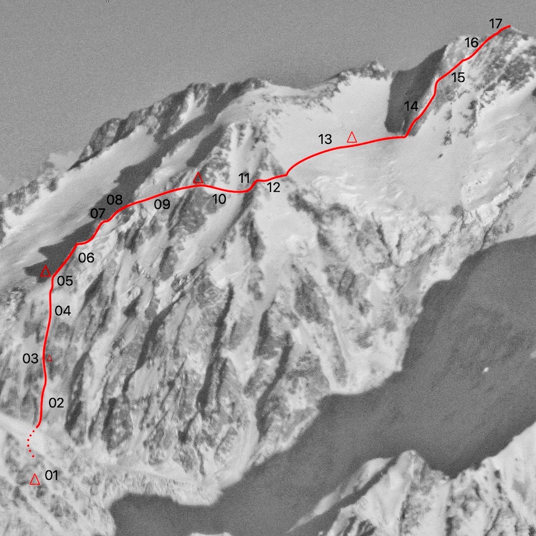
On July 5, we left base camp (4,150m) at 10 a.m. and passed Camp 1 on the Kinshofer Route at 12:30 p.m. We continued east on the Diama Glacier to around 5,280 meters, where we stopped to camp on the left (south) side of the glacier at 4 p.m.
We started the next day at 2 a.m., crossing the glacier. At 3 a.m., we crossed the bergschrund and began climbing our chosen line, moving together for about 200 meters. At 5,550 meters, a 60° hard ice slope began. We climbed 14 pitches until the sun reached us and rocks began falling down the couloir, with some very large blocks. We stopped by the left wall of the couloir and carved a small ledge at around 5,850 meters, where we sat for seven hours until the rockfall ended.
At 7 p.m., we started up again and climbed 19 more pitches, including one section of 80° ice and two 10-meter stretches of rock. (We belayed using a 43m 7mm rope and a 40m 6mm rope.) After climbing all night, we reached easier snow and continued up, moving together, until we could find a bivouac site. At 11 a.m. on July 7, we placed our tent inside a crevasse at 6,420 meters. A storm arrived with very strong wind and snowfall, and we rested inside the tent for the rest of the day. Afternoon and evening storms produced 15 to 20 centimeters of snow each day during our ascent.
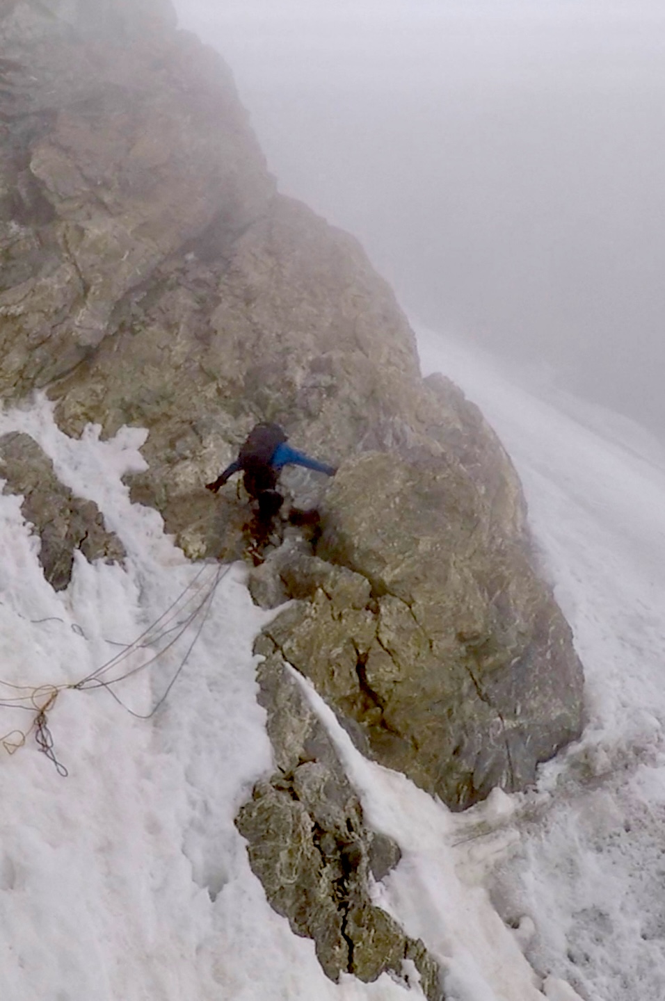
We started again at 2 a.m., continuing up the snow slope, then climbing about 150 meters of mixed terrain on a rocky triangle (50° to 60°, M4), the first part of this in the dark. We belayed four pitches. The ridge above leading to Kölblinger Col was easy, moving together on rock and snow.

On the next bastion, at 6,750 meters, we began on a hard snow slab on the right side, climbing two pitches with ice screws, then turned left onto 50°–60° rock, where we climbed four pitches (M4). We avoided a tower at 6,850 meters by passing it on the right side, moving together, then reached a broad terrace and continued easily through 15 to 20 centimeters of new snow. At 3 p.m. we reached a safe rock ledge as a storm started and set up the tent. The elevation was a little over 7,000 meters.
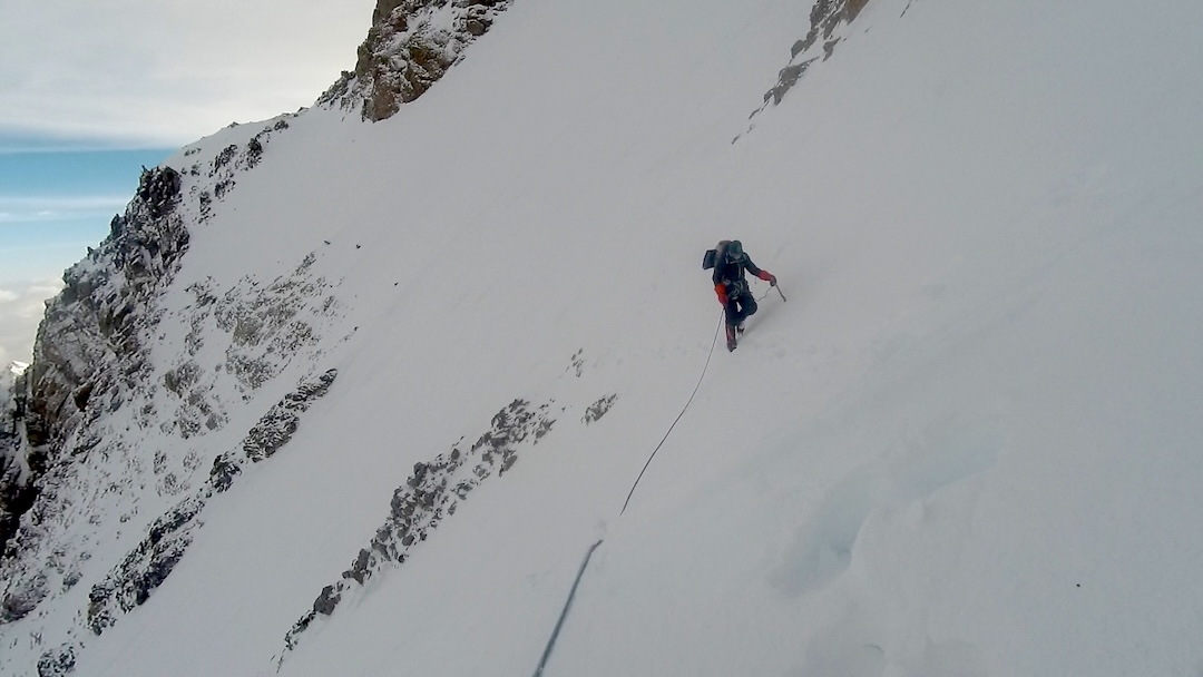
On July 9, our fourth day, there were no technical difficulties until 7,025 meters, where we climbed a pitch between smooth 45° rock slabs. We then climbed two mixed pitches (M4) to avoid an avalanche-prone traverse. Following an easy snow traverse, we reached the Kinshofer Route and continued into the Bazhin Basin at 7,100 meters. Through deep snow—sometimes up to a meter deep—we broke trail up to 7,300 meters, where we placed our tent.
Starting again at 2 a.m. on July 10, we continued through deep snow, passing crevasses, to reach the lowest rocks on the summit pyramid at about 7,350 meters. On the left side, we climbed a narrow 40°–50° gully, belaying four pitches where the snow was firm. Above 7,750 meters, we moved right over rocky slabs and snow terraces, climbing together with natural protection, to the summit ridge. We reached the summit at 11:30 a.m., then descended to our tent following the normal route.
We started down again at 3 a.m. Because of high avalanche and crevasse risk on the plateau, we stayed above the classic Kinshofer line until the lower corner of the plateau, at 7,100 meters, where we continued down along the fixed ropes, sometimes using our own ropes and ice screws because the existing lines were in poor condition. After 12 hours of descent, we returned to base camp.
—Maria Jose Cardell Fernandez, Spain
Editor’s Note: The new route was named Nezabudka, the Russian word for forget-me-not, the small blue flower that covers the meadows at the foot of the mountain. The route gained 3,975 meters above base camp and about 2,825 meters from the foot of the north face. In a broad sense, the 2025 route paralleled the Austro-Canadian Northwest Buttress (AAJ 2010), but it was mostly independent, starting up a separate couloir system to the right of the 2009 route, intersecting it at points between 6,600 and 6,800 meters, then staying below the 2009 line on the long traverse to the Bazhin Basin. On the summit pyramid, the climbers generally followed the 1978 variation to the Kinshofer Route pioneered by Austrians Wilhelm Bauer, Reinhard Streif, and Rudolf Wurzer.
Media Gallery