Manaslu, South-Southwest Face, New Route
Nepal, Manaslu Himal
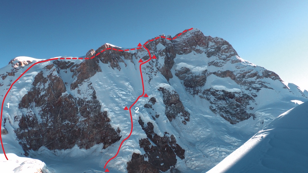
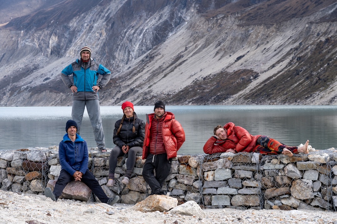
In 1972, a Tyrolean expedition led by Wolfgang Nairz completed the third ascent of Manaslu (8,163m) by a new route on the south-southwest face. Reinhold Messner summited alone in worsening weather, and Franz Jäger, who turned back before the summit, never returned to high camp. This route has been repeated multiple times, but before 2025, no other lines were established on this face. [The broad south side of Manaslu is bordered by the Tyrolean route on the left and the south ridge on the right; the south ridge was attempted multiple times before the first ascent by a Polish team in 1984, with Aleksander Lwow and Krzysztof Wielicki making the summit.] Our team—Natalia Belyankina, Kirill Eizeman, Sergei Kondrashkin, Vitaly Shipilov, and I—planned a new route near the center of the face.
In 2024, Eizeman, Kondrashkin, Shipilov, and I had tried the Yefimov Route on the east ridge of Cho Oyu without supplemental oxygen or Sherpa support. We failed to reach the summit but gained critical experience for sustained climbing above 7,000 meters.
We acclimatized in 2025 on the normal route of Manaslu, on the northeast side of the mountain. To reduce costs, we based ourselves in Samagaon, the village a kilometer below the usual base camp; the lower altitude allowed better recovery between rotations. We summited Manaslu by the normal route, without oxygen, spending two nights at 7,450 meters. From high on the mountain, we observed the glacier basin between Manaslu and neighboring Thulagi (7,059m).
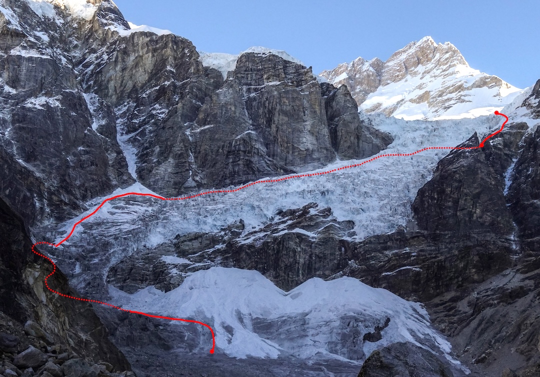
We then relocated to the southwest side of Manaslu and set our base camp by the lake called Duna Tal (various spellings, 4,100m) on October 9. We flew a drone for reconnaissance, but it crashed early on, leaving us to rely on old-school route-finding. We left base camp on October 12 with heavy packs (32 to 35 kilograms each), including food for 12 days.
After two days of reconnaissance, on the 14th we entered the Thulagi Glacier icefall at 4 a.m. and started simul-climbing through the left section. [Overcoming or bypassing the chaotic Thulagi icefall is considered the crux of the 1972 route. The Tyrolean team passed it by a rock buttress on the right (VI). Some later ascents have climbed through the icefall on the left side. The Russian team started up the left variant, then traversed to the right side of the icefall and gained the glacier by a rock step.] The main objective hazards were serac fall from the center of the lower icefall and rockfall from a couloir on the slopes of Thulagi. That evening, we traversed to the right side of the icefall and bivouacked near some rocks at 5,400 meters.
On October 15, we climbed an ice step and a short rock section, then continued over snow-covered slabs where fragments of old ropes were still visible, and finally reached the upper Thulagi Glacier.
The next morning, as we crossed the glacier, we studied the southwest face and discussed possible lines. We chose a logical route on the left side of the steepest part of the face, more than 500 meters right of the Tyrolean route. Based on what we could see, the main uncertainties appeared to be the passage through a serac zone low on the face and the steep upper section, where no potential bivouac sites could be seen.
The snow conditions were good, as the last snowfall had been a week earlier, and bare ice was exposed on most slopes. In another season or under different conditions, the route could be highly avalanche prone. In the evening of October 16, we set Camp 1 below the face at 6,300 meters.
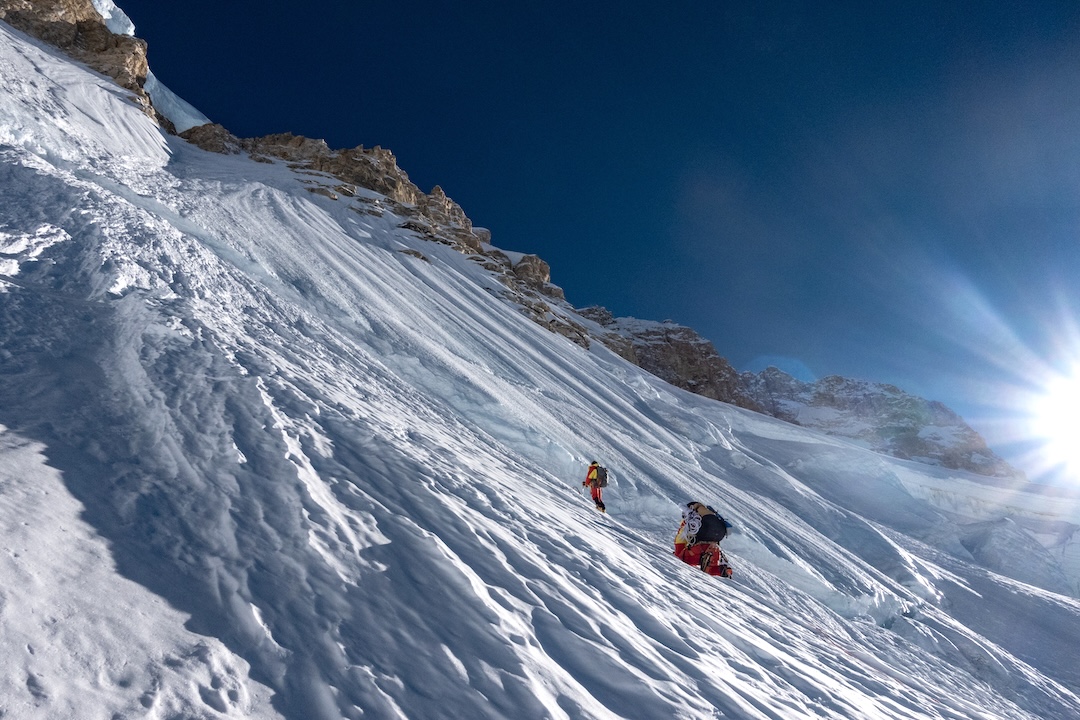
We started up the new route on October 17. The lower part consisted of 30°–50° snow with short sections of ice. We bivouacked on a broad bulge at 6,900 meters below a serac band.
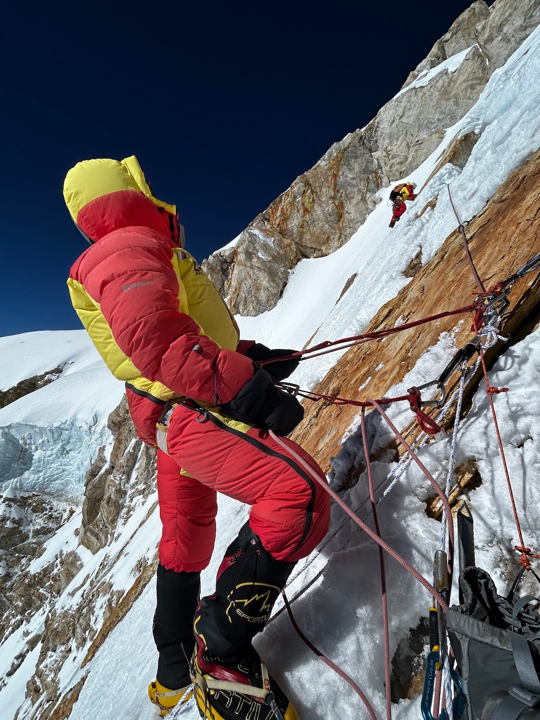
On October 18 we climbed through the seracs, reaching the bergschrund below the steeper upper face at 10 a.m. Above, the slope continued at about 60° with no visible places to stop for a bivouac. With that in mind, two of us climbed ahead and used all five of our ropes to fix pitches, while the others dug out a bivy site beside the bergschrund and recharged their energy for the next day’s push.
We woke at midnight on the 19th and at 3 a.m. began climbing along the fixed ropes, removing the ropes to continue up the steep slope. The leader moved as fast as the altitude and heavy pack allowed. Finding protection was extremely difficult—we had every kind of snow and ice gear, but nothing worked well, and progress was slow. Around midday, the wind strengthened across the plateau above, sending down small powder avalanches.
We had planned to climb to the ridge directly through a short rock band, but constant spindrift made it appear unsafe. We chose a second option, traversing right into a snow couloir that seemed longer but safer, hoping to find a relatively level spot for a bivouac. But there was none.
By nightfall we were exhausted and began cutting a ledge directly on the 60° slope at 7,400 meters. The ledge was about a meter deep and four meters wide. We stretched the tent fly overhead for wind protection, sat on pads, and covered ourselves with a synthetic blanket. As we were unable to use our sleeping bags—only down suits—it was cold for the climbers on the edges and barely tolerable in the center. We weren’t able to melt snow for water that night, and the bivouac drained our strength and slowed us the next day.
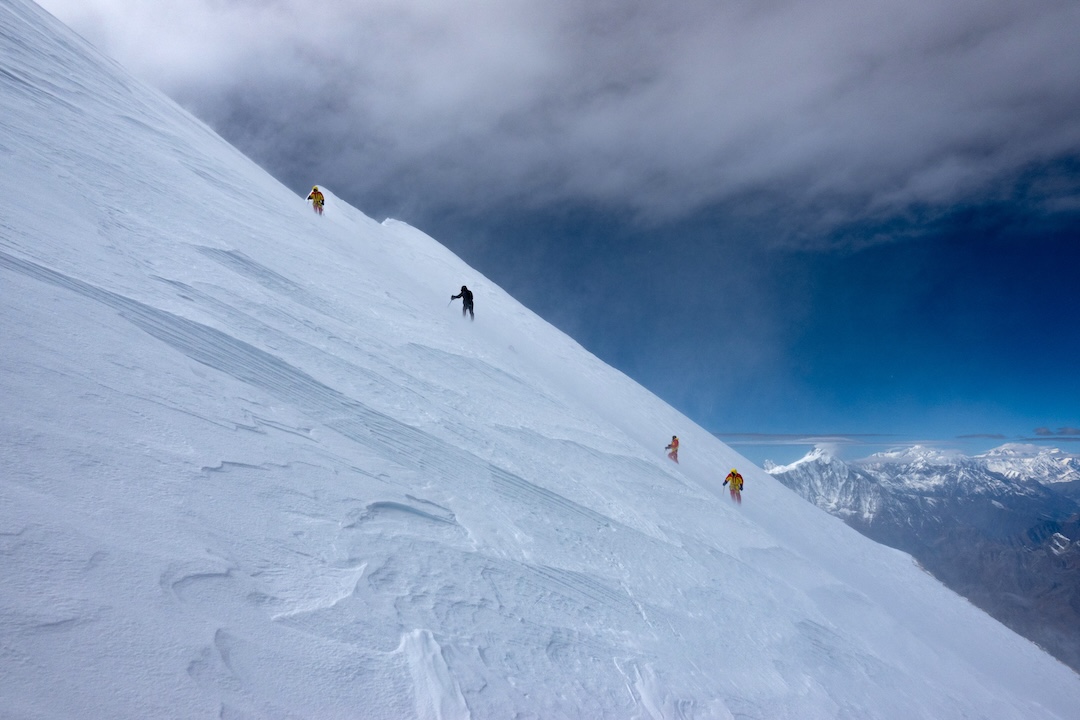
We started moving only after sunrise on October 20, beginning the day by melting a small amount of snow for water. The first lead began around 11:30 a.m. Protection remained difficult to arrange in a thin layer of firn, then 15 to 20 centimeters of powder snow, and below that porous ice where screws barely held. Higher up, the terrain turned mixed and steeper, but rock placements finally allowed secure belays.
We climbed only four pitches that day. Ahead the slope seemed to ease, and there was finally enough snow to carve a bivy site for our large tent, but the angle was still steep.
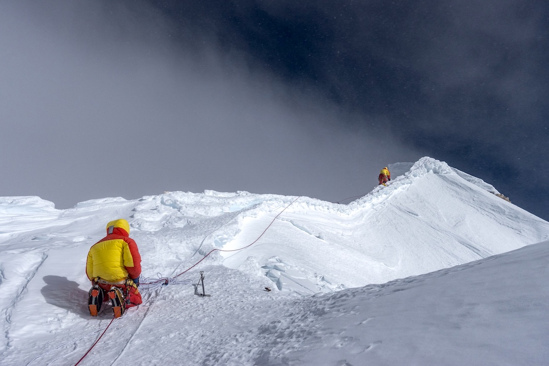
On the 21st, the slope, instead of easing, grew steeper and the terrain more complex. A narrow rocky ridge led into steeper mixed ground. Nonetheless, by evening we reached the plateau at 7,730 meters, west-northwest of the summit, where our route joined the 1972 line. The wind strengthened as we set the tent on a flat spot.
On October 22, the forecast predicted winds of 55 kph and temperatures around -25°C. We took two ropes and minimal gear and started for the summit in poor visibility. The wind came from the southwest. Along the sharp ridge between the foresummit and the main top, the gusts were violent.
In late afternoon, we summited in pairs—Sergei and I at 3:50 p.m., followed by Kirill and Natalia, then Vitaly. We took a few quick photos and immediately started down, spending no more than 20 seconds on top. At one point a dark front swept in and the wind hit so hard we dropped to the ground, barely able to breathe. Fortunately, Sergei had already crossed the sharp ridge back to the foresummit and the others had not yet begun to move. We neared the tent after dark and had to search for it. Most of our devices were dead, leaving only an inReach for tracking.
Late on the 23rd, we started down by the 1972 route, first descending the slopes to the west-northwest, then down the steep glacial slopes to the southwest, rappelling and downclimbing, and ultimately reached the Thulagi Glacier on October 25, nearly out of food. We then crossed the glacier and descended through the icefall back to base camp. The full descent from high camp took five days, from October 23 to 27.
Our climb was completed in alpine style, without fixed camps, supplemental oxygen, or Sherpa support. From base camp to base camp, it took 16 days. We spent six nights above 7,000 meters. The vertical gain on the new route was about 1,400 meters. Most of the route was a firn and snow slope of 45° to 60° with very bad protection; the upper route had short sections of steep mixed climbing (M4).
— Andrey Vasilyev, Russia
Media Gallery