Charmed in Mugu: Kaqur Kangri's Southwest Arête
Nepal, Western Nepal, Mugu District
I was not expecting so much delight.
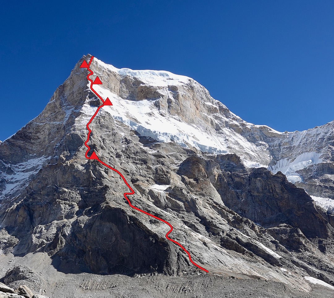
Ryan Griffiths, Matt Zia, and I had come to the sparsely populated Mugu District in western Nepal to attempt a tall line on the south side of Kaqur Kangri (a.k.a. Kanti Himal, 6,859m), a majestic butte of a peak on the border with Tibet. We had pictures of half the mountain and an old, almost Victorian description of the south face from The Himalayan Journal. We would take our best shot at the obvious sharp prow in the photos—the unclimbed southwest arête—but we had a more or less cheerful willingness to fail. We figured we’d get up something or another, and, if nothing else, roustabout for a month in a remote valley that, as far as we knew, hadn’t seen climbers in a quarter century.
Matt and I had met in Patagonia in 2016 and climbed in the Chaltén massif, where we discovered a good chemistry. We have since shared the rope in Montana—my home state and where Matt and Ryan both live now—and in India. They are professional guides: ice in winter, alpine rock in the summer, and Ryan in Alaska in the spring. I’m based in Seattle, work in public policy in the energy sector, and climb when I can.
I approached Matt in March 2024 about returning to the Himalaya, my fifth expedition to the region, and he suggested that Ryan round out our ideal team size. We roped up once as a group, when Matt and Ryan visited me in Squamish. There, we uncovered a shared mid-pitch propensity for breaking into a contagious twang and delivering laconic country wisdom: “You know what they say,” delivered in a deadpan drawl, followed by a pause, “you can’t pickle a possum without gettin’ vinegar on your britches.”
Kaqur Kangri was our preferred kind of objective: high enough to require extra effort, low enough to still let you reliably pull hard, and relatively off the radar. The southwest arête appeared to stick to the best rock on the south side and mostly avoid the impact zone of two shelves of active seracs that loom over the rest of the south face—one about halfway up, the other just below the summit. It’s still hard for me to believe there is a mile-thick hunk of stone that good just sitting out there minding itself, evading the paparazzi.
The mountain is in the far north tip of Shey Phoksundo National Park, which spans a wide range of ecosystems, including the rain shadow north of the Kanjiroba massif. That area includes much of the Kanti Himal mountains, of which Kaqur Kangri is the most prominent peak. Kaqur was first climbed by a Japanese team from the alpine club of Doshisha University in Kyoto, led by Toyoji Wada, in September 2002. The eight-member team (including three Sherpas) approached from Tibet and summited by the east ridge after fixing lines.
Japanese expeditions from the Osaka Alpine Club had reconnoitered the Nepalese side several years earlier. Sadao Yoshinaga, the leader, described their first view of Kaqur Kangri in 1997, from a border peak to the north, in the 2001 Himalayan Journal (paraphrased slightly): “[A] tall gigantic peak dominating others came into their sight.…The shape of the peak was just like a big vaulting box piled up to a 1,000m height with snow and ice.”
In 1998, a team of four Japanese and 20 porters hacked through thick shrubbery to reach the south side: “The awful south face of 1,800m high was standing in front of them,” the same article reported. “The south face itself is composed of [a] lower half of rock precipices and upper half of overwhelming hanging glaciers with numerous huge ice cliffs, defending against the raiders into the face.... It seemed to be impossible to find a feasible route to the summit. They tried to seek for [an] alternative route on the east ridge, west face, and northwest ridge. Their hard work for a week, however, ended in vain.”
When I first read these grandiloquent words, I half expected a dragon to make an appearance. Naturally, we had to give it a go.
The only pictures of the south face we could find were taken by trekkers from a distant pass—Chyargo La, eight miles away—and by a handful of climbers on other peaks, and none of them showed our entire route. A few photos showed a promisingly compact headwall above the south face. But the lower half of the mountain was cut off, leaving it to our imagination. Geologic maps were inconclusive: In this region, some granitic rock had been exposed, but huge stretches of flaky schist and other metamorphic rock were mixed in, sometimes on the same mountain. We kept our hopes in check.
Kaqur is in a tick-list desert. The closest 8,000-meter summit (Dhaulagiri) is almost 90 miles away as the chough flies. Gurla Mandhata (7,694m) is about the same distance in the opposite direction, in Tibet. There are only two 7,000-meter peaks in western Nepal (Api and Saipal). One effect of having few headliners is sparse regional traffic from climbers and trekkers. Reconnaissance reports by Paulo Grobel, Julian Freeman-Attwood, and others have raised western Nepal’s profile in past editions of the AAJ (2015 and 2019, for example), but still relatively few people climb there.
In Kathmandu, en route to our launching point of Gamgadhi, Mugu’s capital, we hired two brothers-in-law, Devendra (Deven) and Buddhi Tamang, as our on-the-ground fixer/translator and camp cook, respectively. They are Tamang Nepalese from a village in the Rolwaling region. Their help was essential while negotiating for mules and supplies, and for navigating the basic local infrastructure.
From Gamgadhi, we walked with nine mules and their handler, Kali, for eight days to base camp, including four days spent improving six miles of an existing path so the mules and their wide loads could pass. This side trail departed the main trail, which connects Mugu and Dolpo, at the Takla Khola, in a Fangorn Forest–like vale of huge Himalayan birches, their trunks bent wildly and leaves yellowing. We continued up a tributary of the Mayongthan Khola and set up base camp in an alpine meadow at 4,700 meters, with a view of the upper third of Kaqur Kangri.
The side trail we improved is used seasonally by hunters and collectors of yarsagumba (Cordyceps sinensis). This parasitic fungus grows in some alpine grasslands of the Himalaya out of the heads of infected moth larvae. The fungus fruiting body, attached to the larval corpse, is hand-harvested in late spring, like a tiny carrot, and sold as a prized ingredient in traditional Tibetan and Chinese medicine. It has purported immune-boosting and Viagra-like properties (it has in fact shown promising pharmacological results in preclinical testing). Yarsagumba has been overcollected in many places, damaging local ecosystems like the Takla and Mayongthan valleys, both of which we camped in. The market demand is overwhelming: In recent years, yarsagumba has sold for more than $20,000 per kilogram in Nepal and makes up more than half the annual income for some families who collect it.
We would be climbing above a mycological gold rush, with Shey Phoksundo National Park clearly showing the knock-on effects: fire pits, cast-off clothing, playing cards, and hundreds of food wrappers scattered about the larger meadows, which were largely devoid of wildlife. Our first afternoon in base camp, I scooped water out of a pond recharged by a side channel of the river, and then slowly dumped it back out when I noticed a dozen tiny squiggles wriggling out of the sediment, perhaps new settlers left behind by the fungus harvesters.
“Delightful,” I said, turning to Matt and Ryan. “Worms.”
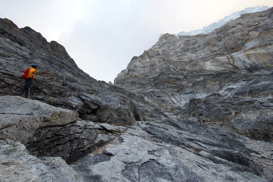
From the moment we scrambled to the base of Kaqur’s south face at 5,200 meters, we could see the rock was excellent. The same high-quality granitic gneiss (so it seemed) that we had found while acclimatizing on a neighboring 6,226-meter peak extended to the summit of Kaqur—information that could only be gleaned in person. Most of the basin and side valleys below Kaqur, apart from discrete contact zones with neighboring schist, seemed to have similar rock. It could have come straight off Mt. Moran in the Tetons.
We spent a week scoping the southwest arête from various angles and at different times of day, formulating our plan for bivouac sites and tactics. In base camp one morning, we saw a giant serac fall from the mountaintop, creating a huge debris zone across the bottom of the south face and confirming our choice to hug the arête. The two biggest puzzles were the middle rock section, with obvious snow-covered ledges but smooth, compact rock in between, and the upper headwall—the steep crown lording over the subrange. We grew convinced that there were enough features to pull it off.
We joked that our basic tactic would be Heavy and Slow, rather than Light and Fast. We each packed 11 pounds of food, plenty for five to seven days. We prioritized selecting the best bivy sites to stay well rested for the upper headwall, the obvious crux, rather than climbing until dark each day to gain meters. We hoped this would give us three relatively flat places to sleep: a thin, shaley ledge, which would probably fit a tent, after we raced up the lower slabs, and the diggable (we hoped) bottom and top of the snowfield separating the headwall from the lower serac band, with a Dyneema ice hammock supplementing whatever ledges we could chop.
My feet and Ryan’s are within one size of each other, so we’d share rock shoes for leading, although we anticipated climbing mostly in boots. To reduce weight, we packed a single synthetic quilt for two people, with a nylon floor that Ryan had sewed on to retain warmth, plus one hoodless sleeping bag. We had a small double rack, with extra pitons and nuts for rappel anchors. Ryan has a taste for homemade metal: I’m still not sure whether he found some of his pitons in a back-alley smithy in Thamel or yanked them off street signs at home in Bozeman.
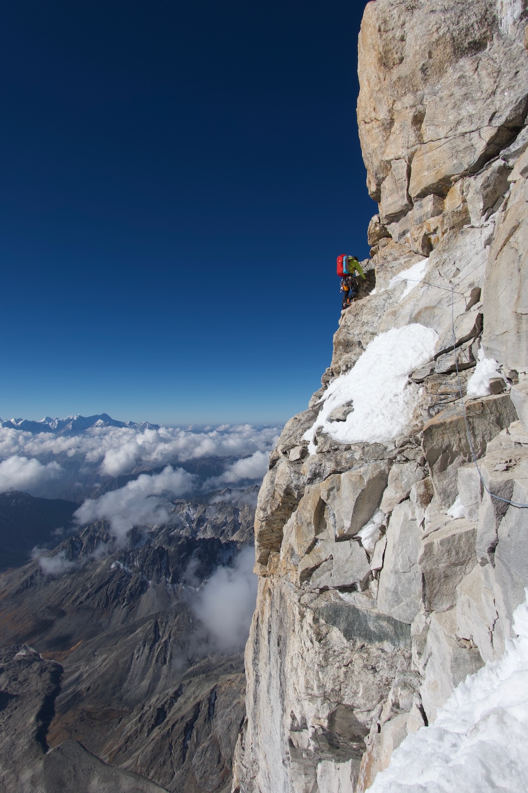
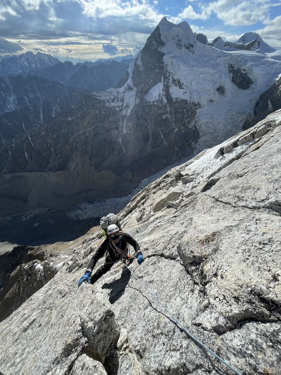
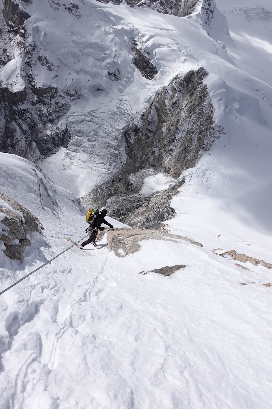
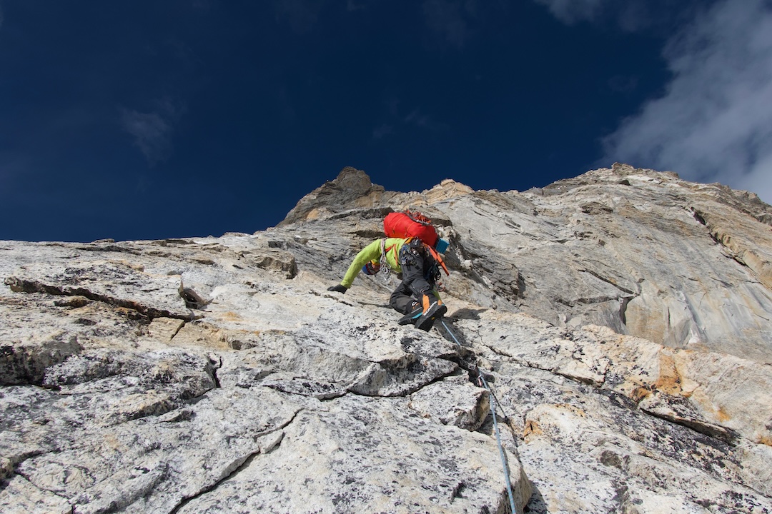
On day one, October 15, we three soloed about 1,500 feet of fourth- and low-fifth-class ramps and short steps to reach an overhanging chimney at the first cliffband. While an easier path lay through a drainage gully 50 yards right, it was exposed to serac fall, whereas the chimney was shielded by a buttress. Ryan led two pitches at stiff 5.10 in the rock shoes, including a laser-cut offwidth that had us laughing in disbelief at its high quality. As we followed, Matt and I skated off overhanging and crimpy sections in our double boots.
A couple of hundred feet above was a sloping band of red talus at 5,800 meters, where we stopped for the night after chopping out the frozen ground to fit the tent. The next morning, our MSR Reactor stove (a veteran of several trips at high altitude) failed catastrophically, apparently because of a thermal trip, an internal mechanism to prevent overheating that cannot be field-repaired once triggered. Fortunately, we had stashed a spare, if dinky, PocketRocket stove at the base, but getting it would require descending over 600 meters and fixing ropes to facilitate a return trip that same day. We had three more days of a bluebird forecast before an unsettled pattern moved in—losing a whole day could jeopardize this summit window. But no stove, no go. We bit the bullet and spent the day yo-yoing down and back up.
Staying attuned to your own motivations and risk tolerance is the only way to return repeatedly to big-mountain environments. While we were in base camp and acclimatizing, we had received the news that Michael Gardner, a fellow guide and a friend of Matt and Ryan’s, had passed away in a fall on Jannu East, in far eastern Nepal. His death deeply affected our team. Now, up on the mountain, Matt was discovering that, at that particular moment, his compass was not pointing toward Kaqur Kangri. I’m grateful that reaching that difficult conclusion deepened rather than strained our friendships. “Would something make the difference to change your mind?” I asked. Matt reflected, quiet, and then replied, “Maybe just time.”
After we retrieved the spare stove, Matt returned to base camp to explore side valleys and alternative objectives, while Ryan and I continued upward.
To begin our third day, I led perhaps ten pitches (up to 5.9) in boots, steep and occasionally loose enough to warrant pitching it out. We zigzagged up run-out edges and ledges on a triangular panel at the corner of the west face, pulling through several roofs and stacked blocks that moved us past overhanging cliffs. It was amazingly fun, moderate rock climbing, mostly in the sun in bare hands.
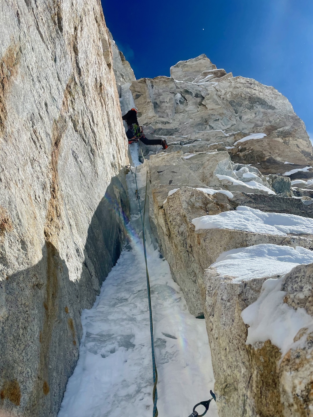
After the surface turned to plastered névé and ice, we put on crampons and Ryan took over for a block. We simul-climbed until sunset, at about 6,200 meters, at the base of the hanging snowfield on the south side of the arête, then hacked out a ledge from bullet ice. The first serac band was now below us.
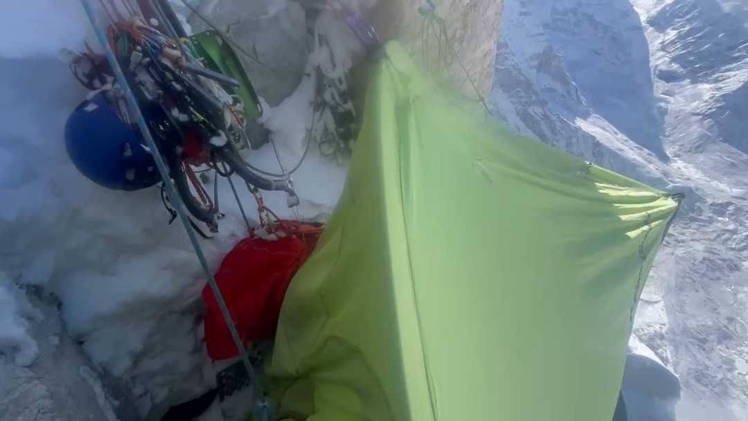
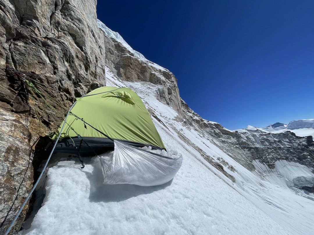
The next day, Ryan led a simul block up solid névé with small penitentes glued to blue ice, just to the right of the plunging edge of the arête. Our calves burned. At the top of the snowfield, we reached a shallow ice cave at 6,500 meters, with a small rock roof, and enlarged it into a luxurious, flat bivy, right at the base of Kaqur’s spectacular crux headwall.
“Morning, sunshine,” Ryan said saccharinely, waving at me from the opposite corner of the tent. We brewed coffee and watched the distant summits of the Dhaulagiri group glow in the first light.
Kaqur’s headwall showed several potential lines. While there seemed to be obvious ledges and corners to the right, they were closer to the upper seracs and had some blank sections. We stuck to the arête, along a semicontinuous weakness.
We had planned to complete the headwall in one long day, but the only appreciable precipitation of the expedition arrived while we were on the crux pitches, with six sticky inches falling over 36 hours. Already-sustained dry-tooling became somewhat more sustained as we swept and blew snow off pick slots and frontpoint divots. We completed the headwall in eight mixed pitches over two days.
To start off, I got lucky with the route’s best pitch, a glorious corner that would be a classic at any mixed crag: My bare right hand jammed up gear-swallowing cracks while my left hand threw an ice tool over a series of umbrella bulges of water ice. I could only giggle in the sunshine and shake my head. I said to Ryan, “I think that pitch is in the new Kaya guide to Ouray, isn’t it?”
As the weather moved in, I led into twilight on what turned out to be the crux pitch, up 60 feet of offwidth and chimney, with unprotectable ice in the back. The bottom of this feature flared open, with no footholds. We were stuck momentarily. After three abortive free attempts, and not wanting to break my ankles, I hammered in a knifeblade. I could step on it only after chocking my left hand behind an ice jam and cocking a drop-knee. The rest of the pitch (“pretty fucked,” Ryan recalled fondly the next morning) required similar scrounging, arm-barring, and tenuous high-steps.
I belayed Ryan from a sloping nook beneath another icy chimney and dihedral. After the prior block of leads and five days on the face, I was fried, so when Ryan arrived, he took over digging most of the bivy. A sharp piece of ice sliced the tensioned ice hammock as we loaded it. Then one of our tent poles snapped. But we still had enough room to curl tightly on our sides.
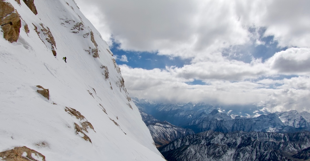
Ryan led the next day, clawing his way with occasional aid up two overhanging, brittle pitches of ice and then traversing around a final overhang. We exited the headwall on a ramp of moderate water ice, in light snowfall and heavy spindrift, and camped on the summit plateau. It was -5°F, and the wind blew steadily at about 25 mph all night.
On the morning of October 21, we left our packs and walked for an hour in sunshine up the snowy summit ridge, reaching the top on our seventh day on the mountain, most likely only the second team of climbers to stand there. The edge of Indian Kumaon, nearby Tibet, and central Nepal defined the horizon. For ten brief minutes, we savored this very involved approximation of walking on the moon and then began our descent.
We reached the base in one day via the northwest ridge and a west-facing slope below the north col, mostly downclimbing and making about a dozen rappels. This descent line would make a lovely fast ascent in the right conditions.
Matt, a mensch, left a headlamp lit for us at the base and waited all evening to meet us with extra food. Two days later, six mules returned to base camp and we all started walking out.
Objectives like the southwest arête of Kaqur Kangri used to be what most climbing was: trying something kind of hard, an inconvenient distance from home, and relying on imagination as much as effort to turn a thing dreamt into a thing done. There are still plenty of places to contrive that same experience. We just have to look harder—and be willing to court risk in an unpredictable operating environment.
Our team didn’t have what we’d consider a close call, but in debriefing, I still counted 23 discrete times when the risk ticked up. A mule nearly broke my knee with a kick when I tried to bring it into camp one morning. On our first day of climbing, we hustled up a ramp that was probably at the outside edge of the ricochet zone of the upper serac band. Two days later, Ryan and I both simultaneously realized that we were pushing our unroped luck on low-angle but hard-frozen talus above the west face. “If we slip here, it’s to the bottom, eh?” I said.
Of four minor rockfall incidents, we mitigated two by our choice of protected belays and bivvies. Another was friendly fire: On rappel, I chucked a baseball-sized rock so the ropes wouldn’t dislodge it. But I misaimed, and the rock bounced down the snow slope and nailed Ryan in the shoulder. I reasoned that Ryan had probably done something in a prior life to deserve getting punched in the clavicle. He was less sure.
On day three, below the snowfield, we pulled through suspended, stacked blocks in a roof that would have chopped the rope had they dislodged. On the upper headwall, my ice tool tethers got tangled behind a cam after I had campused out a diagonal rail. I couldn’t reverse the move, and I couldn’t continue until I had unthreaded the tools. Half growling, half screaming, I locked off on one arm, frontpoints screeching, and freed myself. When he followed, Ryan simply lowered out and jugged.
On the descent, Ryan and I had probably our riskiest moment when we crossed a 40-foot-wide wind slab partway down the upper northwest face. It appeared suddenly, a shallow pocket of cross-loaded danger in an otherwise stable snowpack. The tension on the slope and the soft, hollow thump as our boots and ice tools pressed through the snow put us both on edge. But with no other signs of failure or propagation, and a morning of downclimbing a similar aspect and angle above us, we each judged it safe enough to proceed.
An hour before we regained the base of the mountain, fed up with navigating the messy corners of the final glacier, we briefly but obtusely committed to soloing steep glacial ice, embedded with crushed pebbles, as we traversed 15 feet above the bottom of a closed crevasse. We were spurred on by Matt’s tiny light in the distance and the promise of fresh Snickers. Perhaps a week on the mountain and the tedious descent had dulled our nose for risk.
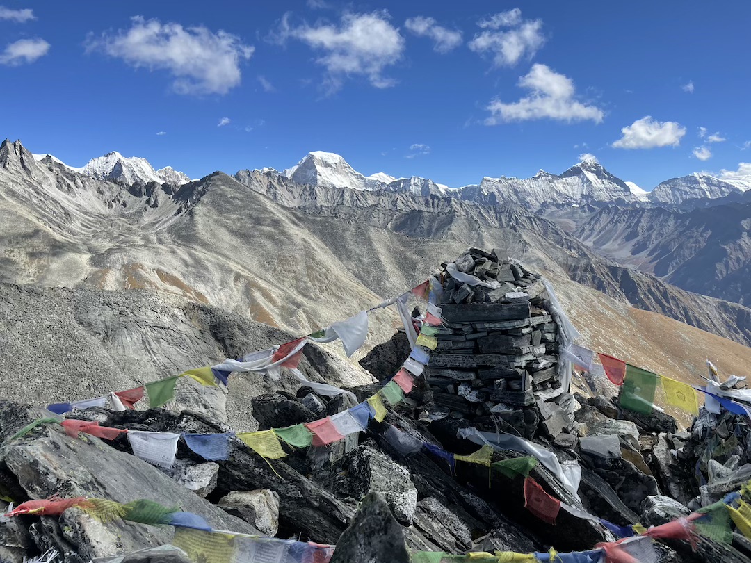
Three days later, we stopped at Chyargo La on the trek back out and took in our final view of Kaqur. I crouched beneath fluttering prayer flags to lounge against a rock, my fingers getting sticky pulling globs of gulab jamun out of a can we’d saved until now for a treat. Kaqur’s summit seracs glinted in the mid-day sun from what seemed like a very long ways away. Matt and Ryan laughed as I passed them the can for a shot of syrup to wash it all down.
SUMMARY: First ascent of the southwest arête of Kaqur Kangri (6,859m, 29.766N, 82.750E), Mugu District, Nepal, by Spencer Gray and Ryan Griffiths, with support from Matt Zia. The ascent (1,670m, ED+ M7 WI5 A0, with 5.10 rock and steep snow) was from October 15 to 21, 2024, with descent via the northwest ridge on the final day.
ABOUT THE AUTHOR: Spencer Gray is an American climber who holds lowball butt-scrapers and alpine choss in equally high regard. He works in public policy related to energy and natural resources, and is based in Seattle.
Media Gallery