Odyssea Borealis
Greenland, East Greenland, King Frederick VI Coast
Matteo Della Bordella, Alex Gammeter, Symon Welfringer, and I reached Tasiilaq in East Greenland in mid-July. Our climbing goal was the huge, unclimbed northwest face of Drøneren (1,867m), near the head of South Skjoldungen Fjord (Inugsuarmiut Fjord). The mountain is more than 300 kilometers southwest of Tasiilaq by air and much farther by sea. Our plan was to kayak there and back, adding significant uncertainty to our adventure.
Although the Skjoldungen area has been settled at various times, it has had no residents for more than 50 years. The climbing history in the area centers on American Mike Libecki, who made six journeys to Skjoldungen by motorboat, from 2002 to 2017, and completed first ascents on various formations, some solo and some with partners. During his final trip, Libecki and friends started up a very steep wall on the northwest face of Drøneren, which he had labeled Granddaddy Tower, but had to abandon the attempt after 300 meters and switch to a smaller objective because of poor weather and lack of time—sea ice had delayed their journey to the fjord by ten days.
Unfortunately, the conditions were similarly bad for our planned approach. Record pack ice blocked many East Greenland settlements when we arrived, making navigation impossible. We waited for days in Tasiilaq.
I had paddled a kayak to climbs in East Greenland during three previous expeditions (see AAJs 2015, 2017, and 2022), and, ironically, I had always said this was much better than being on a classic Himalayan expedition, because there is no downtime. In the Himalaya, the base camp is reached quickly, with the support of local helpers, and if the weather is bad, you just wait it out and let the cook spoil you. But when you’re kayaking in Greenland, you have to cook for yourself, look for a suitable camp every evening, and even in bad weather keep paddling toward your destination. There is always something to do—though only, of course, when the sea ice permits you to travel.
A piteraq, a katabatic storm from inland, finally relieved us and pushed the pack ice away from the coast. Knowing that the ice could close again at any moment, we opted to begin our journey by motorboat, starting on July 23 from Isortoq, about 60 kilometers west of Tasiilaq, and reaching a launch point for our kayaks another 90 kilometers down the coast on July 24.
We were finally alone in the wilderness! Long days at sea followed as we slowly paddled south. Huge glaciers and barren mountains lined the coast, while massive icebergs crowded the ocean.
Nothing was given to us; every day at sea was a surprise. One day, as we traversed a large fjord, the water’s surface started freezing. Soon, we couldn’t break the ice layer. With everyone pushing the leader’s kayak, we barely managed to get back to shore—escaping a long night out on the water. Another time, we were almost crushed by ice floes as the tide changed. After the sixth day of paddling, a storm pinned us in the tent for 60 hours, all of which we spent hoping the nylon wouldn’t tear. The wind even sent small rocks flying through the air. Just before the storm’s peak, we built a small platform under an overhanging rock—the most sheltered spot we could find.
We started each morning with the open question of what surprise the day would bring. Nobody thought about the climbing to come—the sea and the Greenlandic wilderness had a firm grip on us.
With no designated leaders, our team functioned like a small democracy, with all its advantages and disadvantages. Even deciding where to take the next pee break could lead to long discussions. We were an intense group, with strong opinions and slow decision-making processes. It didn’t always make for a good atmosphere, but it was the key to our success and safety in this punishing environment. I look back with pride at the decisions we made. They were painstakingly discussed, and always good and focused.
After ten days and 300 kilometers of kayaking, we finally reached our destination. At the head of Skjoldungen’s twin 45-kilometer fjords is Dronning Marie Dal (Queen Marie Valley), which is like an oasis compared with the barren landscape we had been passing; now we saw lush vegetation, clear streams and rivers, and beautiful mountains—a picture-postcard idyll. Relieved, we beached the boats, set up base camp close to the water among a handful of big boulders, and turned our thoughts toward climbing.
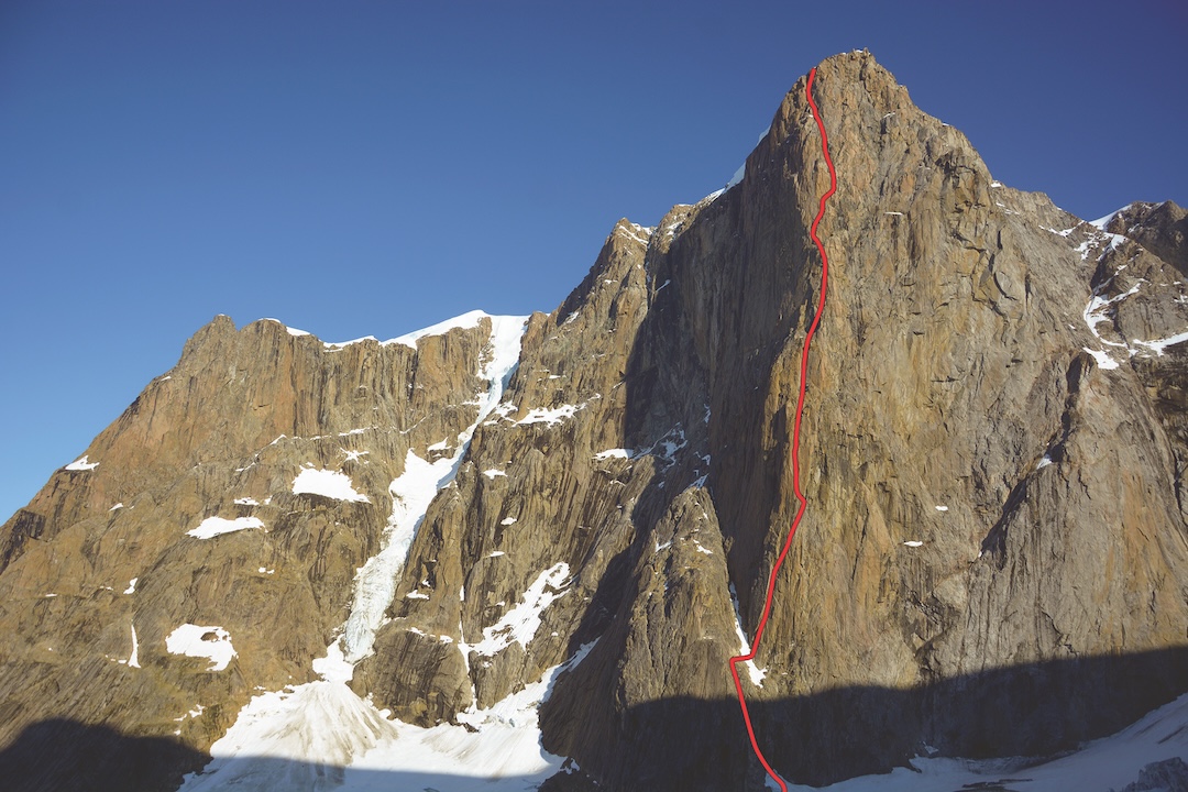
Drøneren—the peak’s name on the official Danish map, meaning “Drummer,” perhaps referring to the sound of falling ice and rock—is a huge, complex massif. The northwest face is hidden in a side valley, invisible from our camp, and we were impatient to ferry our gear over and see the wall up close. The approach through the flat valley floor had its own special charm. To keep our clothes dry, we waded naked through rivers and swamps, getting stung by thousands of sand flies. Farther up, we climbed over moraines and firn fields to the glacier below the wall. As if to welcome us, shortly after our arrival, a huge boulder fell from the left part of the wall and crashed spectacularly at its foot. After this, we quickly agreed to stick to the central pillar for our climb.
To save space and weight, we had packed only two inflatable portaledges and a few ropes for fixing, including our tagline and dynamic ropes. On the last half day of predicted good weather, on August 6, Matteo and Symon fixed the first five pitches. This first part was mainly easy but sketchy ground on semi-solid rock. Subsequently, the weather became very unsettled. We usually had one day of good weather followed by two days of rain.
On another day, we climbed up to fix the last of our ropes. This time, Alex and I reached a point on the pillar where there were no more cracks. Inspecting photos of the wall we’d taken from below, I saw a small crack appearing ten meters left of our position. I was very keen on this challenge—a hard but logical crux across a run-out traverse.
At first, I tried to climb free and onsight, but I soon realized the Pecker I’d placed wouldn’t be good enough, so I aided for one meter. The rock was flaky, and I ended up linking up four shallow Peckers, with the equation that “four times bad equals one times good.” After some hesitating, I decided to go all in and free climb the traverse. Although there were some nice crimps, the rock was crumbly. Right before the crack, a foothold broke. With a last, panic-driven effort, I caught the crack and placed a good cam. Even though it was only a few meters long, this crux pitch will forever be written in my climbing memory book.
Matteo checked out the pitch on second, did some cleaning and ticking, and gave all the beta to Symon, who freed the pitch with ease. We proposed a grade of 7b R for this crux pitch.
By now we had fixed around ten pitches, using every meter of rope we had.
We’d had our hands full ever since leaving Tasiilaq—exactly what I like about these expeditions. Unfortunately, after these first efforts, there was no weather window in sight to finish the climb. During one rainy day, a cruise ship came by, breaking the tedium at base camp. Armed to the teeth for defense against polar bears, the guide and well-heeled guests visited us briefly, saying they would soon have to return to the ship to eat in one of the three restaurants on board. Unfortunately, we weren’t invited, but at least they left a case of beer for us to enjoy in camp.
We knew the base camp bouldering very well by now, and Matteo had perfected the technique of catching fish with an ice tool. Nevertheless, our motivation decreased with each day we spent waiting to climb.
In the meantime, it snowed a lot in the mountains—the peaks around us looked ready for ski season—forcing us to abort one attempt early. During another attempt to move beyond the fixed ropes, a vicious storm came roaring in, catching us by surprise. We were already high on the ropes when small rocks started to fall. After a fridge-sized rock passed by, we retreated again. One of our fixed ropes had been cut by falling rocks.
Running low on food and time, we had a decision to make: Either we would bail on the climb and start the return trip by kayak now, or we’d allot our remaining time to climbing and call the motorboat operator to arrange a pickup closer to base camp. We opted for one last chance to climb, giving up the plan to kayak all the way back.
On August 15, we abandoned a third attempt due to rain. It was only on our fourth attempt, on August 17—pushing right up against our deadline for leaving the fjord—that we were able to give a real effort.
When we finally reached the end of the fixed ropes again, Symon and Matteo climbed quickly into the new terrain. Meanwhile, Alex and I carried the gear. Our climbing strategy was: one leader and one follower with Jumars, and then the second party following with Jumars and hauling. It was great to finally be on the wall and giving it our best shot! Challenging pitches on good rock were followed by ledges and sloping terrain with scree and brittle rock. A steep pillar offered complex climbing with great exposure. Late in the evening, we reached a ledge that we had scoped as a bivouac site. Unfortunately, it was sloping, and we had to dig in the scree and snow to find a place to sleep. The mood was finally good, though, and motivation remained high.
The next day, Alex and I climbed ahead. It was cold, and the higher we got, the more snow we found. Steep, snowy gullies led us to the left. Although the terrain became easier, the conditions got worse and worse. Alex climbed some mixed pitches—without crampons or an ice axe. A final headwall of about 100 meters towered above. Fortunately, we found a corner that was largely free of snow. Overhanging climbing with maximum exposure led to the foot of the impressive ice cap overlaying the summit plateau. What a way to finish the wall!
A hundred meters later, we stood on the summit. Drøneren is a high, free-standing mountain with commanding views: We could see the vast Greenlandic ice sheet, the many impressive mountains around us, and the Arctic Ocean off in the distance, shimmering like silver.
We rappelled to the bivouac in the last light of the day. That night, we had the best summit party, reveling in our success as the northern lights danced above.
The same day that we reached base camp, tired and satisfied, we received bad news via our satellite phone: Our hoped-for motorboat ride back out of Skjoldungen Fjord was not possible, due to its distance from Tasiilaq. So, we packed our things and loaded the kayaks. We still had enough food for four days and wanted to make it at least half of the 300 kilometers back north, within range of a boat pickup.
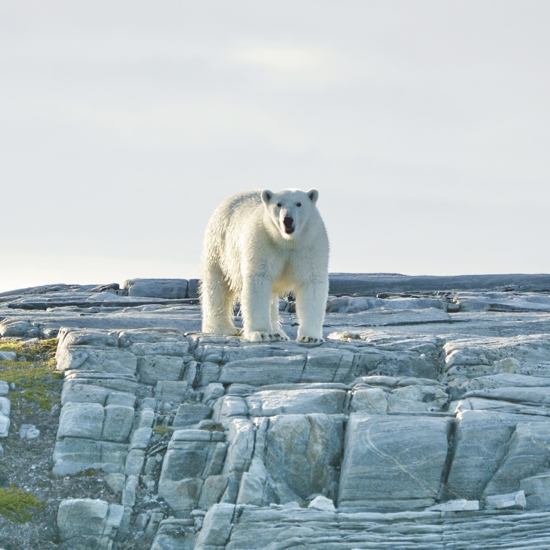
Just as we were getting into the kayaks, a very curious polar bear appeared right behind us. Alarmed, I took out my rifle and fired a warning shot. The bear continued toward us. I fired a second time. Finally, the bear retreated, and we hurried to get into the kayaks and say goodbye to our base camp oasis.
During the following days at sea, we had mostly good weather but decided to keep night watch in case of more bear visits. After four days and paddling 150 kilometers, we set up our last camp and waited for the boat. But no one came. It wasn’t until evening that we learned no one was prepared to pick us up! Many panicked phone calls later, we managed to arrange another boat.
The next morning, at dawn, another polar bear tried to break into my kayak, but it ran away when I screamed. In the afternoon, a boat arrived, and the tension of 35 days in the wilderness vanished in an instant. Our odyssey was over.
SUMMARY: First ascent of the northwest face of Drøneren (1,867m), near South Skjoldungen Fjord (Inugsuarmiut Fjord) in southeast Greenland, by Odyssea Borealis (1,200m, 35 pitches, 7b R). The ascent was by Matteo Della Bordella (Italy), Alex Gammeter (Switzerland), Silvan Schüpbach (Switzerland), and Symon Welfringer (France). They began work on the route on August 6, 2024. After fixing ten pitches, the team completed the route in two days, summiting August 18, and descended the next day. Their 35 days of wilderness travel included 450 kilometers of kayaking. (See photos of more peaks and walls in this area at the AAJ website.)
ABOUT THE AUTHOR: Silvan Schüpbach lives in Thun, Switzerland, and has made expeditions to Nepal, Pakistan, Greenland, and Patagonia. Originally a biotechnology engineer, he now works for the Swiss Alpine Club and as a mountain guide.
Media Gallery