

Huandoy Sur, South Face
Peru, Cordillera Blanca
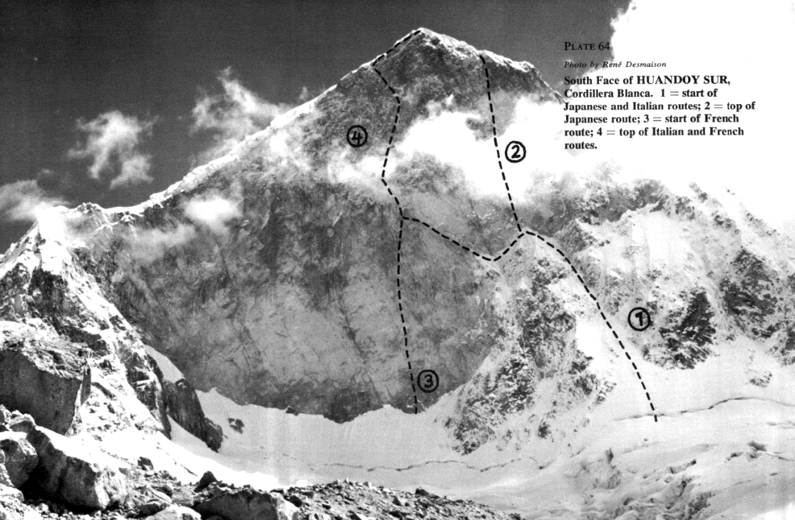 On June 8 we arrived at Base Camp at 12,500 feet on the Llanganuco Lakes. We should have taken time for acclimatization, but perhaps because we knew the Japanese were already on the wall, of which we caught glimpses through the clouds, the next day we started up the path which led to Camp I at 15,750 feet near the edge of the ice. (See the Japanese report here.) After a descent of 150 feet, the route continued up the ice of the glacier for 1000 feet to the bergschrund below the right (east) side of the face (east of the precipitous cliffs that fall straight from the summit.) Camp II (I 6,750 feet) was placed there on June 13, primarily as a supply dump. We continued up the ice and snow spur with some passages of 65’ to 70° and an average of over 55”. The route to Camp III (18,550 feet) at the top of the spur was prepared in the next three days. On June 16 Lorenzo Lorenzi, leader of the expedition to HuascarLn from Cortina, arrived at our Base Camp with sad news. “Two of ours are lost, doubtless dead. It is too dangerous to go on.” Silence fell on our tents. Our youths did not climb again until after the departure of the Cortina party and the scope of our undertaking became more intense in memory of our tragically killed friends. We fixed ropes as we descended some 250 feet diagonally left from Camp III on a 70° slope. Meanwhile we also tried to protect Camp III from rockfall caused by the Japanese directly above us; we dug a snow cave into the crest of the spur where we could take refuge. I don’t understand why, having arrived first, the Japanese had attacked the wall directly, being forced to use exclusively expansion bolts. But this was their affair, and we were happy that they had left free for us the most logical and classic route on the face. At the end of the diagonal descent we found an 800-foot traverse, which led to the foot of the rock pillar visible from Camp III. The route continued diagonally left up very difficult free and aid climbing. At one point a 35-foot metal ladder was used. (The Editor has summarized in his translation the very detailed route description, which he believes is being published in full in Rivista Mensile.) The crux was a vertical dihedral, climbed with bongs and wedges. Very steep ice sections were interspersed with rock. To advance or see others advance only 150 feet a day, with gritted teeth, up this virgin territory where six other expeditions had failed, was oppressing. It was tough to climb back to Camp III every evening up the fixed ropes for 350 feet of nearly vertical ice. The next problem after climbing the pillar was to find a site for Camp IV. Eventually, on July 4, Camp IV was placed, nearly hanging in space, at 19,350 feet. On July 6 Agostino Da Polenza and Renato Casarotto left Camp IV at nine A.M. The climb continued with great difficulty in a straighter line upward. Much of this section was on monolithic blocks with vertical and horizontal strips of rotten rock between them. The cracks here, as lower, were filled with ice. They finally arrived at the left base of the black stains on the rock below the summit. They tried to continue straight up but rotten rock turned them to a narrow ice couloir on the left. More difficult mixed climbing at last led to a rock and ice couloir that let them emerge without further difficulties on the summit ridge at five P.M. They climbed the snow ridge and got to the top (20,223 feet) at sundown. We were on the mountain from June 9 to July 9, from Base Camp. We climbed on 22 days. We placed 350 pitons, 350 feet of ladders and 35 stirrups. The other members of the expedition were Dr. Felice Boselli, Mario Dotti, Giuseppe Baracchetti, Giuseppe Buizza, Giuseppe Gotti, Antonio Camozzi, Gianni Scarpellini, Giovanna Brissoni Dotti, Caretta Traverso Casarotto and I as leader.
—FRANCO NEMBRINI, Club Alpino Italiano
Media Gallery