
Avalanche— Late-Season Wet Loose Slide
California, Sierra Nevada, Hurd Peak
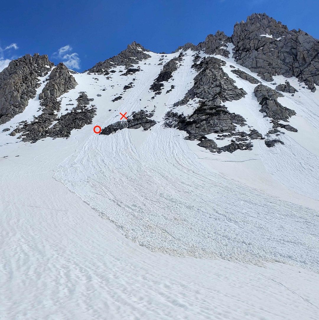
On the morning of June 14, a party of two was ascending the north side of 12,237-foot Hurd Peak when they began to notice signs of instability. Skier 2 reported that they discussed the deteriorating conditions and the possibility of turning around. Soon after this discussion, a natural wet loose avalanche released at about 11,940 feet, about 400 feet above the party, and swept both individuals down the slope. Skier 1 was carried over a cliffband, and both parties were partially buried.
After coming to rest, Skier 2 had a hand free and was able to clear their face, dig themselves out, and initiate a search for Skier 1, who was partially buried with a leg exposed. Skier 2 was able to locate and extract them quickly. After assessing Skier 1’s condition, Skier 2 initiated a rescue via an inReach at approximately 11:45 a.m.
Skier 1 sustained critical injuries during the avalanche, and their condition deteriorated with time. The rescue was complicated by continued avalanche threat. During a subsequent avalanche, Skier 2 was forced to retreat from the toe of the debris to nearby safety before returning to uncover Skier 1 a second time.
Inyo County Search and Rescue arrived on the scene in midafternoon, and Skier 1 was airlifted to the hospital. Unfortunately, despite the heroic efforts of Skier 2 and the rescue team, Skier 1 did not survive their injuries.
ANALYSIS
This season’s record-breaking snowfall and abnormally cold spring led to substantial snow coverage lasting well into the summer months. This allowed for better-than-usual access for backcountry skiers and riders. It also meant the snowpack was subjected to atypical weather inputs, including intense solar radiation, summer rain and snow showers, and very warm overnight temperatures. This event is a tragic reminder that the snowpack remains dynamic—and destructive avalanches are still possible—during the spring and summer months.
Overnight temperatures measured at the South Lake weather plot (9,600 feet), near the site of this incident, remained near or above freezing for several days leading up to the accident. In early summer, the north face of Hurd Peak receives solar input shortly after sunrise. The shallow nature of this slope and exposed rock features encourage rapid warming. Cloud cover on the evening of June 13 may also have limited the overnight refreeze potential.
It’s also important to note that the approach and lower flanks of the north face have a northwest aspect and are partially protected from the morning sun. Snow in the upper start zone thus warms quicker than snow along the approach. The first signs of instability may not be observed until skiers are fully exposed to overhead hazards.
On the morning of the accident, a solo skier climbed and descended the face at approximately 9 a.m., observing signs of impending snow instability, including wet surface snow and deep boot penetration on the climb. This skier triggered a small wet loose avalanche at the top of the path and carefully descended the bed surface. The skier did not see the party that would be involved in the accident later that morning.
This accident is a tragic reminder that snow conditions can change dramatically from one day to the next and that even a relatively small avalanche can have devastating consequences in steep and rocky terrain. (Source: Eastern Sierra Avalanche Center.)
Media Gallery