Oierlizuoke (Khan Yalik), Northwest Face, Attempt
China, Xinjiang, Kun Lun, Aksai Chin
In 2024, my company, Feeding the Rat Expeditions, obtained the first permits to visit the Chinese side of K2 since 2011. However, in October, immediately before our planned departure, the permits were unexpectedly suspended, for reasons only described as “military.” Eager to help, the Xinjiang Mountaineering Association laid out other options that would fit the logistics we already had in place. One of the offerings was the Aksai Chin region, which we grabbed before they changed their mind.
We settled on the East Karakash mountains of the northern Aksai Chin. These are probably the highest mountains in all of the Aksai Chin, though the only named peak is Oierlizuoke (6,700m, 35°50’51.11”N, 79°34’29.57”E). This area has a number of summits around 6,500m, but climbing here had never been formally allowed. [The mountain described here is better known as Khan Yalik and was climbed in 1996 and possibly earlier. Most sources use the name Oierlizuoke or Qierlizuoke Feng for a 6,802m peak that is 22km northwest of this mountain. See the notes below about historical ascents in this little-known range.]
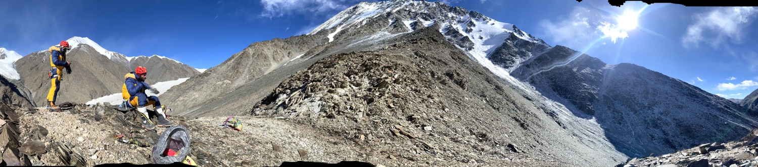
Benji Brennan and Sam Wieske (Australia), Alex Tang (China), Tom Rospabe (France), Marco de Vecchio (Italy), and I acclimatized to 5,300m in the Tibetan ranges of western Sichuan, then flew to Kashgar in mid-November and drove to a point south of Oierlizuoke. Following the East Karakash River, we made multiple carries over several days to a base camp at 5,200m.
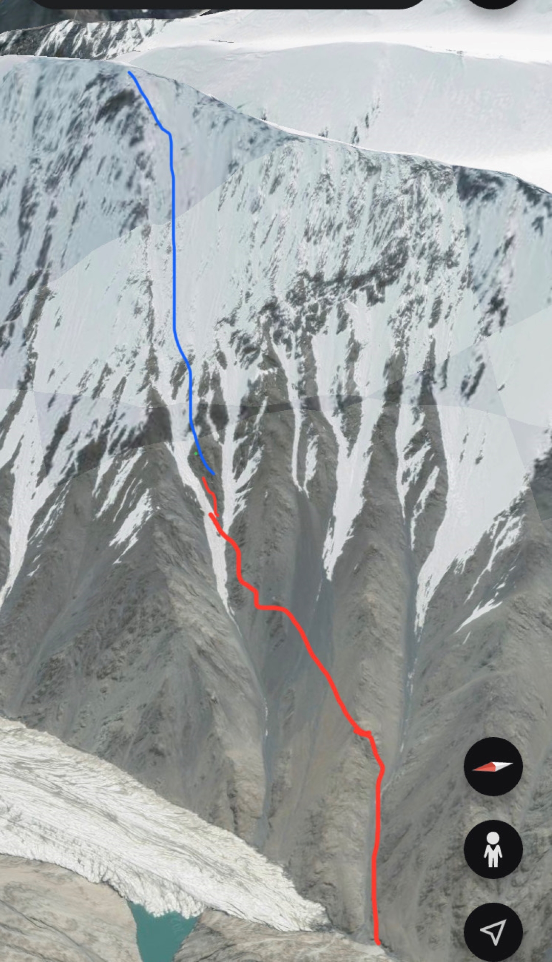
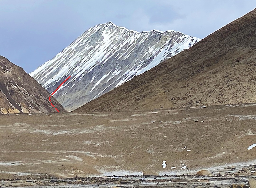
In the upper reaches of the river, the mountains rise around 1,600m. Oierlizuoke is a narrow, dorsal-fin ridge running northeast-southwest, with the southeast and northwest faces both rising from glacier basins.
We attempted the central northwest face rising above the East Karakash Glacier. Our line was a snow and ice runnel, starting about 500m above the glacier. The gradient began at 45°, then steepened. The climbing was not technical, and as the temperature never got anywhere close to rising above freezing, rockfall was minimal.
Our high point was on November 29 at around 6,000m. At base camp, temperatures had already fallen below -30°C inside tents (around -25°C during the day). Our equipment was up to the task, but the weeks above 5,000m were starting to wear. We retreated and then drove more than 4,000km home to Chengdu.
—Ed Hannam, Australia
NOTES ON THE AKSAI CHIN
The mountains of the Aksai Chin are part of the greater Kun Lun and remain little explored. Among commonly available sources, only Google Earth labels Oierlizuoke (Qierlizuoke Feng) as the 6,744m mountain attempted by the above expedition. Most other sources give this name to a higher (6,802m) peak around 22km to the northwest.
The mountain attempted in 2024 is better known as Khan Yailik and was climbed in 1996 by Hitoshi Yamaoka’s seven-member Japanese expedition after a reconnaissance the previous year. They climbed the northwest face, considerably farther to the right of the 2024 attempt, reaching the southwest ridge at 6,400m and following it to the summit. However, certain scholars of these mountains, such as the Czech professor Josef Hala and the German researcher Eberhard Jurgalski, believe it was climbed much earlier.
In 1865, William Johnson, a member of the Survey of India, was tasked to survey the area of Kashmir. In August, he spent 20 days in the Karakash region of the Aksai Chin, during which he supposedly climbed Khan Yailak and a lower summit named Yangri Tag (6,599m), both for survey purposes. If confirmed, it would be a remarkable altitude achievement for the era. The end result of these endeavors was the “Johnson Line,” which put the Aksai Chin firmly within Kashmir. Although accepted internationally as the border between India and China, it was never, unsurprisingly, accepted by the Chinese, and it remains the root of Sino-Indian border disputes that continue to this day.
About 40km southeast of Khan Yailik lie the Cholpanglik peaks, three of which were climbed in 1989 by a team of Japanese climbers led by Kazuo Sasaki: Cholpanglik I (6,540m, 35°36'24"N, 79°56'51"E), Cholpanglik South (6,460m), and Cholpanglik Central (6,440m). A year later, in August, another Japanese team, led by Osamu Takahashi, climbed the oddly named Kor 65 (6,540m, 35°47'24"N, 79°35'36"E), which lies only 6km south-southeast of Khan Yailik.
In August 2004, a 10-member international expedition led by Randall Krantz climbed four peaks in the Kashugul Group, which they named Kashugul Pyramid (6,722m, 6,773m GPS, 36°01'21"N, 79°20'03"E, about 11 km west of the 6,802m Qierlizuoke Feng), Kashugul Nevis (6,642m GPS), Kashugul Lefty (6,553m GPS), and Kashugul Wyatt (6,436m GPS). These lie northwest of Khan Yailak and between the Kashugul River to the north and the G219 road.
In 2007, a two-person American-Swedish party attempted the 6,802m Qierlizuoke Feng via the west ridge but retreated from around 6,350m due to dangerous avalanche conditions. Two days later, they climbed Jiao Feng (a.k.a. Qierlizuoke South, 6,370m, 35°57'54"N, 79°26'41"E), just few kilometers south of Qierlizuoke Feng, via the northwest ridge.
—Lindsay Griffin, AAJ, with assistance from Matt Powell
Media Gallery