Cordillera Emperador Guillermo, New Routes
Chile, Northern Patagonia, Aysén Region
 The Cordillera Emperador Guillermo is located north of Coyhaique and a few kilometers west of the town of Villa Ortega. Despite the proximity to town, the range emanates a great deal of mystery and solitude. Spanning about five kilometers from southwest to northeast, the most prominent summits include Punta Rincón (ca 1,915m), Cerro Azul (ca 1,900m), Cerro Mesa (ca 1,941m), and Cerro Emperador Guillermo Norte (ca 2,100m), the tallest in the range. Climbing began here only recently, in the early 2000s, and has concentrated on the south and east flanks. For me, the range is an old acquaintance, which I first began to know in 2010.
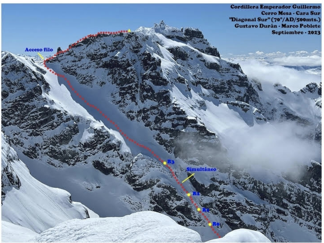
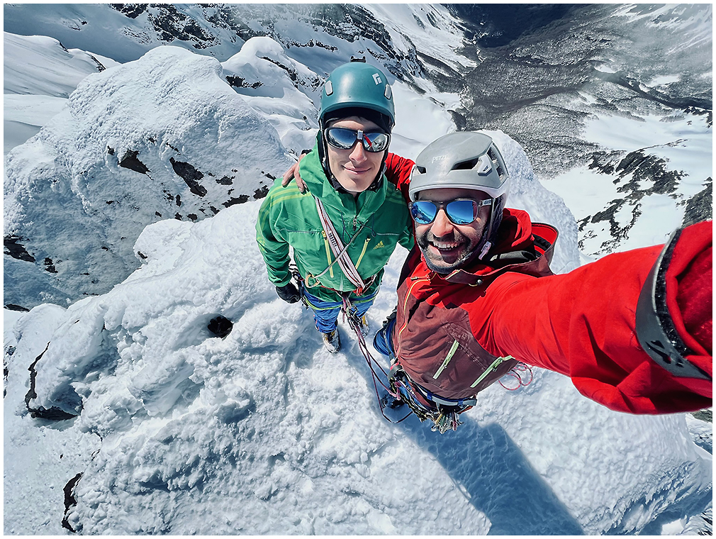
In mid-September 2023, I visited the range with Gustavo Durán, intent on climbing a new route on the south face of Cerro Mesa (45°19’06”S, 72°11’44”W). Cerro Mesa was first climbed by Francisco Croxatto and Samuel Esmiol in April 2005 (route unknown). Daniel Zapata and I made the second ascent, climbing the southeast face in December 2010.
With Gustavo’s 21 years to my 41, we achieved a good synergy based on vitality and experience. To approach, we followed the Río Azul, hiking south-southwest for three hours to a campsite at the moraine. The mountains were very heavy with snow.
The next day, we set off at 5 a.m., moving through the dark with snowshoes and headlamps. At 7:30 a.m. we reached a steep south-southeast-facing glacial ramp. I led two pitches of snow and ice up to 70°, then we simul-climbed for about 120m until reaching the upper ramp, where the slope and the exposure lessened. Nonetheless, the upper ramp demanded a lot from us. We felt tired and the cold was intense (I never took off my down jacket).
From the top of the ramp, we continued up the rocky south ridge to the summit, progressing around gendarmes covered in ice. At 12:15 p.m., we stood on the summit of Cerro Mesa, our wintertime effort resulting in a well-deserved reward: Diagonal Sur (500m, AD 70°). It took us three hours to descend, using one rappel to avoid the initial, steeper pitches.
In mid-October, Gustavo and I returned with the goal of climbing the east face of Punta Rincón (45°20’11”S, 72°12’32”W). I first saw this face with Eduardo Jara in December 2012, when we made the first known ascent of Punta Rincón. On that climb, we chose an east-facing gully north of the summit (climber’s right of the central east face); this led to an obvious col from where we rounded onto the west face, overcoming some rock steps in the final section. It had been a long time since a goal generated so much anxiety and uncertainty in me.
We followed the same three-hour approach and rested the evening before our climb. The next morning, we were on the move by 3:30 a.m. The snow was hard, progress was rapid, and we gained altitude easily up a left-trending couloir that leads toward the col on Punta Rincón’s southeast shoulder. As this gully steepened, it appeared that a diagonal, rightward-trending snow slope would lead us onto the east face. However, the slope turned out to be quite vertical and exposed for hundreds of meters, with snow of dubious quality. We opted for plan B: continuing up to the col, from where we could ascend the south face.
The col separates Punta Rincón from a likely unclimbed summit to the south that we propose to call Cerro Mirador (ca 1,700m). We decided to climb Cerro Mirador first, and we ascended snow slopes on its east-northeast shoulder to arrive at the summit by dawn. The summit is crowned by a prominent ten-meter rock step that we overcame to the east. On the summit, we enjoyed an incredible sunrise and analyzed the route we would attempt on the south face of Punta Rincón.
We first descended back to the col and then began zigzagging up the face between rock steps and ledges, keeping the rope mostly in our backpacks. Eventually, we anchored in the ice below the first real pitch, and Gustavo led a narrow, exposed gully to the upper snowfield. From there, it was my turn. After placing a couple of short ice screws, I used snow stakes to protect the steep slope. It was a perfect morning—cold, always in the shade, but windless—as we made our way up a forgotten staircase of the Patagonian Andes. We climbed one final steep section, using cams to protect the rocky exit.
On the summit ridge, the sun was shining brightly, offering some warmth to our extremities. The summit was close, about 60m away, but first we had to solve about eight meters of mixed climbing (M3). I did this without much style: After breaking through rime crust to place a couple of cams, I crawled the final meters. At 12:30 p.m., we both stood on the tiny summit of Punta Rincón. The descent by the 2012 route did not bring any major surprises, allowing us to reach our vehicle again at 7 p.m., exhausted, broken, but infinitely satisfied. We called our route Dos Generaciones (400m, AD+ 65°).
— Marco Poblete, Chile
NOTES ON THE CORDILLERA EMPERADOR GUILLERMO: The first reported ascent of Cerro Emperador Guillermo Norte (45°18’38”S, 72°10’57”W) was by Richard Mansilla and Ignacio Vergara in December 2013; their route was repeated in October 2016, by Pablo Cid, Sebastian Jans, and Marco Poblete. The route climbs the east face to the col between Cerro Emperador Guillermo Sur and Norte, then up the latter’s south side.
In April 2017, Hugo Castañeda and Martin Hatmann climbed a new route on the northeast ridge of Cerro Emperador Guillermo Norte over three days, using two bivouacs; they reported six pitches with maximum difficulties to 5.11. Cerro Emperador Guillermo Sur (ca 1,960m) may be unclimbed.
The other prominent summit of the range, Cerro Azul, located between Punta Rincón and Cerro Mesa, had its first recorded ascent in September 2012 by Hugo Espinoza and Marco Poblete, who ascended a northeast-facing gully to its summit; they called that route Canalón de los Coyhaiquinos (240m, 60°).
Media Gallery