Attempts and Ascents North of Kulusuk
Greenland, East Greenland, Schweizerland

Over ten days in August, Ben Kincaid, Kennon Kincaid, Scott Lockhart, and I explored the coastal mountains extending north from Kulusuk to the east of the lower Knud Rasmussen Glacier. We were supported by IFMGA guide Matt Spenceley, head of Pirhuk Guides. I was provided with limited financial support from the AAC’s Live Your Dream Grant.
Our expedition greatly benefited from the use of a rigid inflatable boat (RIB) and ample fuel to access various islands and points of interest on the mainland coast, otherwise inaccessible to larger vessels. We attempted four ascents, two of which failed due to potential hazards and issues with route selection; poor weather also reduced our available climbing time.
After an ascent of the previously climbed Inntugai (a.k.a. Tatsukajik) on the south side of Apusiajik Island, our next target was an unnamed peak at 65.66299°N, 37.00288°W (marked as 830m on the Danish Map but seemingly well over 900m), accessed from the north side of the same island. Although this mountain was previously climbed, we traversed the northeast ridge (Oscar’s Ridge), which we believe to be new. We generally moved together as two rope teams on the ridge, which was of mixed quality and low 5th class, then descended snow and a glacier system to the west and back north, resulting in a near circumnavigation of the peak.
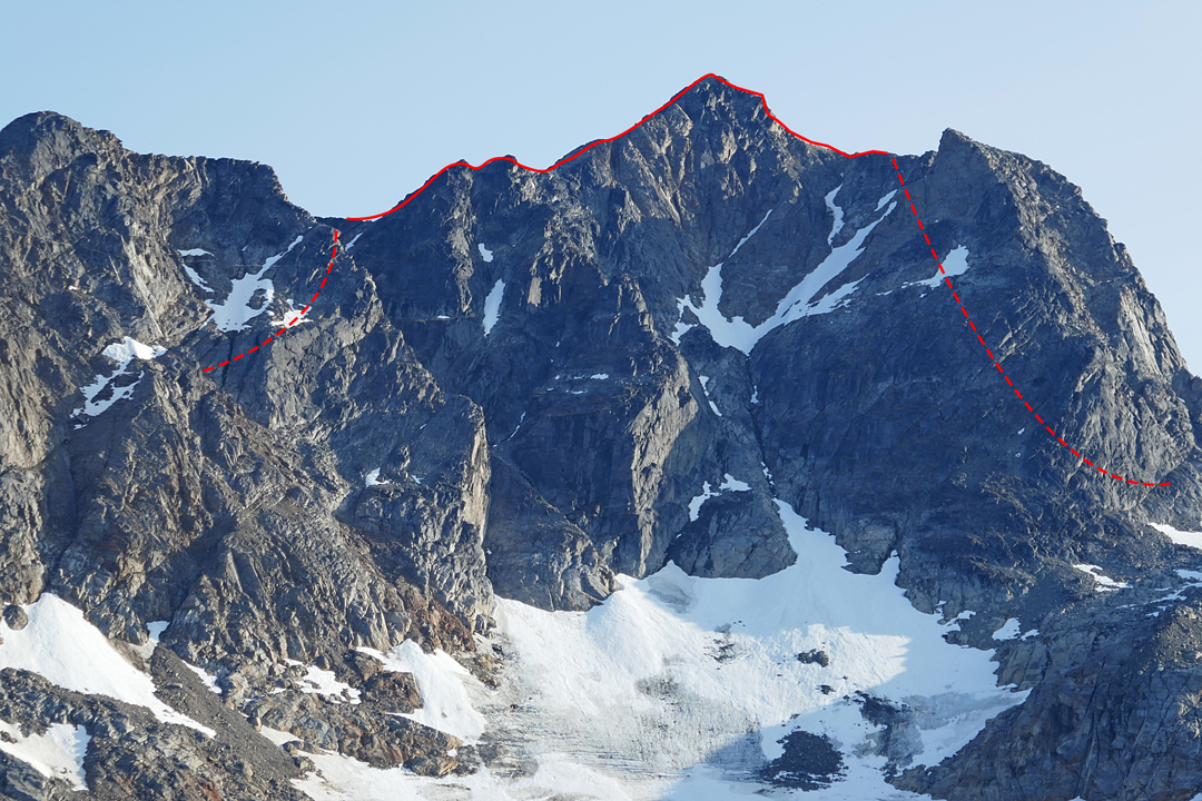
We later tried an unnamed peak (918m, 65.76611°N, 36.82814°W) on an island with no name on the map, southeast of Ikâsak Fjord. Route-finding was complex, due to dense fog on the maritime approach to the island and during the initial ascent from the southeast, resulting in poor route selection. An approach from the north or northeast would have likely provided much easier access and a potential non-technical walk-up. We climbed extensive unstable rock and moraine, eventually stopping on the east ridge at around 800m. The continuation looked loose with very limited protection. (See note below about an ascent of this peak.)
We then used the RIB to access the snout of the Knud Rasmussen Glacier. We followed the east side of the main glacier to the base of a side glacier flowing from the southeast, then followed a broken ridge to the south toward a summit at approximately 66.07584°N, 36.18338°W, which we were unable to reach in daylight. Although we had brought bivouac equipment, we decided to descend to the RIB. [Editor’s Note: Islands and peaks north of Kulusuk received much attention in the 1960s and ’70s, and it is very difficult to ascertain what has been climbed here before.]
— Josh Alcorn, USA
PEAK 918M ASCENT: In early summer, I was guiding in the Kulusuk region area, and it was suggested we try a possibly unclimbed peak on the island southeast of Ikâsak Fjord. On the Danish map of Tasiilaq, the island is unnamed, but other maps call it Fugleholmene. The summit is also unnamed but has a spot height of 918m. The island can be identified by two other named mountains: Blokken (a.k.a. Ittikasaat Qaqqaat, 840m) and Hjelmen (735m). My clients and I reached the summit (65.76611°N, 36.82814°W), where my inReach recorded an altitude of 920m. — Juliana Garcia, Ecuador
Media Gallery