Cordillera Darwin: First Ascents and Scientific Exploration
Chile, Cordillera Darwin

Following in the spirit of a previous expedition that Ibai Rico had made to the Cloue Icefield in far southern Chile (AAJ 2017), Eñaut Izagirre (geographer and glaciologist) and Ibai Rico (geographer and mountain guide) organized an expedition to the Cordillera Darwin in early 2022 to carry out first ascents and study glacier dynamics and the evolution of the icefield. We were joined by Jon “Jony” Inoriza (alpinist), Jon Artano (journalist and writer), Andrew Opila (photographer and filmmaker), and Igor Bely and Adriana Enriquez (sailors). The sailboat Kotik served as our mobile base camp throughout the expedition, which lasted from March 19 to April 16. During this trip, we completed the first ascents of the central summit of Monte Roncagli (2,240m) and Cerro Sara (2,072m), as well as a new variant on Monte Francés (2,261m).
We departed Puerto Williams on March 19. With favorable wind, it took us only two days to reach Caleta Olla, a small bay from which we could, by dinghy, reach the forefield of the Francés (a.k.a. Holanda) Glacier in the easternmost sector of the Cordillera Darwin. Our objective was to measure snow accumulation in the upper part of the icefield and to attempt the first ascent of Monte Roncagli.
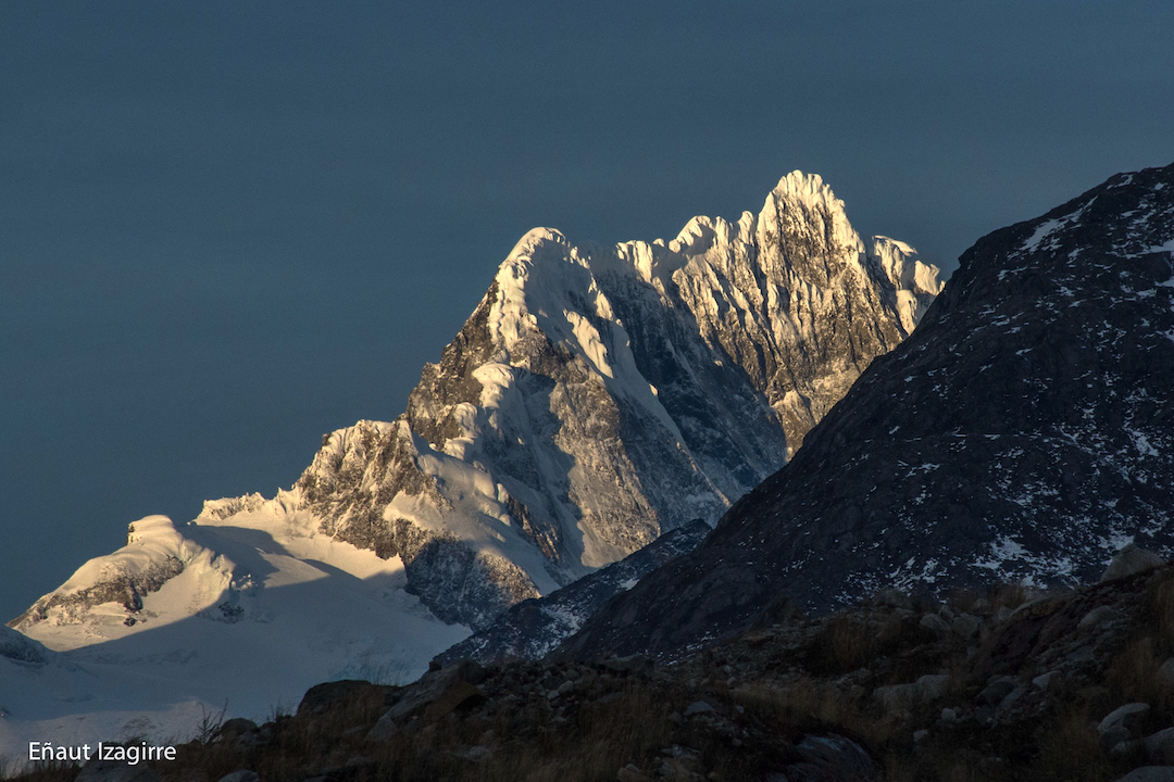
Roncagli had been described by David Hillebrandt as one of the last great unclimbed peaks in the Southern Hemisphere. It was first attempted by a New Zealand expedition in 1971. Subsequently, in 1990, Hillebrandt and his team made a remarkable ascent of the north pillar of Roncagli, reaching the west summit (about 100m lower than the main summit). Simon Yates and partner made an attempt at the northwest edge. Yates tried again in 2013 on the south side, where they were stopped by a huge crevasse. In 2022, Roncagli was still one of the highest unclimbed summits in the Cordillera Darwin.
 After a day of scouting, we received a forecast from Chilean geographer and climber Camilo Rada that promised a 20-hour window, lasting through March 23. The entire group set out together on March 22, reaching 1,300m at the base of the Francés/Holanda Glacier. The next day, Jony and Ibai left at dawn to climb while the rest of the team conducted scientific fieldwork on the Roncagli Glacier.
After crossing the Francés Glacier, the base of Monte Bove, and the pass below Aleta de Tiburón, the climbers reached the south slope of Monte Roncagli. They left bivouac supplies at the base to ascend as quickly as possible.
Using satellite imagery, the expedition had already identified a logical line up a glacial slope that, although it passed near two areas of seracs, promised a quick ascent. After quickly crossing the serac area, climbing some ice ramps, and encountering no large crevasses, they realized Roncagli’s gates were open. The final ridge was a visual feast, with wind-sculpted features, snow fluting, and small ice mushrooms. They summited Monte Roncagli at 4:30 p.m. on March 23, having climbed the southeast face (600m, AI3 60°). On top, they performed an elevation survey with a high-precision differential GPS, measuring an elevation of 2,251m (54°50'54"S, 69°7'4"W). The two descended the same way they had climbed.
Back aboard the Kotik, we sailed west toward Bahía Alemania (close to the terminus of the Roncagli Glacier), where the team conducted scientific fieldwork over the next few days, and then continued into Fiordo Pía, anchoring in a small inlet to spend the night. There was limited time before a forecasted Antarctic front would stall over the Cordillera Darwin for at least a week. The idea was to climb Cerro Sara (2,072m, 54°41'39"S, 69°38'39"W), a beautiful mountain that crowns the dividing line of Fiordo Pía’s two arms, while also doing scientific fieldwork in the inner part of the fjord. Cerro Sara had been attempted twice, in 1990 and 2004, by German and New Zealand teams. The name Sara had been given by the first expedition after the Bob Dylan song “Sara.”
The next day, Jony and Ibai began approaching Cerro Sara, and at sunset they set up camp. That night, the stars filled the sky and there was no wind or clouds. The next day a snowstorm covered everything and visibility was limited. Fortunately, the wind was moderate and they were able to climb. The terrain was mixed with snow-covered rock and little ice. They reached the top at 1:30 p.m. on April 2, having climbed the southwest ridge (500m, M4/M5 85°). That same day, they headed back to sea level, rappelling, crossing glaciers, and descending forest, stream, and grass, all at astonishing inclines. Precipitation increased throughout the day, and by the time they arrived at the sailboat, it was snowing at sea level. It was the beginning of a four-day Antarctic storm.
 The final climbing objective was the south face of Monte Francés (54°53'32"S, 69°9'5"W), just south of Roncagli, for which Jony and Ibai had sketched out a plan a couple of weeks earlier. At that time, the face appeared to be composed of good granite snaked by thin ice lines, and we expected the ice to grow. This wall, too, had been a target of Simon Yates and Andy Parkin. On the morning of April 9, Igor took Jony and Ibai by Zodiac to the beach. They made their way along a small trail that led over beaver dams and through forests to Laguna Francés—this was the only “trail” we found in the Cordillera Darwin. After reaching the glacier, it became evident all the ice on the wall had collapsed.
The next day, April 10, Jony and Ibai started at 6 a.m., hoping to connect the right flank of the south face with the seracs of the southeast edge. They moved together up snow ramps, frozen waterfalls, and some mixed sections. Conditions were fine, but at the top they had to contend with the risk of big seracs along the southeast edge. Finally they reached the previously climbed southeast ridge. Because of poor visibility and light snowfall, they could not see the summit.
They continued over glacial terrain, more seracs, mushrooms, and wind formations until, finally, a few meters from the summit, the clouds cleared to reveal a maze of islands, mountains, glaciers, and peaks covered with Patagonian merengue. With their 400m variant (WI4 80°) to the southeast ridge (800m vertical gain in all), they completed the sixth documented ascent of Monte Francés (2,261m), the most visited mountain in the range. Upon arriving back to sea level, the climbers were joined by the rest of the team, who had finished their scientific work in the upper part of the Italia Glacier.
In the following days, the wind and snow returned to their usual pattern, and we prepared for the return trip to Puerto Williams. The team was pleased with what we had done, both in science and in the mountains. Of course, it was never our intention to conquer this landscape. In fact, we had allowed ourselves to be conquered by the remote, lost, and wild Patagonia that still exists in the Cordillera Darwin.
— Eñaut Izagirre and Ibai Rico, Spain
Editor's Note: Another trip report and many more photographs can be seen at photographer Andrew Opila's website.
Media Gallery