Turnweather Peak, Rainy Day Dream Away
Canada, Nunavut, Baffin Island, Auyuittuq National Park
 On July 3, Neil Chelton, Maria Parkes, and I flew from Ottawa to Pangnirtung to start a seven-week expedition up the Weasel River in Auyuittuq National Park. After checking in with the park visitor center and learning all about the polar bears, we hopped on local outfitter Peter Kilabuk’s boat from Pangnirtung, then rode 30km into the fjord. We were dropped off around 1km south of the Overlord Shelter, close to the high-tide line, with 300kg of food and gear. From here we hiked to a preliminary campsite 3km up the Weasel Valley, dragging three packrafts we jam-packed with all our belongings.
During the trip planning, we used photos and route information to scout out a feasible new route on the center of Turnweather Peak's north face. However, upon arrival at the base of Turnweather, the line looked loose and unappealing. On the northeast side of the mountain (at the far left of the north face), we found an aesthetic line that approached from a steep side glacier to the base of a vertical wall. This wall led to the east spur of the mountain then continued to the summit tower. It was an easy decision to attempt this line instead.
We shuttled food and equipment to the base of the route over the following nine days. Our initial hike up the Turnweather Glacier involved traversing several difficult and dangerous moraines, however we managed to find a much safer alternative route up a more stable moraine immediately to the south of the main river flow. The hike from our camp at Weasel Valley to our camp at the base of the side glacier was approximately 12km over varied moraine, dry glacier and boulder fields. The last 1.5km over flat glacier was very slushy in early July, and we opted to bring our dry suits up the glacier to make shuttling this section more enjoyable!
Once our food and equipment were all at the base, we climbed and fixed ropes up the initial steep glacier on ice up to 70°. We only had one ice screw and a V-thread hook, which made the process of climbing and hauling on ice interesting. Eventually, we managed to move all the gear up the glacier to a belay at the base of the rock.
After we climbed the first rock pitch of the route, a tricky A4, and fixed the rope, the forecast showed several days of bad weather, so we opted to hike down to Weasel Valley to sit this out. After a few days the weather improved, we hiked back up to Turnweather and ascended our fixed lines and camped on portaledges at the start of the rock pitch. We climbed pitch two and hauled to this belay the following day.
For the next 18 days, we climbed capsule style, with camps at belays five, eight, ten and 15. The weather was consistently poor throughout our climb, with rain at some point every day. This slowed our ascent considerably. Despite the poor weather, we still managed to climb every day except for one, some days just fixing a short pitch.
Most pitches were aided and followed obvious crack systems and weaknesses. The rock was generally good, although the removal or avoidance of many detached blocks was necessary. The route stayed on a series of left-trending diagonal weaknesses, and we found no evidence of previous ascents in the first 15 pitches.
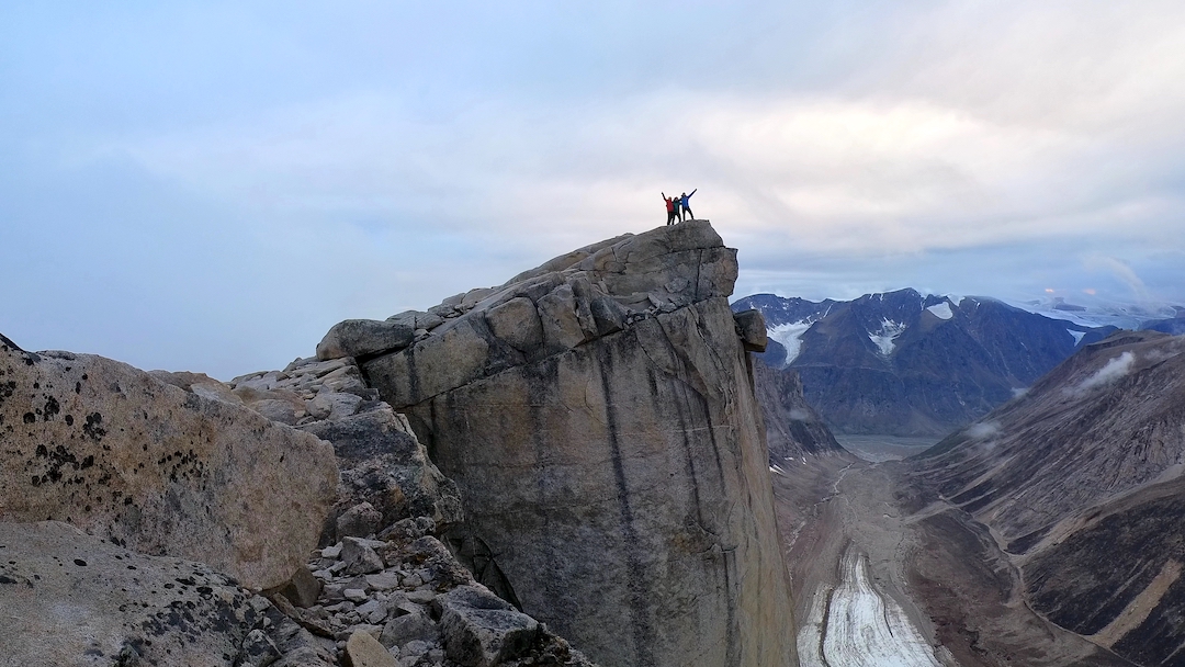
After 15 pitches we reached the lower-angle east ridge of the mountain. We ascended 100m of 4th class ridge to the base of the summit tower and then fixed three ropes straight down a blank wall to our previous camp (belay ten), so we could haul directly to the ridge.
At the base of the summit tower, we found two sets of bolts: one very old and the other much newer. [The origin of these bolts is not known but may have been left during the descent from one of the routes on Turnweather’s north face. The complete east ridge of Turnweather, the upper part of which was followed by the 2022 team after exiting the northeast face, has been climbed at least twice, by Clark Gerhardt and Craig McKibben in 1976 (5.8 A1) and by Delano Lavigne and Joshua Lavigne in 2012. The latter pair free climbed their line on the summit tower at 5.12. See AAJs 1977 and 2014.] We climbed four pitches on the summit tower, finding excellent golden granite, and then hiked to the top. We rappelled using the newer bolts the previous party installed. Once back on the ridge, we took a full day to rappel our route back to the glacier.
After hiking multiple loads out of the valley and back to our first camp, we spent a few days exploring further up the Weasel Valley. From our first camp at Weasel Valley, we packrafted for three days back to Pangnirtung, a distance of around 30km. We paddled for up to five hours each morning before the southerly headwinds picked up making the progress very difficult. The large tidal range in the fjord (up to seven meters) meant that we had to use discretion when picking camping spots so that we were not cut off by large tidal mudflats. We spent one night at Pangnirtung before catching our flights back to Ottawa on the 20th of August and then continued on to Vancouver.
— Owen Lee, New Zealand
Media Gallery