Inglefield Mountains, Exploration and Ivory Gull Research
Canada, Nunavut, Ellesmere Island, Prince of Wales Icefield

The Inglefield Mountains of southeast Ellesmere Island, north of Makinson Inlet, had been on my mind ever since I first saw them from the Manson Icefield in 2001. It took me until 2019 to finally visit, when Dave Critchley, Louise Jarry, and I chartered a Twin Otter ski plane from Kenn Borek Air out of Resolute Bay.
The 2.5-hour flight on May 14 took us over familiar terrain of the Sydkap Ice Cap (AAJ 2018), west of Grise Fiord, then on to the Inglefield Mountains: range after range of nunataks breaking out of the icefield. The landscape is huge—70km-long glaciers up to 25km wide, with meltwater stream canyons carving trenches in the ice 50km long. Circling our intended landing area west of Easter Island, the flight crew gave us bad news: The terrain was way too crevassed to attempt a landing. A backup spot 12km southwest was picked out (600m, 77°39.709'N, 78°42.252'W). Landing uphill in powder, with the plane’s skis penetrating 40cm deep, it didn’t take long to stop. We were 25km west-northwest of Cape Mouat.
We had come, primarily, to check for activity at ivory gull nesting sites last surveyed in 2009. The population of the gull in northern Canada has declined dramatically in the last several decades. Many nesting colony sites farther south, in the Manson Icefield, had already been abandoned by 2009. The first seven nesting sites we had planned to survey were now too far away from our landing site, so we began skiing northwest, heading to other nunataks occupied by gulls in 2009. Our path was repeatedly blocked by multiyear meltwater channels the size of canyons. It would not have been technically difficult to cross them, but unloading our 70kg pulk sleds, and lowering and raising everything each time, would have been far too time-consuming. Instead, we used our drone to scout for easy crossing points, savings hours each time.

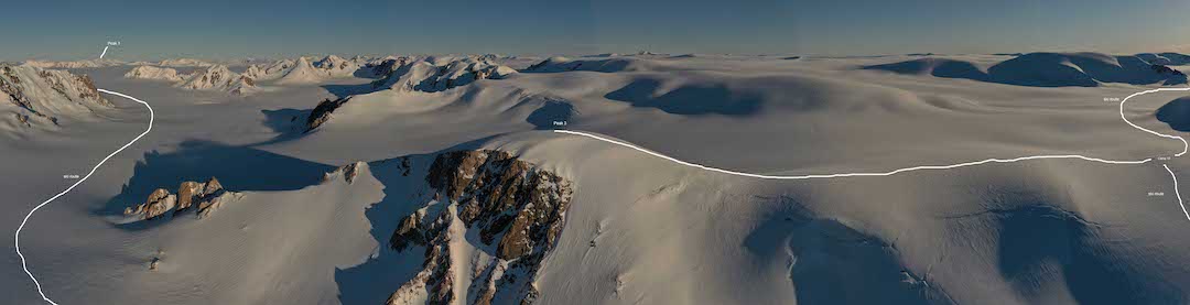
Four days into the tour, we stopped to ski up Peak 1 (1,450m, 77°47.669'N, 79°14.991'W) by its northwest ridge. Returning to camp early, we packed and descended to the Wykeham Glacier. Fifty kilometers long, the Wykeham is one of two substantial glaciers flowing into Talbot Inlet, producing thousands of icebergs. Until this point, crevasses had been few and far between and we had no problem skiing across them. On the Wykeham the situation changed. Crevasses were ubiquitous, and a roped-up crevasse fall by Dave that sucked his pulk in behind him was a reality check: As a three-person team with heavy pulks, we truly were in tiger country.
Every evening thereafter, weather permitting, we would launch a drone flight to scout the next day’s potential route. After crossing a low glacial divide into the head of the south branch of the Trinity Glacier, the other iceberg generator discharging into Talbot Inlet, it was obvious the crevasse situation would only be getting worse. We had checked four nest sites and found zero gull activity. The next sites, only two days away by direct ski travel, were blocked by hundreds of obvious sagging crevasses, and there was no way we could reach these nests. The only option was a one-week detour up and across a portion of the main Prince of Wales Icefield.
Ski ascents of Peak 2 (1,450m, 78°3.948'N, 80°1.516'W) and Peak 3 (1,410m, 78°2.722'N, 80°4.599'W) allowed us to climb high enough to see eastward to Greenland. At over 1,000m of elevation, the crevasse situation improved, but the possibility of a crevasse encounter in a whiteout still gave us an uncomfortable feeling. We made one more ski ascent, climbing Peak 4 (1,580m, 78°9.539'N, 79°25.301'W) from camp 14, before the weather—which until then had been perfect—changed for the worse. During three days in camp playing crib, 25cm of fresh snow buried all sign of the previous sagging bridges. Retreat back west to the flat icecap was necessary in order to find a landing area for the ski plane. An InReach forecast predicted June 6 would be the only clear day for the next five to seven. We had to take that day for a pickup or risk missing our scheduled commercial flights south.
The Twin Otter circled a couple times and then descended into the glacial basin to our north out of sight. Silence followed. After what seemed way too long a time, we heard the engines revving, then silence, followed by more revving. Just as we were about to launch a drone to investigate, a shark fin appeared from down slope. The tail rudder materialized as the plane climbed up the glacier, plowing through deep snow. They had landed on the closest sunlit patch of glacier and had been taxiing many kilometers on their skis, weaving around crevasses, to make their way uphill to our camp. Simply amazing.
We would like to acknowledge Arc’teryx, Campers Village, Canada Goose, DJI, Darren Vonk, Idea Wild, MEC, MultiRotorHeli, NAIT, PGYTECH, PolarPro, Polar Supplies, Sea to Summit, and Track ’n Trail—all of whom provided financial support, equipment, discounts, or technical advice.
– Greg Horne, Canada
Media Gallery