Two-Headed Massif, North Summit; Lal Sirang Kateth from the Northwest
Pakistan, Karakoram, Ghujerab Mountains, Khunjerab Subgroup

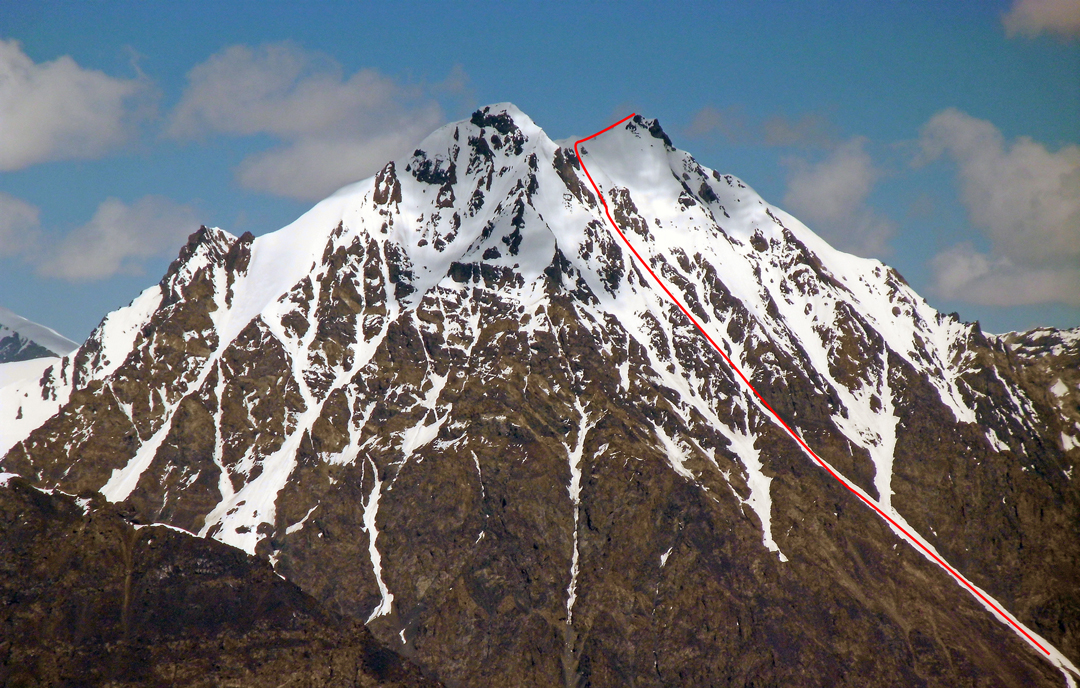
The Two-Headed Massif lies to the east of Yawash Sar and northwest of the North Ghidims Glacier. When developing a sketch map of the Ghidims Valley, I bestowed the name Two-Headed Massif on a twin-summited peak almost entirely surrounded by glacier-filled valleys. The Chinese-Pakistani topographic border map defines the south top as 5,929m. I calculated the north top was around 5,900m. In 2014, a Polish-Italian expedition with the Pakistani guide Karim Hayat climbed halfway up a couloir leading to the summit ridge but retreated in bad weather.
A second attempt took place in May 2018. This was a Polish Alpine Club expedition organized to celebrate the 100th anniversary of Poland regaining its independence. The team members were Tomasz Hełka, Wiktor Jurasz, Paweł Kułaga, Bogusław Magrel, Anna Migdał, Jan Pecka, Dawid Plewczyński, Monika Szławieniec-Reczuch, and Sławomir Wiktor, along with Karim Hayat and Rahmet Ullah Baig from Shimshal.
This team established base camp on May 26 at a place called Yakya (a.k.a. Dada Hakal Camp, 4,400m), and an advanced base on the North Ghidims Glacier at 4,900m. From there the team climbed Peak 5,531m (map height, 36°43'34.64"N, 75°30'40.86"E), lying on the Chinese border, and named it Polish Massif, measuring its height to be 5,360m.
On the 31st, Baig, Hayat, Hełka, Jurasz, Magrel, Plewczyński, Szławieniec-Reczuch, and Wiktor climbed to the north summit (36°43'20.25"N, 75°29'23.75"E) of Two-Headed Massif. They followed the southeast couloir toward the gap between the two summits, then up the short southwest ridge to the top (PD+). This was the route attempted by the 2014 expedition. Once on top, they established that the south peak was higher. They also said both peaks are around 5,700m; however, it is very unlikely for the carefully surveyed China-Pakistan map at 1:50,000 to have a 200m error, and as with their assessment of Polish Massif, it seems the Polish team under-read the altitude.
On June 3 they left the area to head back to Shimshal. On the 5th, while in the vicinity of Boesum Pass, Baig, Hełka, Jurasz, Kułaga, Magrel, Pecka, Plewczyński, Szławieniec-Reczuch, and Wiktor made the first ascent of Lal Sirang Kateth (5,680m, PD+) as a nine-member team. This top lies along the ridge to the south of Boe Sar (first climbed in 2005 by Abdullah Bai and Francois Carrel; see AAJ 2006). The team climbed the west-northwest ridge toward the summit of Boe Sar, then slanted right to hit the north ridge of Lal Sirang Kateth, which they followed to the top. This summit is to the north of Peak 5,683m, climbed by a 2017 British expedition (see AAJ 2018).
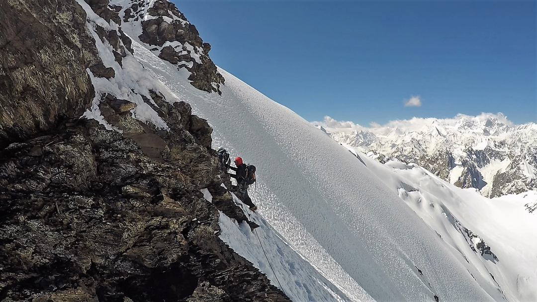
Paweł Kułaga adds some notes on the ascent of Lal Sirang Kateth: From a base camp at 4,800m by a frozen lake north of Boisum Pass, we began climbing up the northwest flank of the mountain at 2 a.m., and six hours later reached the north ridge at around 5,500m. From here to the top was the most serious part of the ascent, with cornices and plenty of exposure. We traversed below the north summit into the gap beyond, from where we all climbed to the north summit. Magrel also went to the south top—both seemed the same height, which we measured at 5,680m. We descended the west slope toward Boisum Pass and regained base camp at 3 p.m., the last part through knee-deep wet snow.
– Jerzy Wala, Poland, translated by Monika Hartman, supplied by Janusz Majer
Media Gallery