

Pik Ushat, Historical Corrections
Kyrgyzstan, Tien Shan, Ushat-too
 In AAJ 2019 reported the presumed first ascent of Pik Ushat by an Australian expedition. However, this was not the first ascent, nor even the second, as noted in the following report from a two-man team that visited the area in 2002.
After an almost six-week-long cartographic expedition to the region of the South Inylchek Glacier (see summary in AAJ 2003), we had a few days to spare before leaving for home. Paul Sass and I took this opportunity to make a quick reconnaissance to the Ushat-too, the small range of peaks just a few kilometers south of Inylchek village. On September 3, 2002, we used horses to move south from Inylchek on a dirt road, then cross a bridge over the Kayindy (Kaindy) River. We camped where the Sarydjaz River enters a canyon, then next day continued alone, along the east bank of the valley, until we turned left into the Ushat (Taldybulak) Valley.
The lower Ushat is idyllic, with flowers and birch trees. A little path led us up the valley, and when it turned right in the direction of the Ushat Pass (a.k.a. Kumar Pass, 3,775m) we continued straight ahead and camped on moraine. The next day we reached the heart of the horseshoe-shaped range. There were beautiful views to the south, where Pik 5,140m caught our attention.
We had no information about prior ascents in the range, except for Pik Ushat (5,142m), the highest summit, which local mountain guides told us had been climbed from the north. However, they had no clear details as to when or by whom. As we had only three days available, Paul and I felt Pik 5,140m was too far away, so instead concentrated on the stunning pyramid of Pik Ushat. We headed east across the lower slopes and halfway up the mountain reached a campsite on a short rocky ridge. After a cold night we crossed a snow plateau to reach the icy headwall, then climbed three pitches (50–60°) to gain the crest of the splendid, sharp, and sometimes corniced west ridge. It took us almost an hour to traverse the few hundred meters to the highest point, which we reached at around 10 a.m., and from there enjoyed views over the whole Ushat range. Another interesting and probably unclimbed peak (4,950m) was visible to the east.
Then, to our surprise, we saw fresh tracks in the snow coming up the east ridge—obviously there was a recent route from the opposite side as well. Even more surprising, the summit sported a framed picture, showing the portrait of a man. What had at first seemed a lonely and isolated peak, turned out to have been climbed just a day or two previously. Therefore, to our knowledge there were at least two ascents prior to ours, up the north and east sides, and according to local information our route up the north face was most likely the same as one climbed previously.
We reversed our route to the valley, which we reached at 2 p.m. The excellent weather of the last few days was turning, and we were in a rush to return to Maida Adyr. That same day we crossed a pass north into the Kayindy Valley, spent a night with hospitable shepherds, and the following morning, September 7, were accompanied by locals and horses to a 3,821m pass in the Maida Adyr Range. We crossed this and continued down alone to rejoin the rest of our expedition at Maida Adyr.
– Markus Kautz, Germany
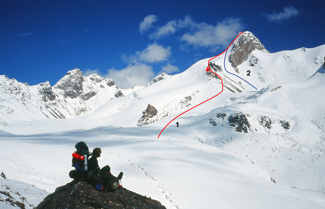 |
| Markus Kautz surveys Pik Ushat from the west. (1) The 2002 Kautz-Sass ascent and camp on the rocky ridge. (2) 2018 Australian ascent. |
Media Gallery


