

Solo in the Kanti Himal: The First Ascents of Three 6,000-meter Peaks
Nepal, Western Nepal, Kanti Himal
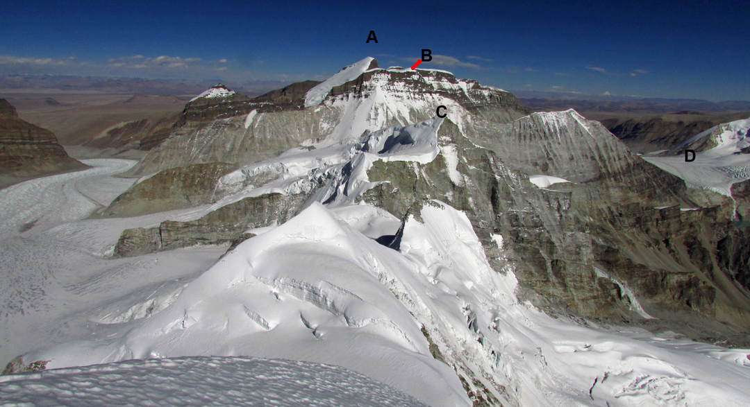
Looking east-northeast from Churau to (A) Rongla Kangri, (B) Rongla south top, (C) Peak 6,265m, and (D) Koji La. The long glacier on the left flows to the Tibetan Plateau. |
A CONFLUENCE of circumstances led to my three partners for a mini-expedition in November canceling their plans. This left me in Kathmandu, fully acclimatized after a Takphu expedition, fully alone, and with four weeks to kill. This hadn't come as a complete surprise, and I had already carried out preemptive Google Earthing that, even with the need for soloing margins of safety, had revealed Rongla Kangri (6,647m) as a worthwhile target. So, after a few days to round up paperwork, a few hours to work out transport, and a few minutes to pack what I could feasibly carry, on October 31 I headed on my way.
This started with two and a half days on public buses to Gamgadhi. I used the bus mainly so I could bring gas canisters with me, but the low cost, local color, priceless experiences teetering around cliff edges, and, in the end, the lack of a functioning airstrip at Rara Lake, all made it seem, in retrospect, like a decent plan.
Given my agenda and the local English-language skills, it didn't seem like a good idea to complicate matters by retaining a porter, and my pack leaving Gamgadhi weighed about 25kg. I set a conservative pace up the pretty canyon of the Mugu Karnali. On the third day, the valley turned north and, as I passed through Mugu village, opened into high pastures lining the river. I found a grazing trail heading east through a cedar forest up the Koji Khola and, at the end of day four, arrived at the 5,000m lake directly below the Koji La (5,495m on HMG-Finn map but measured at around 5,470m, due to glacial melt). Despite this pass being an entirely off-limits crossing into Tibet, it sported quite a well-marked trail as far as the flat, icy glacier.
On day five I inspected the Rongla cirque, which from a distance offered no options for reaching the cols on either side of the summit. On day six I set off underneath the southwest face, with intent to cross the west ridge where it merged into the glacier, hoping that a route could be followed up the northwest face. This plan folded when the west ridge turned out to be a vertical choss band, so I beat a retreat to a lower glacier fork and climbed the next summit west from Rongla. A glacier hike to 5,800m, 400m of 45° southeast-facing névé, and 500m along the northeast ridge brought me to a summit I measured at 6,265m. The wind was moderate and the sky cloudless, affording spectacular views across both Tibet and Nepal. I could see that the northwest face of Rongla, although low-angle, had a rocky finish, and thus the east side was going to need a more detailed inspection after all.
 With the weather remaining excellent, I set off next morning, planning to summit Rongla Kangri that day. I met the sunrise on the Koji La and continued northwest toward the summit. High-altitude cloud streamers started blowing by, but instead of thickening to spoil the day, they evaporated within two hours. The glacier flattened out and met the cliffs at 5,800m, but there was an option on the far left side of the cirque, next to the southeast ridge, to climb 45° névé all the way to the south top of Rongla Kangri (a.k.a. Kanti East), a border “peak” given the height 6,516m. From there I dropped about 75m down a low-angle ridge and then hiked northeast up snow slopes to the true summit of Rongla Kangri (6,647m), arriving at 1:45 p.m. I was treated to views from Gurla Mandhata to Annapurna, far out over the red plateau lands of Tibet, and over the jagged white carpet of Nepal. On my eighth day out, the weather turned cloudy and cold, and it was a mandatory rest day anyway. For the ninth day I had harbored notions of climbing the southern wall of the Koji Khola to exit onto the flat glacier near Kaqur Kangri (6,859m; climbed in 2002 from the east by Japanese), and then summit a peak close to it. However, by now the difference between south-facing ice glaciers and north-facing, snow-covered ones had not escaped my attention, and I had no desire to push my soloing luck any further. Instead, I climbed just high enough to reconnoiter Churau (6,419m), the somewhat dramatic, double-peaked mountain to the west of Peak 6,265m. I then moved my camp an hour down-valley to be ready for another quick start.
Sunrise the next morning found me well up my intended approach, but a hidden glacier trench forced me to change plans, as I could no longer reach the direct south face safely. Instead, I headed to the east ridge, which I reached with only a little heavy trail-breaking, and before the south-facing snow became too soft. I followed the crest over a subsummit to a final 45° snow climb that led directly to the top of Churau. The views once again stretched northwest across the many unclimbed border peaks and south to the Dhaulagiri massif. From this angle, the peaks east of Kaqur were more in evidence, reinforcing earlier thoughts I’d had about giving them a closer look.
The next day turned cloudy, with passing snow showers on a strong wind. My welcome in the Koji Khola had expired and I walked out to Mugu. I spent two days exploring the access to the Upper Dolpo via the Chyargo La (5,150m), and getting that closer look, before returning to Gamgadhi at the end of my 15th day out. Another scenic bus tour of 55 unforgettable hours delivered me back to Kathmandu.
– Bruce Normand, Switzerland
Media Gallery


