No Stereoscopic Vision: Off the Map on the Erasmo Icefield, a Forgotten Corner of Patagonia
Chile, Aysén Region
 In the winter of 2006, during a plane flight to San Rafael Lagoon to begin the first north-south winter crossing of the Northern Patagonian Icefield, I saw through the window a huge mass of ice surrounded by impenetrable forests and a glacier that almost touched the ocean. It was the Erasmo Icefield (a.k.a. Erasmus Icefield, approximately 46°9'S, 73°8'W)—an ice mass of about 165 square kilometers that is just 7km away from the sea; however, because of its geography, surrounding mountains, and forests, it cannot be seen from the sea. This has helped keep it hidden to visitors.
From the west, you can access the Erasmo by sea. From the Cupquelan Fjord, one can access Erasmo Bay and, from there, follow the Sorpresa River and then a small tributary, El Pájaro, past a series of three lakes, across a mountain pass, and end up at the main tongue of the Erasmo Glacier, the main icefall flowing down from the larger icefield.
However, what in 2006 was a glacier enclosed by rock walls is today a large lake surrounded by rock walls, with the glacier shrinking into these waters. For our first expedition, the definitive access would be via water, and we would have to carry packrafts to reach the icefield.
November 2017
Together with two Chilean friends, Tomas Torres and Juan Fco. Bustos, we left Santiago for three weeks to explore the access to Erasmo and maybe climb something there. On November 1, we took a speed boat ride to the end of the Cupquelan Fjord, and from there, over three days, we went up the valley of the Sorpresa River (meaning “Surprise”) and then followed the small and narrow but strong stream El Pájaro (“The Bird”). The weather was very nice, even warm.
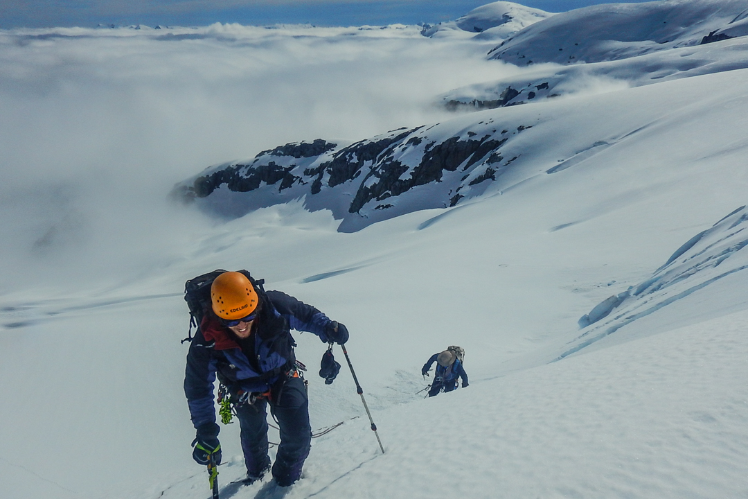
On the fourth day we reached the system of three small lakes, which we crossed using packrafts. Climbing over a mountain pass that we named Paso Rata, we arrived at the lake at the toe of the Erasmo Glacier—magical, and possibly one of the most spectacular, hidden places in Patagonia. We were the first to set foot there.

The next morning, we assembled our boats and donned dry suits because of the cold water, and we began to navigate between icebergs and granite walls in the white lake, colored so due to its heavy load of glacial sediments. We reached the other side and climbed onto the glacier, ascending its southern side. At the end of the day, we reached a beautiful small lake overlooking the glacier and Erasmo Lake; we christened it Laguna Canquenes.
Bad weather arrived that afternoon, and it rained for four days in a row, leaving us stranded at the small lake. Running out of time, we decided to head out with two days’ worth of food and equipment. We followed the valley to its end and accessed the plateau of the icefield by a small, lateral glacier, where we set up camp at 1,150m. That same afternoon we quickly went out to climb a nearby unnamed mountain, which we called Cerro Mirador del Erasmo. This was an easy climb on snow and rock, but it allowed us to see the glacial lakes of Erasmo on a somewhat stormy afternoon.
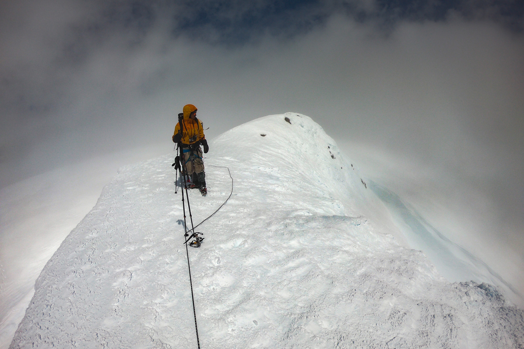
 On November 11 we left very early to reach the main summit of the glacier, a hill 3 km south of our camp and approximately 900m higher. We covered that distance by crossing snow slopes and some crevasses, but nothing difficult. However, clouds entered quickly from the Pacific, threatening to leave us in a whiteout and unable to find the summit. Neither GPS nor cartography were of any help because the area is just a white blob on the map labeled “no stereoscopic vision.” At the end, we barely beat the clouds in reaching the summit of what would now be Mt. Teresa (1,947m). We descended with equanimity, surrounded by the storm and just following our footsteps.
Short of food and time, we had to start our return. We chose to go more directly by the south side of the Erasmo Glacier until we reached the lakes. Then we navigated the rivers on our packrafts, covering ground very quickly until the rain came. For the rest of the days, it rained nonstop. The rain would have been nothing more than an inconvenience had it not been for the passage of the Los Pájaros, which contains a very narrow sector, 3 km long, that was too dangerous to raft and required several crossings of the river on foot. To be precise, there were 22 river crossings.
With rain the river grew, and the crossings became very difficult, with several of them requiring the use of roped belays. After five days of fighting with the river, we finally reached the sea. The next day we were picked up by the same speed boat and returned to civilization after 90km of new ground explored and 19 days of adventures.
November 2018
Although Patagonia is associated with difficult mountains, technical climbs, and a complex meteorology, there is still room for classical mountaineering and exploration. These journeys seek to solve the simple issues of reaching the mountain and overcoming what difficulties the mountain will offer without the help of previous reports or experiences. After our 2017 journey, we felt that Erasmo still offered a lot to explore.
Again, with Tomas Torres, and now Alonso Fuentes, we decided to explore the northeast side of the Erasmo Icefield. We wanted to access another plateau that we did not reach on the previous year, so we decided to explore the upper valley of the Teresa River.
We flew to Coyhaique and then began our journey toward the icefield from the south-southwest by the Exploradores Valley, reaching the Teresa River where it meets with the large Exploradores River. Going up the Teresa Valley involves multiple river crossings. These were initially impossible due to the intense rain of the previous days—and it was still pouring—so we waited four days to go up the Teresa.

We traveled with a local muleteer and carried our loads on horses for 22 km. The upper valley of the Teresa ends in a wide area of glaciers and rock walls of very poor quality. There was only one potential access point through a large and steep talus ridge, and then across a snow ridge, that might allow us to reach the icefield above. However, we still did not know if the icefield would be reachable this way. Finally, after two days carrying loads, we reached the ice plateau of Erasmo on the afternoon of November 27. This is a large plain, 5km wide, which to the east leads to the valley of the Murta River and, to the west, toward the Pacific Ocean.
The next day, we attempted to reach a hill we could see to the north, possibly the highest in the area. The characteristic bad weather, with low clouds and strong wind increasing rapidly though the morning, prevented us from going very far, and we returned to our camp on the ice. That same afternoon, it cleared up a bit and we set off to climb a small summit near the camp, now called Cerro Don Bigote (1,726m, 46°9'3.28" S, 73°8'.82" W). From the summit, we saw Mt. Teresa, the peak we had ascended the previous year, and the massif of San Valentín to the south, also an old acquaintance. At night, the bad weather reached camp and stayed with us for two days.
On November 30, we looked for the main peak of the Erasmo Icefield. In four hours, we crossed the plateau to the north and started to follow a series of small peaks. We were surrounded by clouds, barely orienting ourselves with the GPS and by brief glimpses through the fog. A long slope of ice took us to a small terrace with a very curious rock formation surrounded by ice. Following this, we finally accessed the summit ridge and then the summit of this true peak, which we named Cerro Don Antonio (1,803m, 46°6'33.36" S, 73°6'3.87" W) It was a classic, small, and very airy place. On one side was the valley of the Murta River; on the other, the valley of the Engaño River, and, far away, I thought I could see the sea.
After this ascent, there was, indeed, no other significant summit to reach in the icefield. However, close by, to the northeast, is a peak the old maps call “Erasmo Mountain” (a.k.a. Cerro Erasmo). It is not actually within the Erasmo Icefield, but it may be about 1,900m. It appears very difficult to reach this peak. A different approach would be necessary—a very long one—likely up the Murta River, and there would be several lake crossings.
In the final days, the weather did not help us much. There was no time to visit this “Erasmo Mountain,” and we started back. Our descent was made by following the Teresa River in packrafts, enjoying every row and turn of the river.
These two explorations to a lost place—but, at the same time, very close in Patagonia—exemplify how there are still places for a simpler mountaineering, one that leaves room to enjoy every moment in the mountains as if they were the first.
– Pablo Besser, Chile
Media Gallery

![[Clockwise from top left] Chain of lakes west of the icefield, seen from the Paso Rata; fording the upper Río el Pájaro in heavy rain; Cerro Teresa (1,947m) from Erasmo Lake; and Pablo Besser crossing the Pájaro.](https://aac-publications.s3.amazonaws.com/articles/aaj-13201215032-1560800664.png)
![[Clockwise from top] Cerro Bigote, near the high camp of the 2018 expedition; unclimbed “Cerro Erasmo” (ca 1,900m), located in a very remote setting northeast of the icefield; Chilean explorer Pablo Besser during the 2018 expedition.](https://aac-publications.s3.amazonaws.com/articles/aaj-13201215032-1560800740.png)