

Cerro Almirante Nieto, South Face, Linea de Libertad
Chile, Southern Patagonia, Torres del Paine National Park
WORKING AS a trekking guide in Torres del Paine for a few years, it was hard to ignore this incredible line on the south side of Cerro Almirante Nieto. I tried the route alone a couple of times, in different times of the year, without success. I realized that to succeed I needed to enjoy this route with someone else. Soon after, I meet Felipe Bishara, who had recently become the first Chilean to climb Denali’s Cassin Ridge. Just one week after telling him of my project, we got the perfect window in mid-August, right at the end of the austral winter.

[Editor’s note: Cerro Almirante Nieto (a.k.a. Paine Chico) is located on the eastern side of Torres del Paine National Park. It is a large, complex mountain with an east and west summit, both approximately 2,600m—sources differ on which peak is higher. The normal route (AD), first ascended in 1937, is accessed from Camp Torres, below the three Torres del Paine, and climbs the northeast side to the east summit. The steep west side of the massif has seen a number of successful and unsuccessful climbs over the years; search the AAJ online for reports. The route described here ascended the south side of the east peak.]
 We traveled to the park from Punta Arenas in Lusi, a 1997 Toyota HiAce. Once parked, we hiked as fast as we could for about three hours to reach the beginning of our route on the south face. We bivouacked on a small terrace for six hours, sharing one sleeping bag—cozy!
On August 12 we started the real climbing around 2 a.m. The initial canaleta (which beings at around 1,300m height) was filled with alpine ice and some snow (75–90°). After 10 hours and 10 pitches of climbing on this ramp (which faces south-southwest), we reached mid-height on the face around 11 a.m.; here we took a small rest on a ledge and analyzed the snow conditions. The wall above faces south-southeast and had a huge amount of snow on its slopes—it was quite intimidating. After some stability tests, we decided to go—after all, it was the only choice! Five pitches of really deep, unconsolidated snow and some simul-climbing brought us to the top of the face at around 2,000m. [ See a video of this part of the climb.]
Sadly for us, we had spent too much time on the wall and were still far from the summit; however, we had realized our main goal of opening a new route on the south face. After 18 hours of uninterrupted climbing, we began crossing a hanging glacier toward the east summit, on the southeast side (ca 2,300m). We spent the next five hours rounding the mountain, trying to connect with the normal route. In darkness, this was the most difficult part of our adventure.
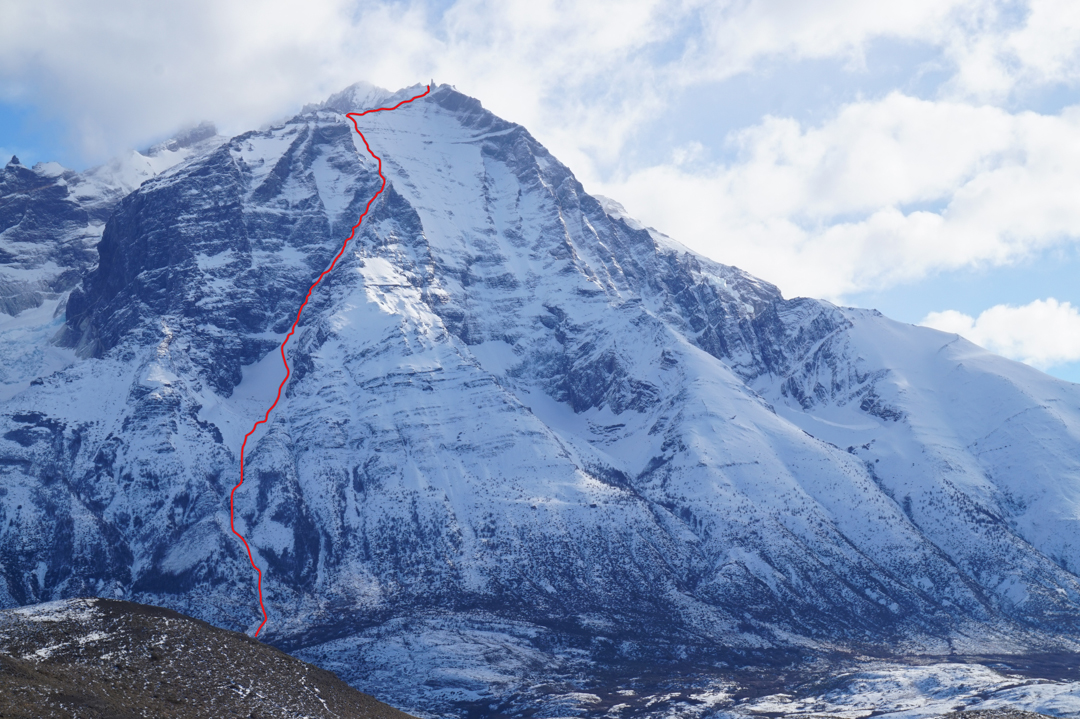
After 25 hours, we were low on food and water, and the wind was now blowing 80–110 kmh. When we finally reached the normal route at around 2,400m, we’d lost sensation in our fingers and toes. We made five 60m simul-rappels down the 300m gully on that route and then connected to the trail. We reached Camp Torres around 6 a.m. It was still dark, but we continued three more hours on a nice, smooth trail to reach Lusi again, ending our 31-hour “day.”
Our route, Linea de Libertad, is dedicated to the memory of Cristobal Bizzarri, a Chilean climber who passed away while climbing in Peru’s Cordillera Blanca.
– Christian Barra Muñoz, Chile
Media Gallery


