Trident, Northwest Face and Southwest Ridge (Not to Summit); Mitón, First Ascent by East Ridge
Peru, Cordillera Carabaya
In August, I led a 10-day traverse across the Cordillera Carabaya between the towns of Macusani (4,300m) and Ollachea (2,800m), including various side trips. We were an entirely self-supported group of four enthusiastic people: Giselle Field, Matthew Scott, Steve Yamamoto, (all USA), and myself. The weather was mostly poor, with nasty snowstorms occurring almost every day.
 |  |
On August 22, from a high camp on a narrow, snow-covered shelf at 5,000m, Giselle and Steve joined me for an attempt on Trident (5,490m), one of the most difficult major summits in the Allinccapac massif. All of our gear was caked in ice from a snowstorm the previous day, so we were unable to set off until 6 a.m., when the sun melted our gear into a usable state. We started at the toe of the kilometer-long valley glacier on the north side of Trident. We encountered large paw prints at 5,250m, which we took to be puma tracks—the tracks made a one-way path into a large crevasse.
 By noon, we reached the northwest-facing ice wall between the southwest and central summits of Trident. We climbed this via a narrow runnel on the far right side, which we called the Honeymoon Chute (AI3, 200m) on account of it being Giselle and my actual honeymoon. We moved quickly due to rockfall from the cliffs above. We gained the knife-edge summit ridge at 1 p.m. Moving northeast, two pitches of steep mixed climbing (M4) got us to what we’d thought would be the summit (5,570m GPS). However, we now realized the true summit stood several hundred meters farther along the ridge, on the other side of a deep notch. It appeared to be less than 30m higher than this lesser summit.
We proceeded along the wild ridgeline, climbing up and around terrifying gendarmes (5.9+ R). By 4 p.m. we had reached the notch (5,568m GPS); the summit stood less than 50m above us but was guarded by a plethora of obstacles. Feeling we’d pushed our luck, we made the decision to retreat by rappelling straight down the west face of the main peak as the sun dipped into the horizon.
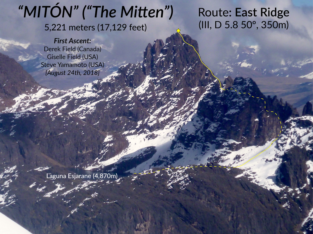
On the morning of August 24, all four of us prepared for a peak that had caught my eye several times in recent years: a conspicuous mitten-shaped rock tower crowning the western edge of the range. It is located less than a kilometer northeast of Cerro Esjarane, which appears to have a similar elevation despite posing no apparent challenge to the mountaineer.
At 2:30 a.m., we left our camp on the west shore of Laguna Siurococha (4,530m) and scrambled up an improbably steep canyon and tributary to the south shore of Laguna Esjarane (4,870m), the deep blue lake at the base of our objective. Matt stayed here while Steve, Giselle, and I started our ascent with the rising sun.We chose the east ridge for its aesthetic, direct line to the summit. Getting there proved tedious, but by 8:30 a.m. we had gained the base of the east ridge proper (5,080m). The weather was perfect for rock climbing and we soon fulfilled our desire for fun, moderate climbing on solid stone. The description for each pitch is mostly, “Follow the ridge—5.7, 50m.” The fifth pitch offered the crux: a steep dihedral (5.8) leading into a good crack system. Beyond, a short final lead gained the top. The three of us reached the summit (5,221m GPS) at 12:30 p.m. We decided to name the peak Mitón. Our route up the east ridge, starting from Laguna Esjarane, is 350m, D 5.8 50°.

After soaking in the views, we descended the southwest buttress with three 60m rappels. While rappelling, four condors swooshed across the sky in incredibly close proximity. I have had many wonderful experiences with these majestic birds in the Andes, but nothing compared to this.
– Derek Field, Canada
Media Gallery