Rangston Gyathok, Southwest Ridge and West Face
India, East Karakoram, Kunzang Range

On July 22 our Estonian expedition summited Peak 6,801m GPS (6,751m on the Indian map; 34°37'06.3192"N, 78°04'38.7084"E), the highest unclimbed peak in the Kunzang Range. [The Kunzang Range is generally defined as the mountainous region north of the great bend in the Shyok River and south of the Shukpa Kunzang Range and Saser Kangri Group.] The ascent followed a complex approach to our high camp that required nearly two weeks. Although a road follows the Shyok River to the east of these mountains, it is generally off-limits to foreign visitors, necessitating a long approach from the south.
We left the village of Rongdo (3,200m) on July 9 with 20 horses (15 porters followed the next day) and began our 60km trek to the mountain, initially following the Rongdo Lungpa. After three days we established base camp at 5,387m (34°31'02.9136"N, 77°59'10.8348"E) beside the moraine of the Sagtopa Glacier.
On the 15th we crossed most of the Southeast Shukpa Kunzang Glacier, passing south and then west of 6,165-meter Mariushri, climbed in 2014 by a Canadian expedition (AAJ 2015). The following day we continued to a col leading over to the Phurdupka Glacier. The lowest point of this col is 5,981m, but it was heavily corniced on the northeastern side, so we moved up to 6,041m (34°34'18.1200"N, 78°01'53.9040"E) before making a rappel descent of 180m toward the Phurdupka Glacier. This was the first known crossing, and we named the passage Estonian Col. Nine porters made this crossing, the others having gone back when they got ill. (All route-finding and technical climbing on the expedition was carried out by the Estonian members of the team, and we all carried our share of the equipment.)
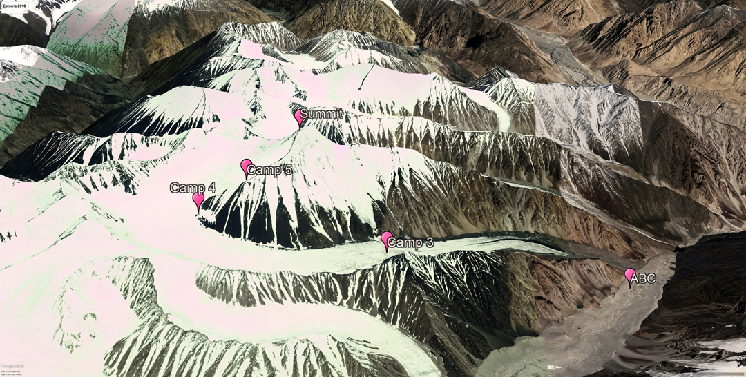
 On the 17th we descended the glacier to 4,878m (34°36'28.6668"N, 78°07'30.5508"E) and established our advanced base at the junction with North Phurdupka Glacier flowing east from our mountain.
After a rest day, we spent the next three days moving up the North Phurdupka Glacier, placing a high camp at 6,298m on the southwest ridge of Peak 6,801m. On the 22nd, leaving two porters and a Sherpa at high camp, Lauri Ehrenpreis, Priit Joosu, Meelis Luukas, Sven Oja, Lauri Stern, Priit Simson, and I, along with liaison officer Stanzing Norbu (a passionate climber with great knowledge of Ladakhi history) and Sherpa Pasang Temba Butia, continued up the ridge in cloudy weather with some snowfall. We moved west onto the face left of the ridge and then, via a 30m ice pitch (WI3), gained a couloir leading to the summit pyramid. Moving left through loose rock, we reached a short knife-edge snow arête, which we followed to the summit.
This peak has been identified by a variety of names: Kunchang Kangri (Google Earth); Phurdukpo Kangri I (Jurgalski); Unnamed Peak I Kungzang (Seyfferth); Mandaltang I (The Mountain Encyclopedia, Hartemann-Hauptman). We are more or less certain this mountain has no common name, nor had it been properly surveyed. We therefore decided to name it Rangston Gyathok, which means "100 years of independence" in Ladakhi and celebrates the 100th anniversary of the Republic of Estonia.
Our return journey to Rongdo was rather more dangerous than the approach, due to continually poor weather and snowfall. Snow bridges were softer, and Pasang, leading the way on the Southeast Shukpa Kunchang Glacier, took five falls into crevasses.
– Kristjan-Erik Suurväli, Estonia
Media Gallery