

Dhechyan Kang, First Official Ascent; Nagoru Far East, West Ridge
Nepal, Damodar and Peri Himals

Dhechyan Kang (6,019m, 29.036532°N, 84.249716°E) was opened for mountaineering in 2014 but has no recorded ascent. I found this rather surprising, as satellite images show it to be a broad, rounded hill without technical difficulties. The main challenge would be finding a suitable base camp with running water in an extremely arid environment.
After a flight to Jomsom and three hours in a jeep, Martin Thallmair (Germany) and I set out from Chusang on a six-day trek to the lakes called Damodar Kunda (5,000m), along with my good friend Lawang Tamang and Nepali staff. We arrived at the lake on May 1.
Based on exploration I’d done in 2013, we started our search for a base camp the next day but soon realized that during spring it is particularly difficult to find usable water. The narrow bottoms of river valleys often are covered with a thick layer of ice and frozen snow, and this simply does not melt during daytime. Our original plan had to be abandoned. We now decided to establish base camp close to the place marked on Paulo Grobel's map of this area (Himalayan MapHouse) as Bhrikuti Shail base camp. Fortunately, we found running water, and on the 3rd of May we moved there with the whole team.
Finding a convenient route to Thapulghocha La (5,328m), a wide and almost flat pass on the border between Nepal and China, was rather tricky, as there are several deep ravines that had to be circumvented or partially crossed. However, on the 4th we found and marked a suitable route with stones.On the 5th we left base camp at 5:50 a.m. We arrived at the Thapulghocha La at 7:10 a.m. and moved up the southern slopes of Dhechyan Khang, sticking to the Nepali side of the border. At 11:15 a.m., Martin, Lawang, Yokaci Tamang, and I reached the flat and unspectacular area around the summit, completing the official first ascent of Dhechyan Kang. However, a piece of metal wire on the Chinese side had already told us that we were not the first humans up there. Chinese military have apparently explored this mountain in the past, but who knows exactly how they got there.
Dhechyan Kang turned out to be a gentle high-altitude walk that any fit and acclimatized trekker could accomplish. But this summit is certainly worth a visit, as the view is simply stunning. To the north you can see the endless desert of the Tibetan highlands; to the south the snow and ice peaks of the Damodar Himal, with Annapurna II behind. Ratna Chuli rises prominently to the southeast, while Dhaulagiri dominates the view to the southwest. Under a cloudless sky and without any wind on top, we really enjoyed this unique panorama.
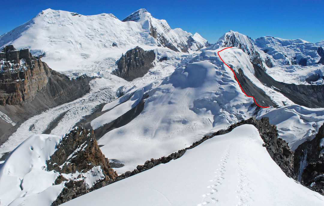
After our ascent of Dhechyan Kang, we headed to Saribung (6,328m) and climbed this peak, then crossed the Saribung La by the usual trekking route. On May 11 we established base camp at Nagoru Yak Kharka, as I had done in 2013 and 2016 (AAJ 2017). The goal this time was a summit I had named Nagoru Far East. In contrast to the three other Nagoru peaks (West, Central, and East), Nagoru Far East is barely visible from anywhere. I discovered it by chance in 2016 during a stroll from camp. My own photographs from the summit of Nagoru Central appeared to indicate an easy ascent. This impression, and our idea to reach the summit directly from Yak Kharka, proved to be complete misconceptions. While exploring during the afternoon of May 11, we realized we would need to find a new advanced base camp for the summit attempt.
 Next day we discovered a surprisingly lovely spot at 5,300m, two hours' walk from Yak Kharka. We moved there with all our staff on the 13th, and the same day climbed up to 5,700m, where we made a small cache of climbing gear. We had hoped to attempt the summit next day, but during the night it snowed. It was still snowing the following morning and had not let up by the evening. We were now close to failure, as the 15th had to be our last day in the area. What a relief to find the sky clear that morning.
Martin, Lawang, and I left at 6:10 a.m., arrived at our cache at 7:50 a.m., and then climbed a steep snow couloir to the saddle between Nagoru East and Far East. From there we turned east and followed a narrow rocky strip beside the glacier until the rock disappeared and we had to continue on the glacier itself. This soon led to a passage of blue ice at 45–50°, covered with 30cm of soft snow, which brought us to the start of the wide plateau leading to the summit. We found this section somewhat technically challenging and had to cut steps on the descent.
Once on the plateau, it was clear that the highest point was located at the eastern end, and the traverse to it passed impressive crevasses. This was the first time I saw my friend Lawang rather hesitant, but only for a moment. At 11:40 a.m., around 20 minutes after starting across the plateau, we were at the summit. Unfortunately, the weather had already turned cloudy and we were only able to catch a few glimpses of the surrounding mountain scenery. Nevertheless, we were happy with our first ascent, and we now know that Nagoru Far East is the most challenging of the four Nagoru peaks.
– Wolfgang Drexler, Austria
Media Gallery


