

Gen Glacier Basin: Pik 5,610m, North Face, Pik Patkhor, North Face Attempt
Tajikistan, Pamir, Rushan Range
Pete Dronkers and I (both U.S.) spent several weeks in August climbing in the central Rushan Range. We were drawn to the area by stable weather, unclimbed peaks, relatively simple access, and friends who had spent time recently in the range.
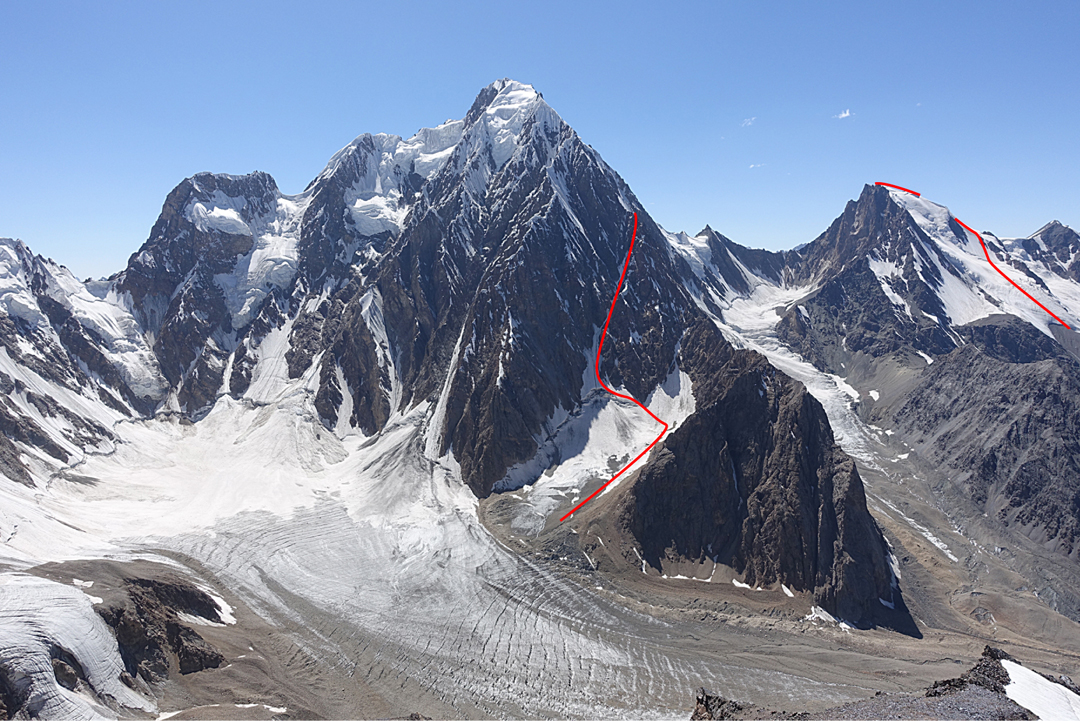
We used donkeys from the village of Basid in the Bartang Valley to carry supplies as far up the west branch of the Devlokh River as possible. From there we double-carried for another two days to set up base camp on the moraine of the Gen Glacier below the north face of Pik Patkhor (6,083 m). After extensive research, we are unaware of other climbing parties having visited the Gen basin. Patkhor is the highest peak in the Rushan Range, a somewhat overlooked subrange of the Pamirs with highly variable rock quality. [This area lies just northwest of the Shadzud Valley; see AAJ 2017: Report 1 and Report 2.] Patkhor was first climbed in 1946 from the south by a 12-member Soviet party that included Evgeny Abalakov (brother of the inventor of the Abalakov anchor). Its north and east faces rise vertically 1,600m above bergschrunds and 2,100 meters above the tongue of the Gen Glacier.
The outskirts of the Rushan Range boast some Sierra-quality granite, but most of what we found in the Gen basin was Pringles-like shale, the kind of rock that makes you an ice climber—or a beachgoer.
The high-pressure system that dominates the Pamirs most of the summer was as good as one could hope for. It rained for five minutes one day in camp. On two other days it snowed an inch or two. Temperatures at night above 5,000m were relatively warm, probably no cooler than -10° or -12°C. During one week we could count the total number of clouds on one hand.

After acclimatizing with various scrambles from base camp, we climbed a prominent unnamed summit (Pik 5,610m on the most recent Soviet map, but somewhat lower on our altimeter; 37°54'22.58"N, 72°10'24.01"E), the most appealing option in the Gen basin other than Patkhor itself. We reached the top via the north face (snow and ice up to 70°), using an advanced camp at which we spent two nights, climbing the route in a long day. The ice protection was adequate, and an exposed but short summit ridge brought us to the top. We have not found a record of this summit having been climbed previously. It afforded magnificent views into Afghanistan and the borders with Kyrgyzstan and China.
An attempt on the north face of Patkhor ended after two days because of our concerns about rock quality, rockfall, and the need to descend the same line of ascent via potentially dangerous rappels. It was a more circuitous alternative to the most obvious line on the north face, which was continuous ice and snow except for 50m of overhanging crumbly rock.
We also climbed a 300m rock line, Apricot Heaven (5.10+), partway up a tower in the lower Devlokh Valley. For parties willing to scout carefully and clean lines relatively solid, if somewhat decomposing, granite, this valley offers several miles of new route potential.
Rural Pamiri people are slowly emerging from an energy and environmental crisis precipitated by a civil war in the 1990s. Two years ago, Basid and neighboring villages finally obtained a stable source of electricity, following a hiatus of nearly 20 years, after the installation of a crowd-funded microturbine in a canal fed by the glacial torrent of the Devlokh River. When we visited, locals were busy building a new health clinic. Climbers to the area should consider contributing to such efforts.
Many thanks to Bo White and Odina Nurmamadov for their assistance.
Spencer Gray, AAC
Media Gallery


