

Lajo Dada (a.k.a. Langu Himal), Northern Glacier and West-Northwest Ridge
Nepal, Shingri Himal

On October 17 three young climbers from the Tomon Alpine Club—Norifumi Fukuda, a senior student at Waseda University, and two recent graduates, Kojuro Hagihara and me—made the first ascent of Lajo Dada (6,426m, 28°32'45.33"N, 85°3'12.18"E). This peak was opened by the Nepalese government in 2014 and lies west of the Tsum Valley, a little south of 6,065m Tabsar.
The Tsum Valley was only opened for trekking in 2008. Our only information about the peak was from Google Earth and a 1:50,000 map—this made the expedition quite adventurous, even for the approach.We set up base camp at 4,650m, above Mu Gompa (monastery) in the main valley. Establishing Camp 1 was a slow process, due to some illness and our need to acclimatize. We climbed a gully, then slanted left to reach the foot of the glacier (which we called Waseda Glacier). Twenty meters of 2nd-class rock led onto the glacier. At a flat spot with a small pool at 5,200m, we established Camp 1 on October 7.
We then spent three days setting up Camp 2 at 5,730m. Reaching that point was harder than we had imagined. On the first day we reached 5,400m, fixing 10m sections of WI3 and a sketchy à cheval snow bridge. The second day we extended the route to 5,650m. Above the previous day’s high point, we climbed a 10m icewall, then moved right along a huge serac until I could climb and fix a 25m snow/ice section of 85° (WI4). The terrain above was like a maze, but we eventually found a weak point in the ice walls, climbing a 10m section of ice and unstable sugar snow at WI4. On the third day we regained our high point, then walked up to establish Camp 2 before returning to base camp for a good rest.
We left for our summit attempt on the 15th, spending a night each at Camps 1 and 2 before leaving the latter at 3:20 a.m. on the 17th. As I was climbing a 40° ice slope covered by 25cm of snow, I was avalanched for 15m. Fortunately, everything was under control, and after switching to an alternative line up steeper, safer ice, we reached a plateau at 5,850m. We continued south up to a col on the Chhyosin Himal Ridge, which descends east-northeast toward the Tsum Valley, then followed the ridge southwest toward an unnamed, unclimbed peak of 6,200m. The ridge was mostly hard snow, with a steep drop to the south, but before reaching the summit there was a 3rd-class rock step that we simul-climbed.
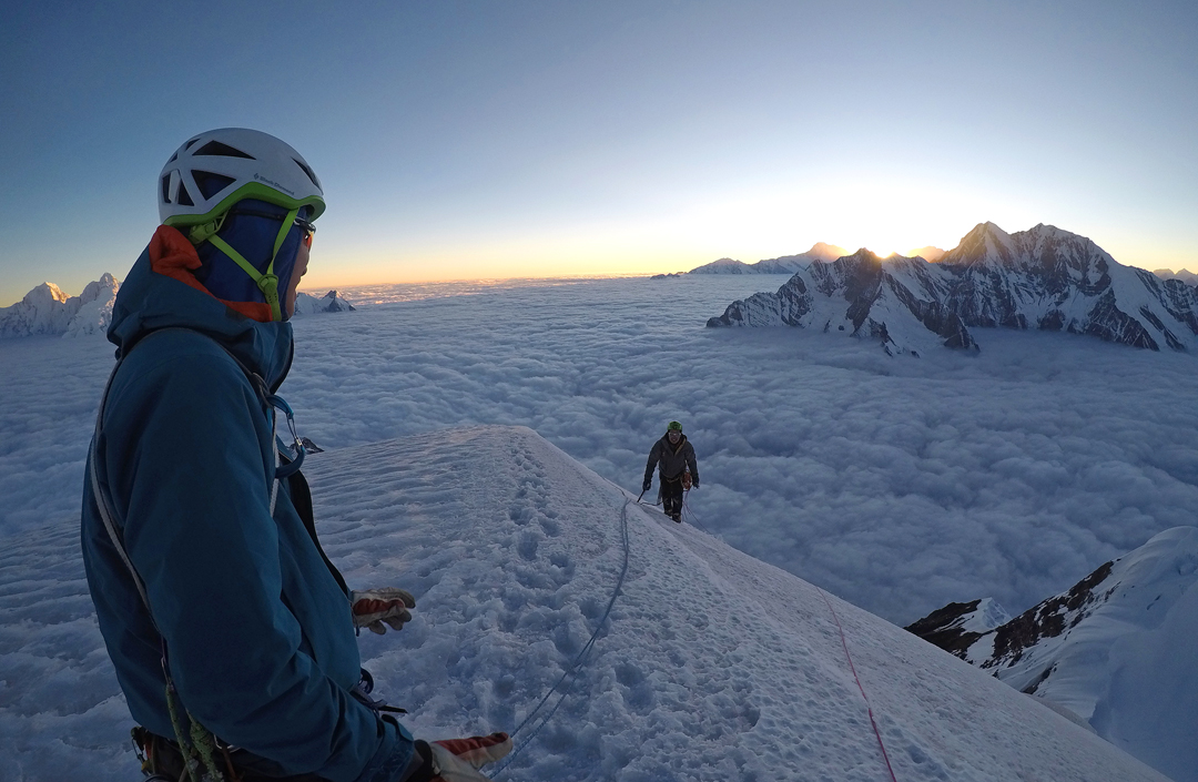
We stood on top Peak 6,200m, at the western end of the Chhyosin Ridge, at 9 a.m., and then descended south to the plateau in front of Lajo Dada. This proved hard work, as we had to break trail through 40cm of snow—really tough for bodies unacclimatized to 6,200m. It took four hours to reach the base of the west-northwest ridge of Lajo Dada, at around 6,170m.
This ridge was steeper than we had assumed, and to the right was a very steep drop of almost 2,000m. We also had anticipated it to be icy and had brought many screws but only six stakes or deadmen. With two of these at each belay, that only left two for protection. The first three pitches were generally snow and ice at 60° but steepening in parts to 75°. I led these carefully and the two others jumared. Kujoro led the fourth pitch: 50° but with masses of sugar snow. I then took over for the final two 50° pitches, which, although easier, still took much physical and mental energy because of the altitude and constant knowledge that falling was not an option. We reached the summit at 5:30 p.m., when it was beginning to get dark.
Without wasting time, we began rappelling the ridge, using snow anchors and V-threads. It was 9 p.m. when we reached the bottom of the ridge, and from there it took another eight hours to return to Camp 2, which we reached after a 26-hour day. Next day, with really sore bodies, we descended to base camp in 6.5 hours.
– Yudai Suzuki, Japan
Media Gallery


