

Peak 5, Southwest Pillar
Nepal, Mahalangur Himal, Barun Section
 Zsolt Torok and I flew to Lukla and acclimatized on the southeast ridge of Kyajo Ri (6,189m, Holby-Kear, 2005). On October 26 we flew to the Makalu-Barun region, where our objective was unclimbed Peak 5 (a.k.a. Saldim or Saldim Ri) on the border with Tibet. On arrival, we quickly realized that every map we had was wrong, and our summit was located in another valley. [Ascents of Peak 5 reported in the past, such as that of the 1989 British Makalu expedition, were actually on another peak farther east, with an altitude of 6,374m on HMG-Finn map, its southeast flanks overlooking the Lukuche or Saldim Valley.] With considerable effort, we relocated to a base camp in the Barun Valley, and on October 28, thanks to accurate maps from the 1980s received directly from Doug Scott, we finally reached the foot of the mountain.
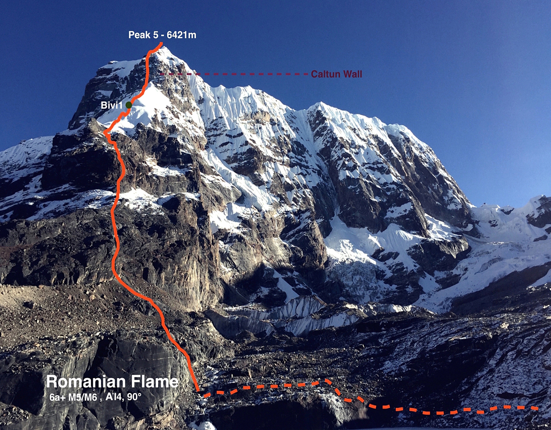
The weather was not the best, so we waited a day. Then, with no expectation of any change in conditions, we started climbing, alpine-style, on October 30, starting from an advanced base camp at the foot of the southwest pillar. We climbed the first wall directly, with passages of 6a/6a+ on solid granite. The climbing was really pleasant, but once we reached the small hanging glacier the weather changed and strong winds started to blow. This forced us to stop and camp, inside a crevasse at 5,800m. That night the temperature was very cold (-27°C).
The following morning we left early with the intention of reaching the summit. We started the upper wall, dubbed the Caltun Wall, after a peak at home, and met difficulties of M5/ M6 and WI4. After six pitches we got to the top of the headwall and found a somewhat easier ridge. This took us to the final ridge, which was a knife-edge and proved to be the most demanding part of the route, as we were unable to find any protection. Already exhausted by the wind and low temperatures, we took two or three hours to traverse the summit ridge, reaching the top a little after 2 p.m. According to our GPS, the altitude was 6,421m (6,388m on HMG-Finn map). On the upper route we found no trace of any previous passage. We spent only five minutes on top, due to high winds and poor visibility, and quickly started down the way we had come. After a 15-hour day we stopped at 5,900m for our second bivouac, and the following day made more than 20 rappels down our route to get off the mountain. We have named our route Romanian Flame (6a+ M5/6 AI4 90°).
– Vlad Capusan, Romania
Media Gallery


