

Hkakabo Razi, West Ridge Attempt
Myanmar, Eastern Himalaya
Our team of six—Emily Harrington, Mark Jenkins, Renan Ozturk, Cory Richards, and I, along with base camp manager Taylor Rees, headed to the far northern reaches of Myanmar in the fall to attempt the west ridge of Hkakabo Razi, in the eastern tail of the Himalaya. We hoped to secure an accurate GPS reading from the summit to lay to rest the question of whether Hkakabo Razi is the highest mountain in Southeast Asia. Hkakabo Razi has only seen one ascent—a fact that can be attributed to both the politics of Myanmar and the utter remoteness of the mountain. The region was closed to foreigners until 1993. It wasn’t until 1996 that Takashi Ozaki of Japan, with Burmese climber Nyima Gyaltsen (a.k.a. Namar Jonsain), made the summit via a climb of the north face and east ridge.
Ozaki reported the height of Hkakabo as 5,881m (19,295’), exactly matching that of a British Survey map from 1925. (He did not use GPS.) In 2013, a group of Americans led by Andy Tyson summited nearby Gamlang Razi (AAJ 2014) and ascertained its height to be 5,870m (19,259’). But Russian survey maps and Google Earth showed Gamlang slightly higher than Hkakabo Razi. Someone needed to stand atop Hkakabo with a GPS to solve the mystery.
We would head into the jungle from Putao, a beautiful, remote town. However, we could not leave for four days because the government of Kachin state placed us under town arrest. On August 31, just six weeks before our arrival in Putao, two Burmese climbers had disappeared during a summit bid on Hkakabo Razi. Because this was a national Myanmar team, a massive effort was launched by the government and a private citizen, billionaire and armchair mountaineer Tay Za, to search for the missing climbers. The search continued into October, when one of the rescue helicopters crashed, killing the pilot, while bringing supplies to the Hkakabo base camp. Our arrival in Putao coincided with the subsequent search for the crashed helicopter. We theorized that our town arrest was an effort to limit bad publicity. In the end, the two Burmese climbers were not found and it was never established whether they reached the summit of Hkakabo Razi.
It took us 16 days to reach base camp from Putao: three days on motorcycles and 13 days of walking. We had numerous porter issues along the way, and the trail was incredibly rugged and dangerous. Two days before reaching base camp, we encountered a Japanese team of three climbers descending from a failed attempt on the same route we aimed to climb: the west ridge. They were very forthcoming with information but left no doubt that the climbing would be complicated.

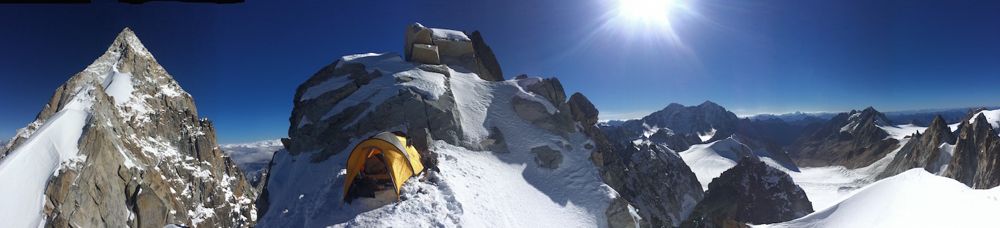
On the 30th of October we established our base camp at 13,200’. After only one day of organizing, we made our way to Camp 1 at 15,700’. In two days we were established at Camp 2 at 17,300’ after an arduous climb up the steep north side of the mountain on ice, loose rock, and rotten snow. In two more days we were set up at Camp 3 at 18,200’ on the west ridge of Hkakabo Razi. We hadn’t seen the summit since leaving base camp: Living up to its mystery, the peak kept itself hidden by rock gendarmes.
After a single rest day, Renan, Cory, and Mark headed for the top with supplies for one bivy. After eight hours of climbing, the three hunkered down for a windy, freezing, and mostly sleepless night. To give an idea of the complicated, circuitous nature of the route, they had gained only a few hundred feet in elevation from our high camp. After a few hours the next morning, a little beyond the Japanese high point, Mark arrived at a spot from which he could see the rest of the route to the summit, and he knew the climb was over. The terrain ahead would undoubtedly require a second bivy, this time without the tent and sleeping bags they had left behind.
The unfortunate consequence of climbing a serrated ridge of rock and ice meant the retreat took nearly as long as the ascent, and the three did not return to high camp until sunset. Their high point on the west ridge was 18,840’. Mark guessed there was another 500–700’ of elevation gain to reach the summit.
Our trip was far from over. We still had nearly 150 miles of downclimbing and jungle walking to reach civilization. We spent the better part of two weeks, with no rest days and not nearly enough food, retracing our steps. Despite the hardships of the trip, it was a comfort to walk over familiar terrain. The summit elevation of Hkakabo Razi is still a mystery and its reputation as, in Ozaki’s words, “one of the most difficult and dangerous mountains in the world,” has been cemented in my mind.
– Hilaree O'Neill, USA
Click here to download an article by Tamotsu Nakamura covering the geography and climbing history of Hkakabo Razi and Gamlang Razi, originally published in Japanese Alpine News (vol. 16, 2015).
Media Gallery


