

Kokodak Dome, South Ridge
China, Xinjiang, Western Kun Lun
An unclimbed 7,000m peak? Yes, but then maybe no. Yes, because until July 24 no climber had set foot on the ca 7,129m summit of Kokodak (a.k.a Kokodag) Dome. No, because the prominence of Kokodak Dome with respect to neighboring Kokodak Peak (7,210m) is not exactly known, and may not match the requirement for a high mountain range such as the Kun Lun. Defining prominence for an independent mountain is the subject of much debate. It is generally considered to be at least 100m in the Alps, rising to 500m in the Himalaya. But there are few official criteria, and certainly none for the Kun Lun.
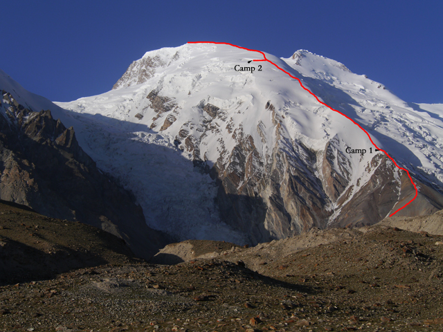
The Dome is situated in the Kongur group, to the northwest of Kokodak Peak(KokodakI), which was climbed in 2006 by an American-Russian expedition led by Lev Ioffe (AAJ 2007). Our trip was organized by the German tour operator AMICAL, led by the prominent German climber Luis Stitzinger, and began on July 6. We were 14 climbers from Austria and Germany, along with two Nepalese Sherpas.
On July 12 we established base camp at 4,300m, the same place the Russians had chosen in 2006. During the next 10 days we made several approaches to higher elevations, setting up an intermediate camp at 4,850m, then Camp 1 on an exposed snow ridge at 5,525m (a bit higher than Camp 1 of the 2006 expedition), and finally Camp 2 at 6,300m. Chhongba Sherpa and Singi Lama fixed ropes on the riskiest parts of the route. Above intermediate camp, the terrain became considerably steeper, leading through scree fields to snow-covered and glaciated areas, with a constant angle of 40–50°. Above Camp 1 we climbed an exposed snow ridge comparable with the famous Biancograt on Piz Bernina in Switzerland. Further up were slopes with knee-deep snow, where we had to circumvent some crevasses and seracs. We followed more or less the same route as the 2006 expedition to about the same altitude as our Camp 2, where they traversed right. Above, we entered untrodden territory.
The weather during the first one and a half weeks had been perfect, with sunshine, little wind, and no snowfall. We decided to start from base camp for a summit attempt on July 22. The stages were long and challenging, each with 800m height gain. However, we were now in good shape and well acclimatized.
At 3 a.m. on the 24th we set off from Camp 2. In contrast to previous days, it was cloudy and windy, but despite an early temperature of –10°C, not too cold. We divided into three groups, with the strongest breaking trail through some knee-deep snow at ca 30°. At 8 a.m. Luis reported over the radio, "We can see the summit for the first time." This proved rather premature, because farther up the last slope he realized there were three peaks at approximately the same altitude. They had to use GPS to determine which was the highest. At 9 a.m. the first group reached the highest top (38°38'04.3"N, 75°08'51.9"E, 7,137m GPS). The next group followed at 9:45, the third at about 10:30.
Clouds were passing the top at a great speed, and we could not see the Takla Makan Desert, although every now and again some high neighboring summits, such as as Kokodak Peak and Kongur Tiube (7,530m), appeared through the cloud. Stitzinger later estimated wind speeds at 60–80 kph. Some members of the first group descended to base camp the same day, others followed the day after.
The names of all summiters are: Chhongba Sherpa, Sven Deutschmann, Edith and Richard Goldeband, André Guenzel, Josef Kirchner, Manuel Moeller, Stefan Nestler, Eva-Maria Ramsebner, Volker Schuhmann, Juergen Schuetz, Singi Lama, Luis Stitzinger, Johannes Strohmaier, Ursula Teichmann, Jan Wienands.
Stefan Nestler, Germany
Media Gallery


