

Traverse of Peak 4,810m, 1,000 Years of Russian Christianity, and Kotina; new route on Kotina; various other ascents
Kyrgyzstan, Pamir Alai, Karavshin

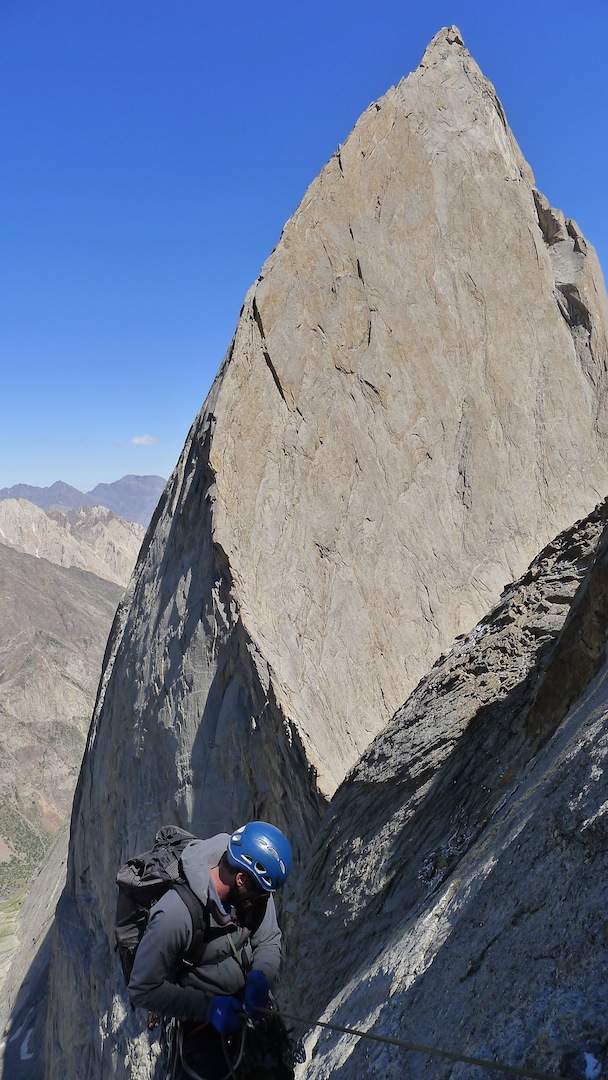
In mid-July I traveled to the Karavshin region with Peter Fasoldt. Our goal was the first alpine-style enchainment of the three major peaks dividing the Ak-su and Kara-su river valleys: Peak 4,810m, Peak 1,000 Years of Russian Christianity (4,507m), and Kotina (4,520m). Viewed from the east, these mountains form an elegant ridge of golden granite rising 6,000 feet above the valley floor. The ridge runs two miles in linear distance, all of it steep and technical.
A hot but flat 30-mile hike brought us to base camp in the Kara-su. We had planned to camp in the Ak-su, many miles closer to the peaks we wanted to climb, but the Kyrgyz Army chopper pilots we’d paid to shuttle our equipment dropped it in the wrong valley. We discovered this at the road head, and there wasn’t much we could do but hike in.
We arrived under stormy skies and stricken with dysentery after drinking water from the Karavshin River. Our friendly camp cook, Victor, offered a folk remedy: a shot of vodka mixed with a heaping teaspoon of salt. It didn’t work. Stewing in the cook tent, the resident climbers complained about the scuddy weather pattern. But a few days after we arrived on July 26, a windy storm blew through the area. For the next month we had mostly clear skies with occasional afternoon squalls.
We chose a new line on the relatively unexplored west face of Kotina for our first attempt. Other than the 2006 Polish line Czarna Wolga (AAJ 2007), we knew of no other routes to the summit on this 5,000-foot face. From base camp, we hiked southeast toward the col between Kotina and Peak 4,810, then cut back north on a ledge system that took us past a rockfall zone and up some slabs to a large orange block. From here we trended generally up and left over 5.9 terrain for about 500 meters. On a ledge below a prominent orange buttress, we stepped right into a low-angle system for about 150 meters, followed by another 150 meters of steeper rock to gain the large ledge on top of the buttress. We scrambled left up a ridge for another 200 meters, then improvised our way up a steep snowfield and on to the summit. It was 4 p.m. We had some bivy gear, but we hoped that we wouldn’t have to use it.

The Poles had reported a difficult descent to the east and into the Ak-su, which we hoped to avoid by descending to the north then back west into the Kara-su. Just below the summit I set off a talus explosion that ended with my left ankle trapped Aron Ralston–style under a huge block. Pete built a haul system to hoist it off of me, and by some miracle I escaped with only minor lacerations. Nice to have a solid partner. Clouds engulfed the mountain and night fell quickly. Like the Poles, we got sucked down the massive east face of Kotina. We rappelled many times with our single rope. Around midnight we bivied on the only ledge in sight. The next morning we landed safely in the Ak-su. We called our route An Inconvenient Truth (1,200m, VI 5.9+).
We decided to repeat some established lines next. We climbed the incredible Perestroika Crack (900m, VI 5.12a) on Russian Tower (Peak Slesova) in about 20 hours camp-to-camp. Then we climbed the Big Yellow Moon variation (700m, VI 5.12a) on the southwest arete of the Central Pyramid. Carrying Petzl 8.8mm aluminum bolts and hangers is essential, along with a keen eye to spot the in situ sleeves they screw into. Later in the trip we would also repeat the Alperien route (V 5.10+) on Asan, an excellent wide crack route offering incredible views of the west face of 4,810 on the descent.
After a few days of rest we were geared up for an attempt at the big traverse. On August 14, we hiked south up the Ak-su valley, scrambled 1,000 meters up to the col between Asan and Russian Christianity, and then bivied below the finger crack marking the start of the regular south face route on 4,810 (700m, V+ 5.10+). The south face is mostly 5.7–5.9 on good rock, with five or six sections of harder climbing up to 5.10+. We were able to short-fix almost all of it, and by 2 p.m. we were on the summit, just in time for the daily storm, which arrived like clockwork.
The storm intensified into one of the strongest we saw on our trip as we descended the north face of 4,810. The face ran with water, and snow sloughed down around us. About 500m lower we found a protected bivy site just east of the small rock spire between 4,810 and Russian Christianity. We spent a cold, wet night dreaming of morning sun. When it finally arrived, we climbed 100 feet of verglassed 5.9 up the west face of the rock spire to gain some elevation, then embarked on a series of traversing rappels that landed us in a gully somewhere above the col between 4,810 and Russian Christianity. A rising traverse followed by two more rappels and some downclimbing brought us to the col proper.
We started climbing the south ridge of Russian Christianity (600m, V 5.10+) around 2 p.m. and topped out around 8 p.m., after short-fixing and simul-climbing most of the route, a splitter line that we thoroughly enjoyed in the warm afternoon sun. On top of Russian Christianity we found an established bivy site just southeast of the summit block, where we spent a plush night.
The next morning we traversed the amazing ridge between Russian Christianity and Kotina. We climbed unroped for about a quarter mile, then tied in when things got more technical and exposed. A couple of hundred meters later we started rappelling, traversing north once more toward Kotina. We landed on more ridge terrain and traversed along an intrusive band for another quarter mile to the base of the south face of Kotina, which may not have been climbed previously. Climbing through a steep crack down low, we aimed for a prominent corner system on the south ridge, which offered an athletic pitch of 5.11. After about 1,000 feet, we reached lower angle terrain and unroped. In another 500 feet of scrambling, we passed some tat left by the Poles in 2006 and started to recognize features we had seen on our first trip up Kotina.
Around 3 p.m. on August 17 we reached the summit, where Pete came up with the bright idea to descend An Inconvenient Truth rather than try to contour north and west, an endeavor at which we had failed the last time we attempted it. We sped down familiar terrain, stretching the ropes and downclimbing where possible to save what little bail gear we had left after 50 rappels. We even managed to retrieve a No. 2 Camalot I had forgotten at a belay while climbing An Inconvenient Truth. By 8 p.m. we were back on the ground. There was about one foot of cord and one brass nut left on the rack.
Running the ridge between the Ak-su (“white water”) and Kara-su (“black water”) river valleys, the Clear Water Traverse (VI 5.11) was an unforgettable adventure with my good friend Pete.
Joshua Finkelstein, AAC
Editor’s note: During the summer of 2012, German climbers Joe Habel and Laurin Wissmeier climbed a long variation to An Inconvenient Truth (Fasoldt-Finkelstein, 2012) on Kotina, which they called Awesome Fucking Dihedral. The two climbed 10 or 11 new pitches up a prominent corner system, all free at French 6c, leaving only one piton. They report that the route has “outstanding quality at a moderate grade and length,” and that the fourth pitch, in particular, deserves five stars.
Media Gallery


