

Asia, India, Zanskar, Reru Valley, Various Ascents

Two flights, three days of bum-bruising off-road driving, and two days of scenic hiking brought us to our base camp (4,600m, 33°16'19.52"N, 76°54'20.20"E) in an arena of unclimbed mountains. It was September 1, and we were in a western branch of the Reru Valley (sometimes as Raru), known locally as the Tetleh (Tetli) Valley, and rising from Onkar. Our goal was supposedly unclimbed R6 (6,177m on the Sakamoto map and the highest in the valley; see AAJ 2010). The team comprised Johnny Bull, Robin Jones, Kunal Masania, Johnny Moodie, Joe Prinold, Dominic Southgate, liaison officer Anupam Mukherjee, and me. With so many of us, we split into two teams of four and approached R6 from opposite flanks. One team would go up a steep gully on the east side, while the other would climb the icy and rocky slopes of the southwest side.
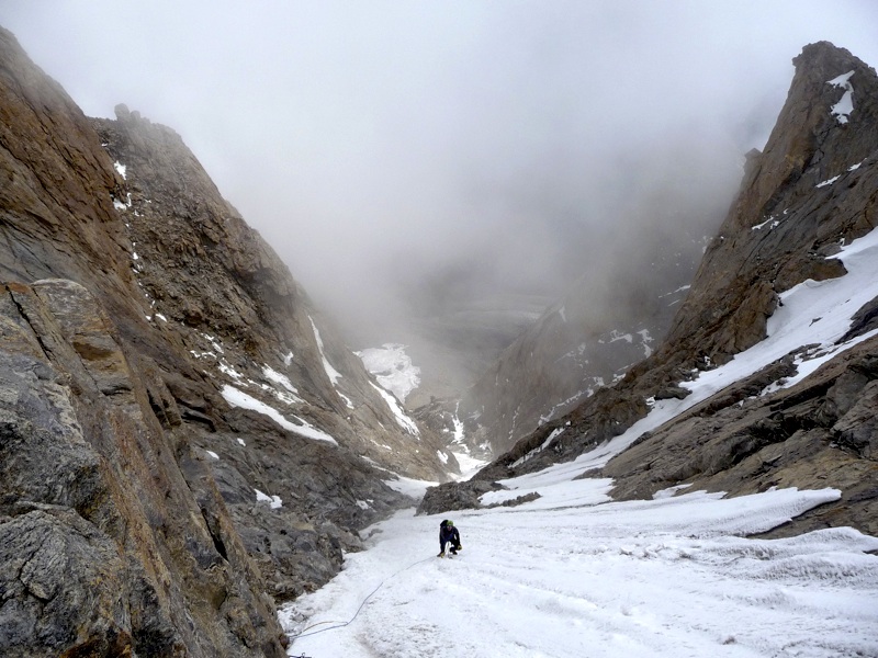
Johnny B., Kunal, Robin, and I set up an advanced base camp at 5,300m. near the bottom of the gully. and next morning trudged up hundreds of meters of steep snow, moving together with thumping heads. After 400m of Scottish Grade I, the gully steepened and became icier. For the next 500m the gradient never exceeded 70°, but our energy got lower. At the cornice we played rock, paper, scissors for the finishing lead. Johnny “won,” and charged up with surprising enthusiasm, reaching the summit, on which our GPS recorded 6,276m—100m higher than we expected. The other team had already summited and left 30 minutes earlier. We admired the view but noticed an old cairn and piece of faded tat that appeared to have been on this not-quite-virgin summit for at least a few years. We quickly set off down the southern slope. We suspect that the mountain had been climbed from the neighboring Temasa Nala to the north. The Tetleh Valley is known locally for the story of a lama who hundreds of years ago meditated in a cave (Lama Jimsa, Place where the Lama Sat). We named R6 Lama Jimsa Kangri.
Kunal and Johnny B. attempted a rocky ridge leading toward a summit of ca 5,700m (33°13'52.97? N, 76°53'23.05? E) below R13. They started from a camp at 5,100m on the glacier, but when 150m below the summit, came to a steep icefield, which they were unable to cross, having left crampons where they joined what had appeared to be a continuous rock ridge.
Meanwhile Johnny M., Dominic, and Robin set out to climb R2, on the west side of the valley. Their route took a loose gully for 800m. At 5,600m they climbed out of it, rappelled off the east ridge to an adjacent glacier, and camped at 5,500m. The following day they crossed the glacier to the south ridge of R2 and found a low-angle boulder field that circled the mountain to the summit. The GPS read 5,930m, and the peak was named Moel Kangri.
Joe and I climbed the 700m wall above base camp and a little north of R14. The nice-looking rock gave ca 20 pitches of British HS to HVS, with sections of very good climbing.
Joe and I had our minds set on an east-facing rock spur on the west side of the valley, leading to R4 (6,080m on Sakamoto map). We camped near the base of the spur at 5,000m and started climbing at 3:30am. After 200m of scrambling we arrived at the main spur just after sunrise, roped up, and moved together, occasionally belaying short sections. The climbing varied from HS to HVS. Above 800m of superb slabs, the spur steepened. At 6,000m, and at least four or five pitches below the summit, we noticed dark clouds coming down the valley. A few wisps of snow began to fall, convincing us to descend. After a cold, snowy night on a ledge at 5,700m, we continued down the following day.
On what proved to be the final foray, Kunal and Johnny B. set off for a long rock route higher up the glacier but adjusted their objective with bad weather coming from the Miyar. They chose a steep mixed line on a peak west of R13, which led onto 80° snow slopes near the top. They reached the summit (5,985m on a calibrated Suunto) at 3:45pm and didn’t get down until well past dark. The difficulty rated Scottish III/IV mixed, and the 700m route had an overall alpine grade of about TD. They called it Bhaio aur bheno ki khushi. We left base camp on September 19, heavy snowfall, heralding the start of winter and making routes up the glacier out of the question. The expedition thanks Imperial College Exploration Board, Old Centralians Trust, Imperial College Trust, Mount Everest Foundation, Welsh Sports Association, The Lyon Award, and the Mountaineering Council of Scotland for financial support.
Virgil Scott, U.K.
Media Gallery


