Samurai Direct
The First Ascent of the Southeast Face of Kamet in India
 Our plan to climb Kamet was not the result of any snap decision. We had faced many challenges before, and although confidence was born from these experiences, so too was fear and anxiety. At 7,756 meters, Kamet is the highest climbable mountain in the Garhwal region of India (since Nanda Devi is still off-limits). We’d collected many reports from other climbers and had studied photographs of the mountain, but we knew this research could not reveal Kamet’s true nature. Many climbers had been overwhelmed by the mountain, and it still had unexplored faces. Why? We could not know the answer until we had gone to have a look for ourselves, and no amount of knowledge would ease our anxiety until we had traversed the final ridge to the summit.
Our partnership in the highest mountains began when we climbed a new route on the northwest side of Spantik (7,028 meters) in Pakistan in 2004. [Editor’s note: This line previously had been descended twice following climbs of other routes on Spantik.] After that climb, we decided to extend our trip and climb the north face of Laila Peak (6,096m), near the Gondogoro Glacier. Our desire for new challenges was honed by these experiences. The sharp peaks of ice and snow drew our eyes.
The next year we climbed new lines on the east ridge of Muztagh Ata (7,546 meters) in China and the north face of Shivling (6,543 meters) in India, and on the latter both of us got severe frostbite. Kazuya lost four of his toes. Although we didn’t climb together for three years after the struggles on Shivling, each of us kept exploring. Kazuya climbed Broad Peak and Gasherbrum II. Kei climbed Manaslu and Everest. Those experiences made us smarter and more serious about our lives. A beautiful climb, we believe, must include coming back alive.
Exploration of Kamet’s giant pyramid dates back to 1855, and it was first climbed in 1931 by a British expedition led by Frank Smythe, via the Purbi (East) Kamet Glacier, Meade’s Col, and the northeast ridge. It was then the highest mountain ever summited. Most ascents since have followed the same route, giving many climbers a good look at the 1,800-meter southeast face, which rises from the head of the Purbi Kamet Glacier. In 2005 the mountain was reopened to foreigners after having been off-limits for decades. Americans John Varco and Sue Nott hoped to try the southeast face in 2005, but poor weather kept them from even setting foot on the route—they hardly even saw it.
We wanted to maximize our chances to reach the summit. We did not want anyone to say, “What is your big excuse? You could not climb because of the bad weather?” We didn’t have enough money to contract a company that provides weather forecasting in the Himalaya, so after establishing our base camp (4,700 meters) at the confluence of the Raikana and the Purbi Kamet glaciers on September 1, we called friends in Japan every few days by satellite phone to check the forecast for Joshimath, the closest town. But we soon learned that the forecast for Joshimath had little to do with what was happening on Kamet. When the forecast said Joshimath would have rain, Kamet would have blue sky.
Instead, we watched the clouds over Kamet, and soon we discovered a common denominator for good weather: the wind direction. When the winds blew from the southwest, Kamet had mild weather; a strong south wind would clear the sky over the peak. When the wind reversed, the weather always deteriorated and heavy rain or snow began. These were big lessons for us.
We acclimatized in two stages. From September 4 to 7, we made a round-trip to the foot of the face at 5,750 meters, with two camps on the Purbi Kamet Glacier, and we found that the avalanche danger did not appear too serious in the main couloir on the wall. After two rest days in base camp, we climbed the normal route to 7,200 meters, above Meade’s Col, to acclimatize and explore the descent route. We camped at 6,600 meters for two nights to study the face, focusing on three main concerns: the three obvious cruxes on the route, the possibility of avalanche danger from the serac at the top, and the places where we would bivy. We left a cache of food and fuel at 6,600 meters for our descent and returned to base camp on the 16th.
For the next week, as heavy snow fell, we discussed the food and equipment that we would carry on the wall. We decided to bring a foam mat cut in two and a 600-gram, three- quarter-length sleeping bag that we would share. A small Gore-Tex tent. Two 50-meter, 7.5mm ropes. And a small rack, mostly ice screws.
We knew that lighter weight would be one key to success, but we also wanted to make sure we had enough food. We had not forgotten the lesson from Shivling, and now, with more experience under our belts, we focused on the balance of nutrition and calorie intake per day. Our motto was “sleep well and eat well, and the next day we can climb without fatigue.” We packed food for five days plus some emergency food. In the end, it took us six days to climb the wall instead of our planned four days. But because of the extra food, we were not nervous about the delay.
During our preparation, we argued endlessly about what to bring—it was a long process. However, that process made us more confident in our gear, and the result was nearly perfect.
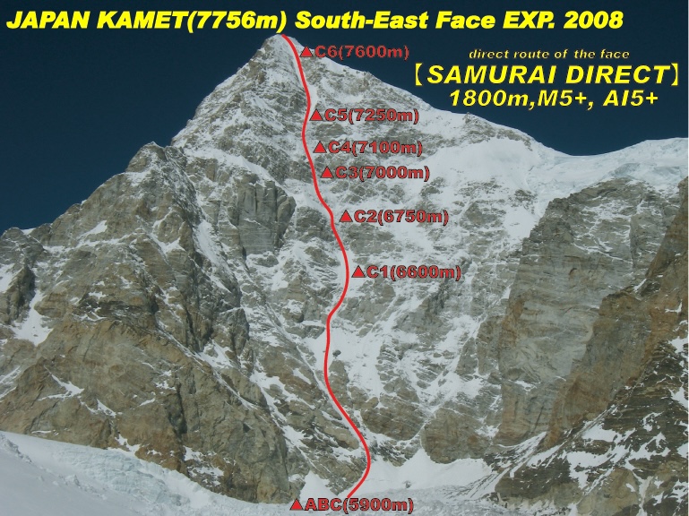
The bad weather at base camp lasted more than a week. When we had almost given up hope, the wind changed and good weather came back. We started toward the wall on September 26 in soft, deep snow. There was one meter of new snow at Camp 1 and 1.5 meters of snow at Camp 2. It took twice as long to reach the wall as it had before. We had to dig out our half-destroyed tent at Camp 2, but it was still usable. We established advanced base camp at 5,900 meters, at the foot of the face, on September 28. The line was obvious, following a sinuous couloir directly to the top: perfect and beautiful. We no longer had any doubts.
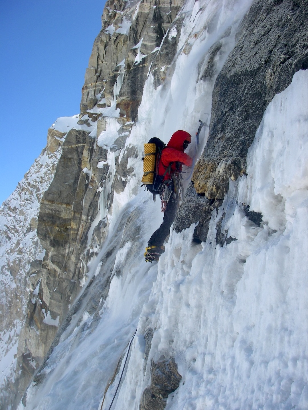
In the morning the sky was bright and clear. The climbing was not very difficult, and we only belayed toward the end of the day. At 6,600 meters, below the obvious first crux section, we spent an hour and a half chopping into the ice to make a small shelf. On this wall, we would never find a comfortable place for two people to sleep, but we are small and we only had a single half sleeping bag, so small ledges were enough. First we lay down both facing to the right, and after two hours we turned over and faced the opposite direction. That night was freezing, under millions of stars.
The first steep crux had rotten ice and loose rock covered by dry snow. In the afternoon, spindrift avalanches poured down the face, blinding us and making for freezing belays. The effort of climbing did not stop our bodies from shaking with cold. At 6,750 meters, we found a small snow ridge where we chopped out a tent site that was a little better than the last one. During the night, our tent was pelted with small avalanches and stones.
Our reconnaissance had us worried about the next crux, but the truth was way beyond our expectations. Loose rock and rotten ice were everywhere. After chopping away 30 centimeters of bad ice, we’d find black ice underneath. It was difficult to find the way, and at nearly 7,000 meters it was hard to breathe. Negative thoughts passed through our minds: Why do we climb? What is the meaning of so much sacrifice? At the end of the day, we were only halfway up the steep wall. We made a tension traverse to a small snowfield under an overhang and set up a bivy at 7,000 meters, cutting ice as usual. By the time we crawled into the refuge of our little tent it was past midnight.
The next day was short. Two more pitches saw us to the end of the second crux passage, and then two and a half pitches of steep snow brought us to the base of the third crux. It looked bigger than we had expected. Exhausted from the previous night’s brief sleep, we didn’t have the time or energy to start up this wall, so we cut a ledge and set up the tent at 3 p.m. We knew we were moving slowly on the face, but we were confident in the weather. We could not stop shivering, though, and at night we massaged each other’s feet. Kazuya was very worried about his toes and asked for an injection of Lovenox to improve his blood flow.
“Where should I inject it?”
“Anywhere!”
He didn’t want to lose more toes.
On the fifth morning of the climb, we traversed to the base of the third steep wall. The first pitch was mixed, followed by three and a half pitches of hard alpine ice. Finally we entered the Banana Couloir, the snow gully leading to the top, at about 7,250 meters. The scenery from this elevation was stupendous—words cannot express it—but even though the world was beautiful our bodies felt ugly. We could barely speak, but we encouraged ourselves by saying, “The summit is tomorrow!”
That snow couloir seemed endless, however, and we moved so slowly. We could see the summit ridge, but it never seemed to get any closer.
“I’m dying, I’m dying,” Kei muttered, and Kazuya responded, “Don’t worry, you’re not dying.”
Then he asked, “Do you want to go down?”
“No, no,” she said. “Let’s go up.”
We bivied in a crevasse just 150 meters below the summit. We could see the top, but we did not have the energy to continue. There wasn’t much food left, but we didn’t have any appetite anyway.
On the morning of October 5, the seventh day of the climb—10 days out from base camp—the eastern horizon was flooded with gorgeous orange light as the sun rose from behind the right flank of Mt. Kailash. We traversed over the ridge above our bivy onto the upper northeast face, and by 10 a.m., after an hour of snow climbing, we were on top. The weather was clear, and we enjoyed a majestic 360-degree view, with the curve of the Earth visible at the horizon— a view entirely different from what we’d been able to see during the climb. We reveled in our new perspective.
Summary:
Area: Central Garhwal, India
Ascent: Alpine-style first ascent of the southeast face of Kamet (7,756m), by the route Samurai Direct (1,800m, WI5+ M5+), Kazuya Hiraide and Kei Taniguchi. Leaving base camp on September 26, the two Japanese walked three days up the Purbi Kamet Glacier to advanced base camp at 5,900m, and then climbed the face with six bivouacs, summiting October 5, 2008. They descended the northeast face (the 1931 first-ascent route) to a food and fuel cache they had left at 6,600m, and the next day they continued down to Camp 2 on the glacier. They reached base camp before dawn on October 8, nearly 13 days after leaving, after walking through the night.
A Note About the Authors:
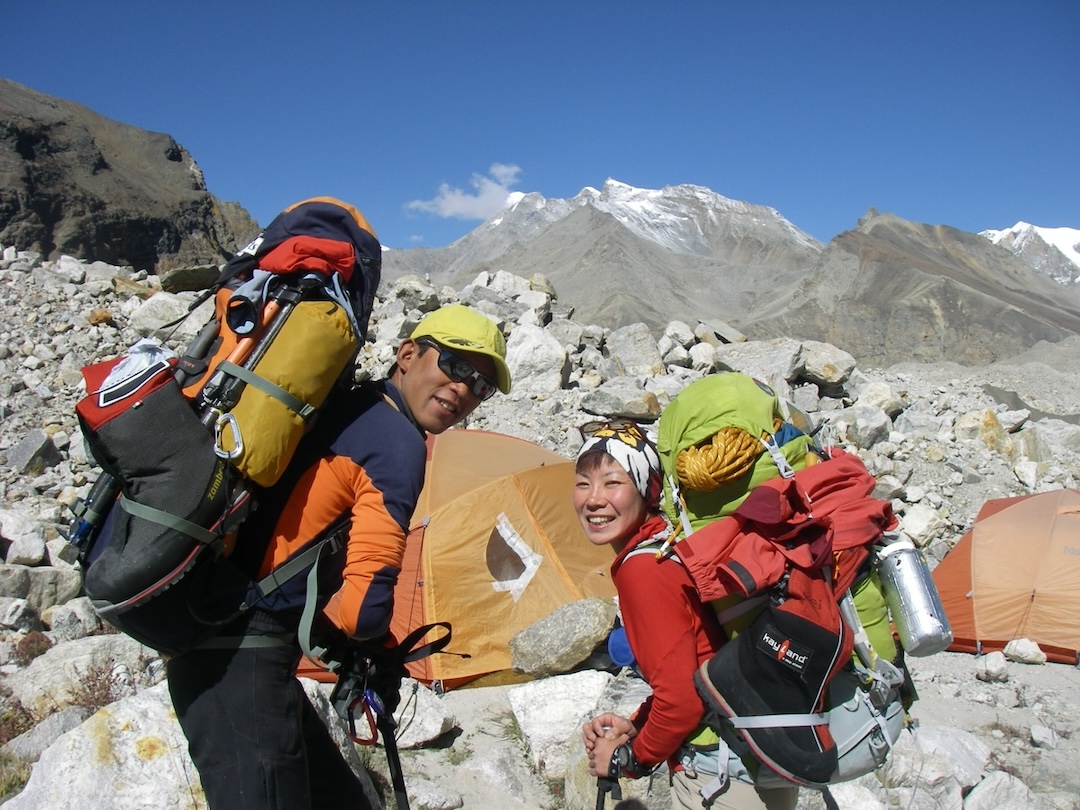
Kazuya Hiraide, 29, works in the ICI Sports shop in Tokyo. Kei Taniguchi, 36, also lives in Tokyo, where she works as a facilitator for corporate team-building.
Media Gallery